Hannoveri Stadtbahn
| Hannoveri Stadtbahn | |
 | |
 | |
| Adatok | |
| Ország | |
| Helyszín | |
| Típus | Stadtbahn |
| Átadás | 1975 |
| Vonalak száma | 12 + 2 |
| Általában használt jármű |
|
| Nyomtávolság | 1435 mm |
| Áramellátás | felsővezeték |
| Feszültség | 600 V DC |
| Üzemeltető | |
| Üzemeltető | üstra |
| Tulajdonos | Infra Infrastrukturgesellschaft Region Hannover GmbH (infrastruktúra) |
| Elhelyezkedése | |
A Wikimédia Commons tartalmaz Hannoveri Stadtbahn témájú médiaállományokat. | |
| Sablon • Wikidata • Segítség | |
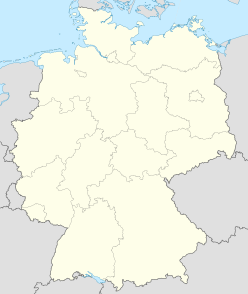
Hannoveri Stadtbahn (német nyelven: Stadtbahn Hannover) Németország Hannover városában található Stadtbahn hálózat. Összesen 12 + 2 vonalból áll, a hálózat teljes hossza 123 km, Az állomások és megállók száma 197. Jelenlegi üzemeltetője a üstra.
A vágányok 1435 mm-es nyomtávolságúak, az áramellátás felsővezetékről történik, a feszültség 600 V egyenáram. A forgalom 1975-ben indult el.
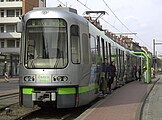
Érdekesség, hogy a város feleslegessé vált TW 6000 sorozatú stadtbahn kocsijai használtan Budapestre kerültek. Ezek a kocsik a Hannoveri, Teve és Banán beceneveket kapták.
Útvonalak
[szerkesztés]| Vonal | Járat | Útvonal | Hossz | Megállók | Menetidő csúcsidő (átlag) |
Átlagsebesség | Átlagos megállótávolság |
|---|---|---|---|---|---|---|---|
| B | 1 | Langenhagen – Alter Flughafen – Büttnerstraße – Dragonerstraße – Hauptbahnhof – Kröpcke – Aegidientorplatz – Peiner Straße – Bothmerstraße – Laatzen/Birkenstraße |
27,7 km | 44 | 64,5 min | 25,8 km/h | 645 m |
| B | 2 | Alte Heide – Vahrenheider Markt – Büttnerstraße – Dragonerstraße – Hauptbahnhof – Kröpcke – Aegidientorplatz – Peiner Straße – Bothmerstraße – Laatzen/Birkenstraße ab 21 Uhr bis Peiner Straße vereint mit Linie 8 (Y-Verkehr) |
19,1 km | 34 | 45 perc | 25,5 km/h | 580 m |
| A | 3 | Altwarmbüchen – Paracelsusweg – Noltemeyerbrücke – Vier Grenzen – Lister Platz – Hauptbahnhof – Kröpcke – Waterloo – Stadionbrücke – Bahnhof Linden/Fischerhof |
18,4 km | 31 | 41 perc | 26,9 km/h | 615 m |
| C | 4 | Garbsen – Bahnhof Leinhausen |
19,7 km | 33 | 44 perc | 26,9 km/h | 615 m |
| C | 5 | Stöcken – Bahnhof Leinhausen |
17,1 km | 29 | 40 perc | 25,7 km/h | 610 m |
| C (és D-Süd) |
6 | Nordhafen – Bahnhof Nordstadt |
17,9 km | 30 | 39 min | 27,5 km/h | 615 m |
| A | 7 | Misburg – Paracelsusweg – Noltemeyerbrücke – Vier Grenzen – Lister Platz – Hauptbahnhof – Kröpcke – Waterloo – Stadionbrücke – Bahnhof Linden/Fischerhof im Nachtsternverkehr über Schwarzer Bär |
17,5 km | 30 | 39,5 min | 26,6 km/h | 605 m |
| B | 8 | (Dragonerstraße –) Hauptbahnhof – Kröpcke – Aegidientorplatz – Peiner Straße – Bothmerstraße – Am Mittelfelde – Messe/Nord ab 21 Uhr bis Peiner Straße vereint mit Linie 2 (Y-Verkehr), im Nachtsternverkehr Alte Heide – Messe/Nord |
8,6 km | 13 | 17,5 perc | 29,5 km/h | 715 m |
| A | 9 | Fasanenkrug – Bothfeld – Noltemeyerbrücke – Vier Grenzen – Lister Platz – Hauptbahnhof – Kröpcke – Waterloo – Schwarzer Bär – Lindener Marktplatz – Am Soltekampe – Empelde | 16,2 km | 29 | 42 perc | 23,1 km/h | 580 m |
| A (és D-West) |
Ahlem – Brunnenstraße – Leinaustraße – Am Küchengarten – Glocksee – Humboldtstraße – Waterloo – Kröpcke – Hauptbahnhof Nachtsternverkehr |
7,5 km | 14 | 20 min | 22,5 km/h | 575 m | |
| D | 10 | Ahlem – Brunnenstraße – Leinaustraße – Am Küchengarten – Glocksee – Goetheplatz – Steintor – Hauptbahnhof/ZOB | 6,1 km | 13 | 19,5 perc | 18,8 km/h | 510 m |
| C | 11 | Haltenhoffstraße – Christuskirche – Steintor – Kröpcke – Aegidientorplatz – Marienstraße – Hannover Congress Centrum – Zoo | 7,3 km | 12 | 16,5 perc | 26,5 km/h | 665 m |
| C (és D-Süd) |
16 | Königsworther Platz – Steintor – Kröpcke – Aegidientorplatz – Marienstraße – Kinderkrankenhaus auf der Bult – Brabeckstraße – Kronsberg – Messe/Ost (EXPO-Plaza) alkalmi járat a Messe-re és más eseményekre |
12,4 km | 20 | 25 min | 29,8 km/h | 655 m |
| D (és A-Süd) |
17 | Hauptbahnhof/ZOB – Steintor – Goetheplatz – Schwarzer Bär – Stadionbrücke – Bahnhof Linden/Fischerhof |
5,6 km | 12 | 17 perc | 19,8 km/h | 510 m |
| B | 18 | Hauptbahnhof – Kröpcke – Aegidientorplatz – Peiner Straße – Bothmerstraße – Am Mittelfelde – Messe/Nord alkalmi járat a Messe-re |
8,6 km | 13 | 17,5 perc | 29,5 km/h | 715 m |
Képgaléria
[szerkesztés]Irodalom
[szerkesztés]- Achim Uhlenhut: Nahverkehr in Hannover. GeraNova Zeitschriftenverlag, München 2000, ISBN 3-89724-703-8.
- Dieter Eisfeld: Stadt und öffentlicher Nahverkehr: Der Fall Hannover 1852–2000. ÜSTRA, Hannover, 2001, ISBN 3-9802783-0-1 (auf S. 51 Netzentwicklung grafisch).
- Peter Sohns: Linienchronik der Straßen- und Stadtbahn Hannover 1872–2003. Arbeitsgemeinschaft Blickpunkt Straßenbahn, Berlin 2003, ISBN 3-926524-22-7.
- Horst Moch: Straßenbahn in Hannover. Verlag Kenning, Nordhorn 2004, ISBN 3-933613-45-0.
- Robert Schwandl: Hannover Stadtbahn Album. Robert-Schwandl-Verlag, Berlin 2005, ISBN 3-936573-10-7.
- Dieter Apel u. a.: Mittendrin statt drunterdurch, Oberirdische Stadtbahnstrecke D – Impuls für die City 2020. BIU und VCD, Hannover 2009, ISBN 978-3-922883-26-5.
- Frank Stiefenhofer: Die D-Linie – Entwicklungskonzepte für eine Stadtbahnstrecke in Hannover und deren Wirkungen auf die Innenstadt. Diplomica Verlag, Hamburg 2009, ISBN 978-3-8366-3299-7.
- Michael Narten, Achim Uhlenhut: 125 Jahre Üstra: Unterwegs in Hannover. Leuenhagen & Paris, Hannover 2017, ISBN 978-3-945497-04-3.
További információk
[szerkesztés]- ÜSTRA-Homepage
- Stadtbahn mit System[halott link], ÜSTRA-Broschüre 2000 (PDF-Datei; 908 kB)
- Einsteigen: Die Stadtbahn, ÜSTRA-Broschüre August 2008 (PDF-Datei; 991 kB)
- Infra, Informationen, Pläne und Fotos zu aktuellen Stadtbahn-Baumaßnahmen
- Nahverkehrsplan
- Stadtbahn Hannover, private Website
- Gleisplan der Stadtbahn Hannover, private Website
Források
[szerkesztés]| S-Bahn |
| |
|---|---|---|
| U-Bahn | ||
| Stadtbahn | ||
| Villamosok |
| |
| Trolibuszok |
| |
| Egyéb |
| |
| ||
Text is available under the CC BY-SA 4.0 license; additional terms may apply.
Images, videos and audio are available under their respective licenses.


