For faster navigation, this Iframe is preloading the Wikiwand page for Fájl:Regions of Europe based on CIA world factbook.png.

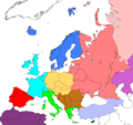
Fájl:Regions of Europe based on CIA world factbook.png

Eredeti fájl(984 × 924 képpont, fájlméret: 71 KB, MIME-típus: image/png)

Ez a fájl a Wikimedia Commonsból származik. Az alább látható leírás az ottani dokumentációjának másolata. A Commons projekt szabad licencű kép- és multimédiatár. Segíts te is az építésében!
Ez a kép elérhető vektorgrafikus (SVG) változatban is. Ha jobb minőségű, azt használd e helyett a raszterkép helyett.

File:Regions of Europe based on CIA world factbook.png → File:Europe subregion map world factbook.svg

A vektorgrafikáról a Help:SVG oldalon találsz információkat.

Más nyelveken
Alemannisch  Bahasa Indonesia  Bahasa Melayu  British English  català  čeština  dansk  Deutsch  eesti  English  español  Esperanto  euskara  français  Frysk  galego  hrvatski  Ido  italiano  lietuvių  magyar  Nederlands  norsk bokmål  norsk nynorsk  occitan  Plattdüütsch  polski  português  português do Brasil  română  Scots  sicilianu  slovenčina  slovenščina  suomi  svenska  Tiếng Việt  Türkçe  vèneto  Ελληνικά  беларуская (тарашкевіца)  български  македонски  нохчийн  русский  српски / srpski  татарча/tatarça  українська  ქართული  հայերեն  বাংলা  தமிழ்  മലയാളം  ไทย  한국어  日本語  简体中文  繁體中文  עברית  العربية  فارسی  +/−
Az új SVG kép

 
Northern Europe
 
Western Europe
 
Central Europe
 
Southern Europe
 
Southeastern Europe
 
Southwestern Europe
 
Northwest Africa
 
Eastern Europe
 
Southwestern Asia
 
Northern Asia
 
Central Asia
 
Middle East
Leírás Regions of Europe based on information form the CIA world factbook.
Dátum
Forrás en wiki
Szerző Geographyfanatic
Engedély
(Fájl újrafelhasználása)
Ezt a képet a szerzője, Geographyfanatic közkinccsé nyilvánította a(z) En-Wikipedia projektben. Ez a világ minden részén érvényes.

Egyes országokban ez jogilag nem lehetséges. Ha így van, akkor:
Geographyfanatic jogot ad bárkinek, hogy bármilyen célból, feltétel nélkül használhassa ezt a fájlt, kivéve a törvény által kötelezően előírt feltételeket.

Eredeti feltöltési napló

Az eredeti leírólap itt volt. Az itt következő felhasználónevek az en.wikipedia projektre hivatkoznak.
  • 2008-06-13 22:36 Geographyfanatic 984×924× (66327 bytes) ((Information |Description=Regions of Europe. |Source=I created this work entirely by myself based on information form the CIA world factbook. |Date=2008 |Author=~~~ |other_versions= ))
  • 2008-06-13 19:08 Geographyfanatic 984×924× (66418 bytes) ((Information |Description=Regions of Europe |Source=I created this work entirely by myself using CIA world factbook information |Date=2008 |Author=~~~ |other_versions= ))

Képaláírások

Adj meg egy egysoros magyarázatot arról, hogy mit mutat be ez a fájl

A fájl által ábrázolt elemek

mű tárgya

72 755 byte

924 képpont

984 képpont

7842360126dfd3c1071aabdc7a1a6a5aa2160a67

Fájltörténet

Kattints egy időpontra, hogy a fájl akkori állapotát láthasd.

Dátum/időBélyegképFelbontásFeltöltőMegjegyzés
aktuális2018. július 1., 19:44Bélyegkép a 2018. július 1., 19:44-kori változatról984 × 924 (71 KB)AsmodimAdded Northwest Africa region
2016. április 5., 05:15Bélyegkép a 2016. április 5., 05:15-kori változatról984 × 924 (65 KB)OgreBot(BOT): Reverting to most recent version before archival
2016. április 5., 05:15Bélyegkép a 2016. április 5., 05:15-kori változatról984 × 924 (65 KB)OgreBot(BOT): Uploading old version of file from en.wikipedia; originally uploaded on 2008-06-13 19:08:30 by Geographyfanatic
2016. március 30., 15:56Bélyegkép a 2016. március 30., 15:56-kori változatról984 × 924 (65 KB)Cc vcvc bv cbvbggbReverted to version as of 17:24, 15 September 2008 (UTC) Fixed bluriness
2008. szeptember 17., 21:35Bélyegkép a 2008. szeptember 17., 21:35-kori változatról1 377 × 1 293 (331 KB)CradelReverted to version as of 12:11, 14 September 2008
2008. szeptember 17., 12:11Bélyegkép a 2008. szeptember 17., 12:11-kori változatról638 × 599 (148 KB)F7~commonswikiCyprus (white) most of Kazakhstan (light purple) - both not in Europe per CIA
2008. szeptember 15., 19:24Bélyegkép a 2008. szeptember 15., 19:24-kori változatról984 × 924 (65 KB)TocinoReverted to version as of 18:02, 15 June 2008
2008. szeptember 14., 14:11Bélyegkép a 2008. szeptember 14., 14:11-kori változatról1 377 × 1 293 (331 KB)Cradel+Kos
2008. június 15., 20:02Bélyegkép a 2008. június 15., 20:02-kori változatról984 × 924 (65 KB)Masur((legend|#007FFF|Northern Europe))((legend|#00FFFF|Western Europe)) ((legend|#F0DC82|Central Europe))((legend|#66FF00|Southern Europe)) ((legend|#D2691E|Southeastern Europe))((legend|#FF0000|Southwestern Europe)) ((legend|#F88379|Eastern Europe))((legend|

Fájlhasználat

Az alábbi lapok használják ezt a fájlt:

Globális fájlhasználat

A következő wikik használják ezt a fájlt:

Metaadatok

{{bottomLinkPreText}} {{bottomLinkText}}
Fájl:Regions of Europe based on CIA world factbook.png
Listen to this article

This browser is not supported by Wikiwand :(
Wikiwand requires a browser with modern capabilities in order to provide you with the best reading experience.
Please download and use one of the following browsers:

This article was just edited, click to reload
This article has been deleted on Wikipedia (Why?)

Back to homepage

Please click Add in the dialog above
Please click Allow in the top-left corner,
then click Install Now in the dialog
Please click Open in the download dialog,
then click Install
Please click the "Downloads" icon in the Safari toolbar, open the first download in the list,
then click Install
{{::$root.activation.text}}

Install Wikiwand

Install on Chrome Install on Firefox
Don't forget to rate us

Tell your friends about Wikiwand!

Gmail Facebook Twitter Link

Enjoying Wikiwand?

Tell your friends and spread the love:
Share on Gmail Share on Facebook Share on Twitter Share on Buffer

Our magic isn't perfect

You can help our automatic cover photo selection by reporting an unsuitable photo.

This photo is visually disturbing This photo is not a good choice

Thank you for helping!


Your input will affect cover photo selection, along with input from other users.

X

Get ready for Wikiwand 2.0 🎉! the new version arrives on September 1st! Don't want to wait?