For faster navigation, this Iframe is preloading the Wikiwand page for קובץ:Hellinikon Airport aerial view 1998-3-9.png.

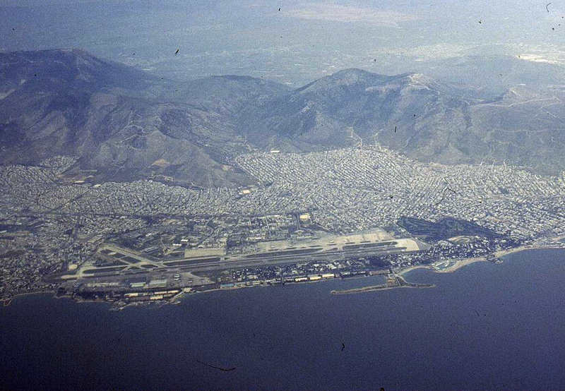
קובץ:Hellinikon Airport aerial view 1998-3-9.png
לקובץ המקורי(1,023 × 709 פיקסלים, גודל הקובץ: 2.08 מ"ב, סוג MIME‏: image/png)

ויקישיתוף זהו קובץ שמקורו במיזם ויקישיתוף. תיאורו בדף תיאור הקובץ המקורי (בעברית) מוצג למטה.
תיאור
English: Aerial view of Hellinikon International Airport (ATH / LGAT). The airport was closed in 2001.
Español: Vista aérea del Aeropuerto Internacional de Hellinikon (ATH / LGAT), cerrado en 2001.
תאריך יצירה
מקור http://www.airliners.net/photo//0061582/L/
יוצר Konstantin von Wedelstaedt
מיקום המצלמה37° 53′ 54″ N, 23° 43′ 46″ E Kartographer map based on OpenStreetMap.תמונה זו ותמונות נוספות במיקום: OpenStreetMapinfo
This file comes from the Konstantin von Wedelstaedt collection and is copyrighted.
Note: This permission only extends to photos taken by Konstantin von Wedelstaedt. It does not include any other content from airliners.net
GNU head מוענקת בכך הרשות להעתיק, להפיץ או לשנות את המסמך הזה, לפי תנאי הרישיון לשימוש חופשי במסמכים של גנו, גרסה 1.2 בלבד כפי שפורסמה על־ידי המוסד לתוכנה חופשית; ללא פרקים קבועים, ללא טקסט עטיפה קדמית וללא טקסט עטיפה אחורית. עותק של הרישיון כלול בפרק שכותרתו הרישיון לשימוש חופשי במסמכים של גנו. 1.2 בלבד
VRT Wikimedia

אישור השימוש בקובץ זה / קבצים אלה עבר וידוא, המאוחסן במערכת VRT. הוא זמין תחת כרטיס מספר #2009101910049548 עבור משתמשים בעלי גישה למערכת זו.
כדי לוודא את האישור, אנא פנו למשתמשים בעלי גישה ל-VRT.

הקישור לכרטיס : https://ticket.wikimedia.org/otrs/index.pl?Action=AgentTicketZoom&TicketNumber=2009101910049548
Find other files from the same ticket: SDC query (SPARQL)

כיתובים

נא להוסיף משפט שמסביר מה הקובץ מייצג

פריטים שמוצגים בקובץ הזה

מוצג

37°53'53.999"N, 23°43'45.998"E

היסטוריית הקובץ

ניתן ללחוץ על תאריך/שעה כדי לראות את הקובץ כפי שנראה באותו זמן.

תאריך/שעהתמונה ממוזערתממדיםמשתמשהערה
נוכחית00:26, 21 בינואר 2012תמונה ממוזערת לגרסה מ־00:26, 21 בינואר 2012‪709 × 1,023‬ (2.08 מ"ב)Jetstreamer((Information |Description =((en|1=Aerial view of Hellinikon International Airport (ATH / LGAT). The airport was closed in 2001.)) |Source =http://www.airliners.net/photo//0061582/L/ |Author =Konstantin von Wedelstaedt |Date =

שימוש בקובץ

הדף הבא משתמש בקובץ הזה:

שימוש גלובלי בקובץ

אתרי הוויקי השונים הבאים משתמשים בקובץ זה:

מטא־נתונים

{{bottomLinkPreText}} {{bottomLinkText}}
קובץ:Hellinikon Airport aerial view 1998-3-9.png
Listen to this article

This browser is not supported by Wikiwand :(
Wikiwand requires a browser with modern capabilities in order to provide you with the best reading experience.
Please download and use one of the following browsers:

This article was just edited, click to reload
This article has been deleted on Wikipedia (Why?)

Back to homepage

Please click Add in the dialog above
Please click Allow in the top-left corner,
then click Install Now in the dialog
Please click Open in the download dialog,
then click Install
Please click the "Downloads" icon in the Safari toolbar, open the first download in the list,
then click Install
{{::$root.activation.text}}

Install Wikiwand

Install on Chrome Install on Firefox
Don't forget to rate us

Tell your friends about Wikiwand!

Gmail Facebook Twitter Link

Enjoying Wikiwand?

Tell your friends and spread the love:
Share on Gmail Share on Facebook Share on Twitter Share on Buffer

Our magic isn't perfect

You can help our automatic cover photo selection by reporting an unsuitable photo.

This photo is visually disturbing This photo is not a good choice

Thank you for helping!


Your input will affect cover photo selection, along with input from other users.

X

Get ready for Wikiwand 2.0 🎉! the new version arrives on September 1st! Don't want to wait?