For faster navigation, this Iframe is preloading the Wikiwand page for חוף סברינה.

חוף סברינה

חוף סברינה
Sabrina Coast
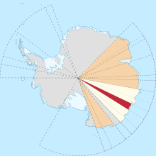
מיקום חוף סברינה (אדום) בארץ וילקס (צהוב) בטריטוריה האנטארקטית האוסטרלית (כתום)
נתונים גאוגרפיים
קואורדינטות 67°20′00″S 119°00′00″E / 67.3333°S 119°E / -67.3333; 119
נתונים מדיניים
לעריכה בוויקינתונים שמשמש מקור לחלק מהמידע בתבנית
תמונת לוויין שצולמה על ידי נאס"א של אזור חוף נוקס, חוף באד, וחוף סברינה

חוף סברינהאנגלית: Sabrina Coast) הוא אזור בארץ וילקס שבאנטארקטיקה[1].

חוף באד מוגדר כאזור החוף של אנטארקטיקה, הממוקם בין כף וולדרון לבין כף סאות'ארד[1].

גילוי החוף

[עריכת קוד מקור | עריכה]

הראשון שראה חוף זה היה ג'ון בלאני ב-3 במרץ[2] 1839[1][2], אשר ראה את החוף (או אזור סמוך לו) ממזרח למיקום החוף - בקו אורך 117 מזרח[1][2].

הראשונים שהתקרבו אל החוף, בפברואר 1840[1], הייתה משלחת החקר של ארצות הברית (שנערכה בין השנים 18381842), בפיקודו של לוטננט צ'ארלס וילקס[1], והאזור מופיע בתרשים שערך וילקס בשנת 1840 - בו הוא מכנה את החוף "רמת טוטן" (Totten High Land)[1].

בשנת 1931[1][2], משלחת החקר הבריטית, אוסטרלית וניו זילנדית לאנטארקטיקה[1][2], בפיקודו של דאגלס מוסון ראתה יבשה בקו רחוב המצוי מעלה מדרום למקום שהתגלה על ידי בלאני ווילקס[1][2].

שמו של האזור ניתן לו על ידי צ'ארלס וילקס[1][2].

וילקס קרא לאזור על שם הספינה הדו-תרנית סברינה (Sabrina)[1][2], אחת מספינותיו של בלאני, אשר טבעה בסופה בשלהי מרץ 1839 (לאחר גילוי החוף)[1][2].

מוסון, מתוך כבוד לוילקס ובלני - השאיר את השם[1][2].

לקריאה נוספת

[עריכת קוד מקור | עריכה]
• Tolotti, Raffaella; Duffy, Meghan; Dove, Isabel; Kendall, Meaghan; Donda, Federica; Romeo, Roberto; Geletti, Riccardo; Caburlotto, Andrea; Armand, Leanne; O'Brien, Phil; Leventer, Amy; De Santis, Laura; Corradi, Nicola, Sabrina Coast (East Antarctica) depositional processes highlighted through stratigraphic and paleoenvironmental diatom analysis, 21st EGU General Assembly, EGU2019, Proceedings from the conference held 7-12 April, 2019 in Vienna, Austria, id.169702
• Aleksandr Montelli, Sean P.S. Gulick, Rodrigo Fernandez, Bruce C. Frederick, Amelia E. Shevenell, Amy Leventer, Donald D. Blankenship, Seismic stratigraphy of the Sabrina Coast shelf, East Antarctica: Early history of dynamic meltwater-rich glaciations, GSA Bulletin 2019;; 132 (3-4): 545–561. doi: https://doi.org/10.1130/B35100.1
• Donda, F., Leitchenkov, G., Brancolini, G., Romeo, R., De Santis, L., Escutia, C., Cotterle, D. (2020), The influence of Totten Glacier on the Late Cenozoic sedimentary record, Antarctic Science, 32(4), 288-300. doi: https:doi:10.1017/S0954102020000188

קישורים חיצוניים

[עריכת קוד מקור | עריכה]

הערות שוליים

[עריכת קוד מקור | עריכה]
{{bottomLinkPreText}} {{bottomLinkText}}
חוף סברינה
Listen to this article

This browser is not supported by Wikiwand :(
Wikiwand requires a browser with modern capabilities in order to provide you with the best reading experience.
Please download and use one of the following browsers:

This article was just edited, click to reload
This article has been deleted on Wikipedia (Why?)

Back to homepage

Please click Add in the dialog above
Please click Allow in the top-left corner,
then click Install Now in the dialog
Please click Open in the download dialog,
then click Install
Please click the "Downloads" icon in the Safari toolbar, open the first download in the list,
then click Install
{{::$root.activation.text}}

Install Wikiwand

Install on Chrome Install on Firefox
Don't forget to rate us

Tell your friends about Wikiwand!

Gmail Facebook Twitter Link

Enjoying Wikiwand?

Tell your friends and spread the love:
Share on Gmail Share on Facebook Share on Twitter Share on Buffer

Our magic isn't perfect

You can help our automatic cover photo selection by reporting an unsuitable photo.

This photo is visually disturbing This photo is not a good choice

Thank you for helping!


Your input will affect cover photo selection, along with input from other users.

X

Get ready for Wikiwand 2.0 🎉! the new version arrives on September 1st! Don't want to wait?