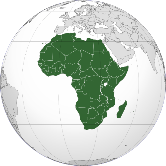
檔案:Africa (orthographic projection).svg

Ngièn-pún tóng-on (SVG文件,尺寸:550×550像素,文件大細:111 KB)
Vùn-khien li̍t-sṳ́
Tiám-khim ngit-khì / sṳ̀-kiên lòi chhà-khon tông-sṳ̀ chhut-hien-ko ke vùn-khien.
| Ngit khì / Sṳ̀-kiên | Suk-lio̍k-thù | Vì-thu | Yung-fu | Yi-kien | |
|---|---|---|---|---|---|
| tông-chhièn | 2022年10月12日 (Sâm) 17:06 |  | 550 × 550(111 KB) | M.Bitton | Reverted to version as of 14:01, 4 September 2022 (UTC): per COM:OVERWRITE |
| 2022年10月12日 (Sâm) 12:05 |  | 550 × 550(113 KB) | Рагин1987 | Socotra Island is geologically part of Africa | |
| 2022年9月4日 (Ngit) 14:01 |  | 550 × 550(111 KB) | M.Bitton | Reverted to version as of 13:07, 20 November 2021 (UTC): per COM:OVERWRITE | |
| 2022年9月4日 (Ngit) 13:54 |  | 550 × 550(115 KB) | Рагин1987 | Correction | |
| 2022年8月31日 (Sâm) 13:30 |  | 2,048 × 2,048(1.01 MB) | Рагин1987 | Small correction (Socotra Island is geologically closer to Africa) | |
| 2021年11月20日 (Liuk) 13:07 |  | 550 × 550(111 KB) | M.Bitton | Reverted to version as of 19:13, 21 November 2020 (UTC): per COM:OVERWRITE. Please don't revert again. | |
| 2021年11月19日 (Ńg) 21:02 |  | 550 × 550(113 KB) | Jacob300 | Reverted to version as of 19:40, 13 October 2021 (UTC) | |
| 2021年10月13日 (Sâm) 22:58 |  | 550 × 550(111 KB) | M.Bitton | Reverted to version as of 19:13, 21 November 2020 (UTC): per Com:Overwrite | |
| 2021年10月13日 (Sâm) 19:40 |  | 550 × 550(113 KB) | Gebagebo | Added Somaliland | |
| 2020年11月21日 (Liuk) 19:13 |  | 550 × 550(111 KB) | Christian Ferrer | Reverted to version as of 18:52, 21 November 2020 (UTC) |
Vùn-khien yung-chhú
Hâ poi ke 64-chak ya̍p-mien lièn-chiap to pún vùn-khien:
- Algeria
- Angola
- Benin
- Botswana
- Burkina Faso
- Burundi
- Cabo Verde
- Cameroon
- Canaria Khiùn-tó
- Chad
- Chhak-tho Guinea
- Chûng-fî Khiung-fò-koet
- Comoros
- Congo Khiung-fò-koet
- Congo Mìn-chú Khiung-fò-koet
- Côte d'Ivoire
- Djibouti
- Eritrea
- Eswatini
- Ethiopia
- Fî-chû
- Gabon
- Gambia
- Ghana
- Guinea
- Guinea-Bissau
- Kenya
- Lesotho
- Liberia
- Libya
- Madagascar
- Madeira
- Malawi
- Mali
- Mauritania
- Mauritius
- Mayotte
- Morocco
- Mozambique
- Namibia
- Niger
- Nigeria
- Nàm-fî
- Nàm Sudan
- Rwanda
- Réunion
- Sahrawi Â-lâ-pak Mìn-chú Khiung-fò-koet
- Saint Helena, Ascension lâu Tristan da Cunha
- Senegal
- Seychelles
- Sierra Leone
- Somalia
- Somaliland
- Sudan
- São Tomé lâu Príncipe
- Sî Sahara
- Tanzania
- Togo
- Tunisia
- Uganda
- Zambia
- Zimbabwe
- Âi-khi̍p
- 模板:Fî-chû
Chhiòn-vet tóng-on sṳ́-yung chhong-khóng
Hâ-lie̍t khì-thâ Wiki chûng sṳ́-yung liá-chak tóng on:
- ab.wikipedia.org ke sṳ́-yung chhong-khóng
- ace.wikipedia.org ke sṳ́-yung chhong-khóng
- ady.wikipedia.org ke sṳ́-yung chhong-khóng
- af.wikipedia.org ke sṳ́-yung chhong-khóng
- Afrika
- Asië
- Bloemfontein
- Botswana
- Europa
- Ghana
- Kaapstad
- Noord-Amerika
- Namibië
- Pretoria
- Suid-Afrika
- Suid-Amerika
- Eswatini
- Zimbabwe
- Zambië
- Gambië
- Mosambiek
- Angola
- Lesotho
- Sierra Leone
- Marokko
- Algerië
- Sjabloon:Kontinente
- Ekwatoriaal-Guinee
- Nigerië
- Demokratiese Republiek die Kongo
- Hoofstad
- Lys van hoofstede
- Sjabloon:Lande van Afrika
- Madagaskar
- Kenia
- Benin
- Burkina Faso
- Burundi
- Comore-eilande
- Soedan
- Rwanda
- Tanzanië
- Uganda
- Gaboen
- Republiek die Kongo
- Malawi
- Somalië
- Harare
- Egipte
- Ethiopië
Kiám-sṳ liá vùn-khien ke kiên-tô chhiòn-vet sṳ́-yung chhong-khóng.
Ngièn sú-kí
Text is available under the CC BY-SA 4.0 license; additional terms may apply.
Images, videos and audio are available under their respective licenses.


