Scarborough (North Yorkshire)
Wikipediasta
| Scarborough | |
|---|---|
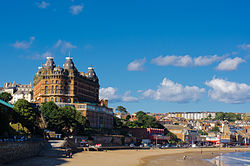
 Grand Hotel Scarboroughin kaupungissa. |
|
 Scarboroughin sijainti Englannissa ja North Yorkshiressä. |
|
|
Koordinaatit: |
|
| Valtio | Yhdistynyt kuningaskunta |
| Osa | Englanti |
| Hallintoalue | Yorkshire ja Humber |
| Kreivikunta | North Yorkshire |
| Hallinto | |
| – Hallinnon tyyppi | Hallintopiiri |
| Piirivaltuusto | 50 paikkaa |
| Pinta-ala | |
| – Kokonaispinta-ala | 14,5 km² |
| – Metropolialue | 817 km² |
| Väkiluku (2017) | 61 525 |
| – Väestötiheys | 4 243 as./km² |
| – Metropolialue | 108 370 |
| – Väestötiheys metropolialue | 133 as./km² |
Scarborough on noin 62 000 asukkaan kaupunki ja 108 000 asukkaan hallintopiiri (borough) North Yorkshiren kreivikunnassa Pohjois-Englannissa.[1][2][3] Hallintopiiri sijaitsee Pohjanmeren rannikolla lähes kokonaisuudessaan North York Moorsin kansallispuiston rajojen sisäpuolella. Eskdale pohjoisessa ja Derwentjoki etelässä halkovat laajoja kanervanummia, joilla on siellä täällä lammastiloja ja uudelleenistutettua metsää. Kallioisella merenrannalla on useita pieniä kalastajakyliä. Suurin osa hallintopiirin väestöstä elää Scarboroughin, Fileyn ja Whitbyn rannikkokaupungeissa.[1]
Scarboroughin kaupungissa oli kristillinen kappeli jo vuonna 1000. Norjan kuninkaan Harald Ankaran sotajoukot tuhosivat sen vuonna 1066.[4] Vanhakaupunki levittäytyy sataman ympärille, ja moderni kaupunki on rakennettu kalkkikivitörmälle 30–70 metriä merenpinnan yläpuolelle. Scarboroughissa on rautatieasema, josta pääsee esimerkiksi Yorkiin. Kaupunki on ollut suosittu lomakohde 360 vuoden ajan.[5] Se on myös tärkeä konferenssipaikka ja eläkeläisten suosima asuinpaikka.[1]
Aiheesta muualla
[muokkaa | muokkaa wikitekstiä] Kuvia tai muita tiedostoja aiheesta Scarborough (North Yorkshire) Wikimedia Commonsissa
Lähteet
[muokkaa | muokkaa wikitekstiä]- ↑ a b c Scarborough Encyclopaedia Britannica. Viitattu 7.4.2019. (englanniksi)
- ↑ Brinkhoff, Thomas: Scarborough (North Yorkshire, Yorkshire and the Humber, United Kingdom) – Population Statistics, Charts, Map and Location City Population. Viitattu 7.4.2019. (englanniksi)
- ↑ Brinkhoff, Thomas: Scarborough (District, North Yorkshire, United Kingdom) – Population Statistics, Charts, Map and Location City Population. Viitattu 7.4.2019. (englanniksi)
- ↑ History Scarborough
- ↑ Yorkshire Coast
Text is available under the CC BY-SA 4.0 license; additional terms may apply.
Images, videos and audio are available under their respective licenses.
