رودخانه کلرادو
| رودخانه کلرادو | |
 | |
| کشور | United States، Mexico |
|---|---|
| ایالت | Colorado، Utah، Arizona، Nevada، California، Baja California، Sonora |
| رودهای فرعی | |
| - چپ | Fraser River، Blue River، Eagle River، Roaring Fork River، Gunnison River، Dolores River، San Juan River، Little Colorado River، Bill Williams River، Gila River |
| - راست | رود گرین (رود کلرادو)، Dirty Devil River، Escalante River، Kanab River، Virgin River، Hardy River |
| شهرها | گلنوود اسپرینگز، کلرادو، گراند جانکشن، کلرادو، مواب، یوتا، پیج، بولهد سیتی، آریزونا، لیک هاواسو سیتی، آریزونا، یوما، آریزونا، سن لوئیس ریو کلرادو |
| سرچشمه | La Poudre Pass |
| - موقعیت | رشتهکوه راکی, کلرادو, ایالات متحده آمریکا |
| - ارتفاع | ۱۰۱۸۴ فوت (۳٬۱۰۴ متر) |
| - مختصات | ۴۰°۲۸′۲۰″ شمالی ۱۰۵°۴۹′۳۴″ غربی / ۴۰٫۴۷۲۲۲°شمالی ۱۰۵٫۸۲۶۱۱°غربی |
| دهانه رود | خلیج کالیفرنیا |
| - موقعیت | Colorado River Delta, باخا کالیفرنیا–ایالت سونورا, مکزیک |
| - ارتفاع | ۰ فوت (۰ متر) |
| - مختصات | ۳۱°۵۴′۰۰″ شمالی ۱۱۴°۵۷′۰۳″ غربی / ۳۱٫۹۰۰۰۰°شمالی ۱۱۴٫۹۵۰۸۳°غربی |
| طول | ۱٬۴۵۰ مایل (۲٬۳۳۴ کیلومتر) |
| حوزه | ۲۴۶۰۰۰ مایلمربع (۶۳۷٬۱۳۷ کیلومترمربع) |
| تخلیه | for mouth (average virgin flow), max and min at Topock, AZ, ۳۰۰ مایل (۴۸۰ کیلومتر) from the mouth |
| - میانگین | ۲۲٬۵۰۰ cu ft/s (۶۳۷ m3/s) |
| - حداکثر | ۳۸۴٬۰۰۰ cu ft/s (۱۰٬۹۰۰ m3/s) [۱] |
| - حداقل | ۴۲۲ cu ft/s (۱۲ m3/s) |
 موقعیت رودخانه کلرادو در نقشه
| |
| ویکیانبار: Colorado River | |
رودخانه کلرادو (به انگلیسی: Colorado river) از رودخانههای بلند ایالات متحده آمریکا و رودخانهایست که از گرند کنیون میگذرد.
این رودخانه از دو کشور مکزیک و آمریکا و از پنج ایالت یوتا، آریزونا، نوادا، کلرادو و کالیفرنیا عبور میکند و مهمترین رودخانه ایالات متحده جنوب غربی و مکزیک شمال غربی محسوب میشود. سد هوور بر روی این رودخانه، در مرز نوادا و آریزونا و در چند کیلومتری شرق لاس وگاس ساخته شدهاست. سد گلن کنیون نیز بر روی همین رودخانه بسته شدهاست.
در زبان بومی سرخپوستان منطقه، به این رودخانه «'Aha Kwahwat» میگویند.
این رودخانه ۲۳۰۰ کیلومتر طول داشته و به خلیج کالیفرنیا میریزد.
سرچشمه این رودخانه در ارتفاعات پارک ملی کوه راکی میباشد.
نگارخانه
[ویرایش]-
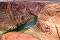
 " پیچ نعل اسبی در غرب گراند کنیون
 -
 نمایی از رودخانه کلرادو در شمال شرقی منطقه گراند کنیون


پیوند به بیرون
[ویرایش]موضوعات ایالات متحده آمریکا | ||||||||
|---|---|---|---|---|---|---|---|---|
| تاریخ |
| |||||||
| دولت | ||||||||
| دیپلماسی | اختلافات سیاسی • احزاب سیاسی (حزب دموکرات • حزب جمهوریخواه • دیگر احزاب) • انتخابات (مجمع انتخاباتی) • ایدئولوژی • رسواییهای سیاسی • ایالتهای قرمز و ایالتهای آبی • عمو سام • موقعیت سیاسی پورتو ریکو | |||||||
| جغرافیا | قلمرو • ایالات • شهرها • شهرستان • مناطق جغرافیایی و فرهنگی (نیو انگلند • ایالتهای ساحلی اقیانوس اطلس • ایالتهای جنوبی • ایالتهای غرب میانه • دشت های بزرگ • آبشارها • ایالتهای شمال غرب • ایالتهای جنوب غربی) • کوهها (رشتهکوه آپالیشین • رشتهکوه راکی) • رودخانهها (رودخانه میسیسیپی • رودخانه میسوری • رودخانه کانزاس • رودخانه کلرادو) • فهرست جزایر ایالات متحده آمریکا • نقاط مرزی • پارکهای ملی • آب و فاضلاب | |||||||
| اقتصاد | دلار آمریکا • کشاورزی • شرکتها • وال استریت • سامانه ذخیره فدرال • بانکداری • بیمه • سطح زندگی در ایالات متحده آمریکا (درآمد شخصی • درآمد خانوار • نابرابری درآمد • مالکیت مسکن) • ارتباطات • حمل ونقل (خودروهای شخصی • حمل و نقل سنگین • شبکه بزرگراههای بین ایالتی • بزرگراهها • فرودگاهها • مسیرهای ریلی) • گردشگری | |||||||
| جامعه | جمعیت • زبانها (انگلیسی • اسپانیایی) • مردم • مذهب • طبقات اجتماعی (رویای آمریکایی • فراوانی • طبقه متوسط • فقر • آموزش عالی) • رسانه • ورزش • آموزش • تعطیلات رسمی • تبه کاری • زندانها • مراقبتهای بهداشتی • بیمههای درمانی | |||||||
| فرهنگ | موسیقی (کلاسیک • فولکلور • موسیقی مردمی • جاز) • تلویزیون\سینما (هالیوود) • رادیو • ادبیات (فولکلورها • شعر • تعالیگرایی • رنسانس هارلم • نسل بیت) • هنرهای تجسمی (اکپرسیونیسم انتزاعی) • آشپزی • رقص • معماری • مد • پرچم | |||||||
| دیگر موضوعات | سقط جنین • بلوغ جنسی • قانون تبعیض مثبت • استثناگرایی آمریکایی • آمریکاستیزی • اعدام • سیاست مواد مخدر\ممنوعیت الکل (مناطق خشک الکلی) • انرژی • محیط زیست • اسلحه • مراکز پزشکی • حقوق • مهاجرت (حصار مرزی آمریکا-مکزیک) • چاقی • نژادپرستی • ازدواج همجنسگرایان | |||||||
سیستم رودخانههای کلرادو | |||||||||
|---|---|---|---|---|---|---|---|---|---|
| حوضهها |
|     | |||||||
| درهها |
| ||||||||
| ویژگیهای طبیعی |
| ||||||||
| شاخههای فرعی |
| ||||||||
| مهندسی |
| ||||||||
| تعیین مناطق |
| ||||||||
| مباحث مرتبط |
| ||||||||
- ↑ Wiltshire, Gilbert & Rogers 2010, p. 102.
Text is available under the CC BY-SA 4.0 license; additional terms may apply.
Images, videos and audio are available under their respective licenses.
Cover photo is available under {{::mainImage.info.license.name || 'Unknown'}} license.
Cover photo is available under {{::mainImage.info.license.name || 'Unknown'}} license.
Credit:
(see original file).
