Roudná
| Por aliaj signifoj, bv. rigardi la apartigilan paĝon: Roudná (apartigilo) |
| Roudná | |||
| germane Raudna | |||
| municipo | |||
 Kapelo en municipo Roudná
| |||
|
|||
| Oficiala nomo: Roudná | |||
| Ŝtato | |||
|---|---|---|---|
| Regiono | Sudbohemia regiono | ||
| Distrikto | Distrikto Tábor | ||
| Administra municipo | Soběslav | ||
| Historia regiono | Bohemio | ||
| Montaro | Tabora montetaro | ||
| Rivero | Lužnice | ||
| Situo | Roudná | ||
| - alteco | 400 m s. m. | ||
| - koordinatoj | 49° 18′ 16″ N 14° 43′ 07″ O / 49.30444 °N, 14.71861 °O (mapo) | ||
| Katastro | 3,65 km² (365 ha) Roudná nad Lužnicí | ||
| Loĝantaro | 582 (2024) | ||
| Denseco | 159,45 loĝ./km² | ||
| Unua skribmencio | 1381 | ||
| Horzono | MET (UTC+1) | ||
| - somera tempo | MET (UTC+2) | ||
| Poŝtkodo | 392 01 | ||
| NUTS 3 | CZ031 | ||
| NUTS 4 | CZ0317 | ||
| NUTS 5 | CZ0317 553018 | ||
| Katastraj teritorioj | 1 | ||
| Partoj de municipo | 2 | ||
| Bazaj setlejunuoj | 2 | ||
  Situo enkadre de Ĉeĥio
| |||
| Retpaĝo: www.obecroudna.cz | |||


Roudná (germane Raudna) estas municipo de Ĉeĥio troviĝanta en distrikto Tábor, en Sudbohemia regiono proksimume 5 km sude de Planá nad Lužnicí. En 2024 ĉi tie vivis 582 loĝantoj. Okcidente de Roudná trafluas direkte al nordoriento rivero Lužnice. Roudná estas ankaŭ nomo de stacio sur fervojlinio Prago – České Budějovice.
La najbaraj municipoj de la setlejo estas Košice, Klenovice, Skalice, Sedlečko u Soběslavě kaj Myslkovice.
Historio
[redakti | redakti fonton]La unua skribmencio pri la municipo devenas el la jaro 1381.
Loĝantaro
[redakti | redakti fonton]Evoluo de nombro de loĝantoj
La datoj devenas el datumbazo de Vikidatumoj
| Jaro | Loĝantoj |
|---|---|
| 1869 | 548 |
| 1880 | 455 |
| 1890 | 393 |
| 1900 | 393 |
| 1910 | 370 |
| 1921 | 360 |
| Jaro | Loĝantoj |
|---|---|
| 1930 | 464 |
| 1950 | 498 |
| 1961 | 533 |
| 1970 | 533 |
| 1980 | 503 |
| 1991 | 496 |
| Jaro | Loĝantoj |
|---|---|
| 2001 | 520 |
| 2011 | 514 |
| 2014 | 529 |
| 2016 | 531 |
| 2017 | 529 |
| 2018 | 542 |
| Jaro | Loĝantoj |
|---|---|
| 2019 | 550 |
| 2020 | 552 |
| 2021 | 547 |
| 2022 | 569 |
| 2023 | 580 |
| 2024 | 582 |
Partoj de municipo
[redakti | redakti fonton]- Roudná
- Janov
Memorindaĵoj
[redakti | redakti fonton]- Kapelo sur vojkruciĝo de ŝoseoj kondukantaj al municipoj Janov kaj Planá nad Lužnicí
- Monumento al viktimoj de la mondmilitoj
Personecoj
[redakti | redakti fonton]Fine de sia vivo ĉi tie vivis kaj mortis Jindřich Kàan z Albestů.
Pluaj fotoj
[redakti | redakti fonton]-
 Konstruaĵo n-ro 5
 -
 Vendejo
 -
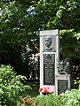 Monumento al viktimoj
 -
 Fervoja ponto


| ||||
Text is available under the CC BY-SA 4.0 license; additional terms may apply.
Images, videos and audio are available under their respective licenses.
Cover photo is available under {{::mainImage.info.license.name || 'Unknown'}} license.
Cover photo is available under {{::mainImage.info.license.name || 'Unknown'}} license.
Credit:
(see original file).
