Lípa (distrikto Zlín)
| Por aliaj signifoj, bv. rigardi la apartigilan paĝon: Lípa |
| Lípa | |||
| municipo | |||
 Municipo Lípa
| |||
|
|||
| Oficiala nomo: Lípa | |||
| Ŝtato | |||
|---|---|---|---|
| Regiono | Regiono Zlín | ||
| Distrikto | Distrikto Zlín | ||
| Administra municipo | Zlín | ||
| Historia regiono | Moravio | ||
| Montaro | Vizovica montetaro | ||
| Rivero | Dřevnice | ||
| Situo | Lípa | ||
| - alteco | 249 m s. m. | ||
| - koordinatoj | 49° 12′ 55″ N 17° 46′ 07″ O / 49.21528 °N, 17.76861 °O (mapo) | ||
| Katastro | 8,34 km² (834 ha) Lípa nad Dřevnicí | ||
| Loĝantaro | 857 (2024) | ||
| Denseco | 102,76 loĝ./km² | ||
| Unua skribmencio | 1261 | ||
| Horzono | MET (UTC+1) | ||
| - somera tempo | MET (UTC+2) | ||
| Poŝtkodo | 763 11 | ||
| NUTS 3 | CZ072 | ||
| NUTS 4 | CZ0724 | ||
| NUTS 5 | CZ0724 549622 | ||
| Katastraj teritorioj | 1 | ||
| Partoj de municipo | 1 | ||
| Bazaj setlejunuoj | 2 | ||
  Situo enkadre de Ĉeĥio
| |||
| Retpaĝo: www.obeclipa.cz | |||


Lípa estas municipo en Ĉeĥio troviĝanta en distrikto Zlín, en Regiono Zlín. Centro de la municipo situas preter rivereto Dřevnice en alteco 250 m s. m. Vivas ĉi tie 857 loĝantoj (2024).
La najbaraj municipoj de la setlejo estas Zádveřice-Raková, Horní Lhota, Želechovice nad Dřevnicí kaj Zlín.
Historio
[redakti | redakti fonton]La unua skribmencio pri la vilaĝo devenas el la jaro 1261.
En la jaroj 1961–1976 ĝi estis konsisto de municipo Želechovice nad Dřevnicí kaj ĝi fariĝis komune kun ĝi konsisto de urbo Zlín. Tute ĝi memstariĝis la 24-an de novembro 1990.
Loĝantaro
[redakti | redakti fonton]Evoluo de nombro de loĝantoj
La datoj devenas el datumbazo de Vikidatumoj
| Jaro | Loĝantoj |
|---|---|
| 1869 | 630 |
| 1880 | 638 |
| 1890 | 622 |
| 1900 | 705 |
| 1910 | 693 |
| 1921 | 738 |
| Jaro | Loĝantoj |
|---|---|
| 1930 | 864 |
| 1950 | 859 |
| 1961 | 895 |
| 1970 | 866 |
| 1980 | 730 |
| 1991 | 657 |
| Jaro | Loĝantoj |
|---|---|
| 2001 | 629 |
| 2014 | 783 |
| 2016 | 831 |
| 2017 | 847 |
| 2018 | 861 |
| 2019 | 866 |
| Jaro | Loĝantoj |
|---|---|
| 2020 | 861 |
| 2021 | 828 |
| 2022 | 840 |
| 2023 | 882 |
| 2024 | 857 |
Memorindaĵoj
[redakti | redakti fonton]- Kapelo
- Konstruaĵo de municipa ofico kaj Infanĝardeno
- Muelejo n-ro 18
Pluaj fotoj
[redakti | redakti fonton]-
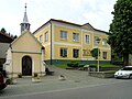 Kapelo kaj municipa ofico
 -
 Gastejo U Kubíků
 -
 Fajroestingista armilejo
 -
 Fervoja stacio

,_hospoda_U_Kub%C3%ADk%C5%AF.jpg)
,_hasi%C4%8Dsk%C3%A1_zbrojnice.jpg)
.jpg)
Text is available under the CC BY-SA 4.0 license; additional terms may apply.
Images, videos and audio are available under their respective licenses.
Cover photo is available under {{::mainImage.info.license.name || 'Unknown'}} license.
Cover photo is available under {{::mainImage.info.license.name || 'Unknown'}} license.
Credit:
(see original file).
