Hradčovice
| Hradčovice | |||
| municipo | |||
 Preĝejo de Ĉiuj sanktuloj
| |||
|
|||
| Oficiala nomo: Hradčovice | |||
| Ŝtato | |||
|---|---|---|---|
| Regiono | Regiono Zlín | ||
| Distrikto | Distrikto Uherské Hradiště | ||
| Administra municipo | Uherský Brod | ||
| Historiaj regionoj | Grandmoravia regno, Moravio | ||
| Montaro | Vizovica montetaro | ||
| Rivero | Olšava | ||
| Situo | Hradčovice | ||
| - alteco | 198 m s. m. | ||
| - koordinatoj | 49° 02′ 59″ N 17° 34′ 56″ O / 49.04972 °N, 17.58222 °O (mapo) | ||
| Areo | 9,27 km² (927 ha) | ||
| Loĝantaro | 980 (2024) | ||
| Denseco | 105,72 loĝ./km² | ||
| Unua skribmencio | 1247 | ||
| Horzono | MET (UTC+1) | ||
| - somera tempo | MET (UTC+2) | ||
| Poŝtkodo | 687 33 | ||
| NUTS 3 | CZ072 | ||
| NUTS 4 | CZ0722 | ||
| NUTS 5 | CZ0722 592200 | ||
| Katastraj teritorioj | 2 | ||
| Partoj de municipo | 2 | ||
| Bazaj setlejunuoj | 2 | ||
  Situo enkadre de Ĉeĥio
| |||
| Retpaĝo: www.hradcovice.cz | |||


Hradčovice estas municipo en Ĉeĥio, en Regiono Zlín, en distrikto Uherské Hradiště. Ĝi situas en valo sur milda deklivo, sur la dekstra flanko de bordo de rivero Olšava, proksimume 6 km okcidente de la plej proksima urbo Uherský Brod. Vivas ĉi tie 980 loĝantoj (2024).
La najbaraj municipoj de la setlejo estas Mistřice, Popovice, Veletiny, Nedachlebice kaj Drslavice.
Historio
[redakti | redakti fonton]La unua skribmencio pri la vilaĝo estas el la jaro 1247.
Loĝantaro
[redakti | redakti fonton]Evoluo de nombro de loĝantoj
La datoj devenas el datumbazo de Vikidatumoj
| Jaro | Loĝantoj |
|---|---|
| 1869 | 760 |
| 1880 | 847 |
| 1890 | 946 |
| 1900 | 978 |
| 1910 | 1 104 |
| 1921 | 1 135 |
| Jaro | Loĝantoj |
|---|---|
| 1930 | 1 094 |
| 1950 | 1 060 |
| 1961 | 1 165 |
| 1970 | 1 137 |
| 1980 | 1 026 |
| 1991 | 1 020 |
| Jaro | Loĝantoj |
|---|---|
| 2001 | 969 |
| 2014 | 1 015 |
| 2016 | 1 021 |
| 2017 | 1 030 |
| 2018 | 1 025 |
| 2019 | 1 017 |
| Jaro | Loĝantoj |
|---|---|
| 2020 | 1 013 |
| 2021 | 958 |
| 2022 | 988 |
| 2023 | 984 |
| 2024 | 980 |
Partoj de municipo
[redakti | redakti fonton]- Hradčovice
- Lhotka
Memorindaĵoj
[redakti | redakti fonton]- Preĝejo de Ĉiuj sanktuloj
- Gastejo el la jaro 1416
- Naturrezervejo Rovná hora
Pluaj fotoj
[redakti | redakti fonton]-
 Poŝto
Poŝto -
 Centro de la municipo
 -
 Hradčovice, penziono
 -
 Alveturejo ĝis Hradčovice de Uherský Brod
 -
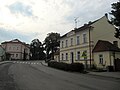
 Strato


| ||||
Text is available under the CC BY-SA 4.0 license; additional terms may apply.
Images, videos and audio are available under their respective licenses.
Cover photo is available under {{::mainImage.info.license.name || 'Unknown'}} license.
Cover photo is available under {{::mainImage.info.license.name || 'Unknown'}} license.
Credit:
(see original file).
