Khvalynsk Hills
| Khvalynsk Hills | |
|---|---|
| Хвалынские горы | |
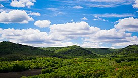
 Panorama of the Khvalynsk Mountains. | |
| Highest point | |
| Peak | Unnamed |
| Elevation | 369 m (1,211 ft) |
| Geography | |
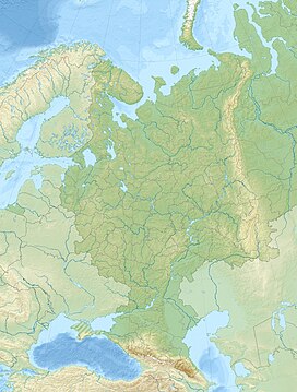
| Location | Saratov Oblast, Penza Oblast, Russia |
| Range coordinates | 52°29′N 48°01′E / 52.483°N 48.017°E[1] |
| Parent range | Volga Uplands |
| Geology | |
| Age of rock | Cretaceous |
| Climbing | |
| Easiest route | From Khvalynsk |
Khvalynsk Hills (Russian: Хвалынские горы) is a hilly region in Saratov Oblast and Penza Oblast, Russia.
A 25,524 hectares (63,070 acres) sector of the hills is a protected area under the name Khvalynsky National Park, which was established in 1994.[2]
Geography
[edit]The Khvalynsk Mountains are a group of smooth hills in the East European Plain, extending on the right bank of the Volga. They are one of the highest of the subranges of the Volga Uplands.[3][2] They are mostly located in the Saratov Oblast, with a small part in southeastern Penza Oblast. The hill zone is sparsely populated. Villages such as Pikhankino (Пиксанкино), Novaya Yaksarka (Новая Яксарка), Staraya Yaksarka (Старая Яксарка), Novy Machim (Новый Мачим), Russkaya Norka (Русская Норка), Mordovskaya Norka (Мордовская Норка), Rango Lisma (Ранго-Лисьма), Vilyayevka (Виляевка), Ivanovka (Ивановка —Шемышейский район), Yango-Prya (Янго-Пря), Ust-Murza (Усть-Мурза), Vorobyovka (Воробьёвка —Шемышейский район), Azrapino (Азрапино —Пензенская область), Naumkino (Наумкино —Пензенская область), Dubrovka-on-Uze (Дубровка-на-Узе), Staroye Zakharkino (Старое Захаркино), Staroye Demkino (Старое Демкино), Ust-Uza (Усть-Уза), Peschanka (Песчанка —Шемышейский район), Aleksandro-Bogdanovka (Александро-Богдановка), Koldais (Колдаис), Neklyudovo (Неклюдово —Пензенская область), Karzhimant (Каржимант), Arapino (Арапино) and Neverkino, are scattered throughout the hill area, but cities are only found in the periphery.
The highest point of Saratov Oblast, reaching 369 metres (1,211 ft), as well as the highest point of Penza Oblast, reaching 342 metres (1,122 ft) above sea level, are located in the Khvalinsk Hills. Both summits are unnamed.[4] There are also white chalk hills among pine forests that are a tourist attraction.[5]
 |
 |
See also
[edit]References
[edit]- ^ Google Earth
- ^ a b Хвалынский национальный парк
- ^ ПРИВО́ЛЖСКАЯ ВОЗВЫ́ШЕННОСТЬ Archived 2021-11-22 at the Wayback Machine Great Russian Encyclopedia. (in Russian)
- ^ National Park of Khvalynsk and its Natural Trails
- ^ Хвалынские меловые горы - Туристический Саратов
External links
[edit] Media related to Khvalynsk Mountains at Wikimedia Commons
- Хвалынский район - Большая Саратовская Энциклопедия
Text is available under the CC BY-SA 4.0 license; additional terms may apply.
Images, videos and audio are available under their respective licenses.


