Volga Upland
| Volga Upland | |
|---|---|
| Приволжская возвышенность | |
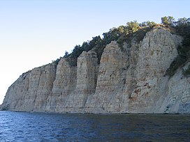
 Stolbichi wall on the banks of the Volga | |
| Highest point | |
| Peak | Unnamed |
| Elevation | 381 m (1,250 ft) |
| Dimensions | |
| Length | 800 km (500 mi) NNE/SSW |
| Width | 500 km (310 mi) ESE/WNW |
| Geography | |
| Location | Nizhny Novgorod Oblast, Mordovia, Chuvashia, Tatarstan, Penza Oblast, Ulyanovsk Oblast, Samara Oblast, Saratov Oblast, Volgograd Oblast, Russia |
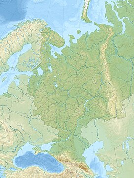
| Range coordinates | 53°07′N 46°36′E / 53.117°N 46.600°E[1] |
| Parent range | East European Plain |
| Geology | |
| Age of rock | Carboniferous, Cretaceous |
| Type of rock | Limestones, dolomite, sandstone, chalk |
The Volga Upland, also known as the Volga Uplands, Volga Hills,[2] or Volga Plateau (Приволжская возвышенность), is a vast region of the East European Plain in the European part of Russia that lies west of the Volga River and east of the Central Russian Upland.[3]
The uplands lie in the cool continental climate zone, characterised by large fluctuations in seasonal temperatures and generally little rainfall. Outside of the cities in the region, population density is generally between 28 and 129 inhabitants per square mile.
Geography
[edit]The uplands run for approximately 800 kilometres (500 mi) in a southwest-northeasterly direction from Volgograd to Kazan. The Tsimlyansk Reservoir lies at the southwestern end of the Volga Upland, with the Kuybyshev Reservoir at the northeastern end.
The landscape on the Volga Uplands is hilly, and several rivers have cut into it, such as the Khopyor, Medveditsa and the Sura. The Volga–Don Canal cuts through the lowlands between the Volga Uplands to the north and the adjacent Yergeni Hills to the south.
The Volga Uplands themselves are rather sparsely populated, but along their edges and in particular along the banks of the Volga there are several large cities, such as (from north to south) Kazan, Ulyanovsk, Saransk, Penza, Syzran, Saratov and Volgograd.[4]
Subranges
[edit]The hill ranges along the Volga banks are traditionally called mountains (горы), despite being of low height. The main ones are:
- Uslon Mountains
- Yuryevy Mountains
- Bogorodskye Mountains
- Syukeyevo Mountains
- Tetyushi Mountains
- Undory Mountains
- Zhiguli Mountains
- Khvalynsk Mountains
- Don-Medveditsa Ridge
See also
[edit]References
[edit]- ^ Google Earth
- ^ "Volga Hills." Columbia Gazetteer of the World Online. 2009. Columbia University Press. 06 Feb. 2009. [1]
- ^ "Приволжская возвышенность". Great Soviet Encyclopedia.
- ^ DK Publishing (1999). Millennium World Atlas. DK. p. xxix, 229. ISBN 978-0-7894-4604-6
External links
[edit] Media related to Volga Upland at Wikimedia Commons
Text is available under the CC BY-SA 4.0 license; additional terms may apply.
Images, videos and audio are available under their respective licenses.


