Zugarramurdi
aus Wikipedia, der freien Enzyklopädie
| Gemeinde Zugarramurdi | |||
|---|---|---|---|

| |||
| Wappen | Karte von Spanien | ||

|
| ||
| Basisdaten | |||
| Land: | |||
| Autonome Gemeinschaft: | |||
| Provinz: | Navarra | ||
| Comarca: | Baztan-Bidasoa | ||
| Gerichtsbezirk: | Pamplona | ||
| Koordinaten: | 43° 16′ N, 1° 33′ W | ||
| Höhe: | 205 msnm | ||
| Fläche: | 5,46 km² | ||
| Einwohner: | 202 (1. Jan. 2022)[1] | ||
| Bevölkerungsdichte: | 37 Einw./km² | ||
| Postleitzahl(en): | 31710 | ||
| Gemeindenummer (INE): | 31264 | ||
| Verwaltung | |||
| Bürgermeisterin: | Evaristo Mentaberri Mihura | ||
| Website: | Zugarramurdi | ||
| Lage des Ortes | |||
Karte anzeigen  | |||

Zugarramurdi ist eine spanische Gemeinde (municipio) in der Comunidad Foral de Navarra mit 202 Einwohnern (1. Januar 2022). neben dem Hauptort Zugarramurdi besteht die Gemeinde aus den Ortschaften Echartea, Madaria und Olazur sowie aus der Wüstung Azcar.
Lage
[Bearbeiten | Quelltext bearbeiten]Zugarramurdi liegt etwa 52 Kilometer nördlich von Pamplona (Iruna) in einer Höhe von ca. 205 m nahe der Grenze zu Frankreich.
Bevölkerungsentwicklung der Gemeinde
[Bearbeiten | Quelltext bearbeiten]
Sehenswürdigkeiten
[Bearbeiten | Quelltext bearbeiten]- Zugarramurdi-Höhlen
- Kirche Mariä Himmelfahrt
- Marienkapelle
-
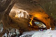 Zugarramurdi-Höhle
 -
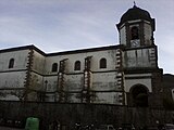 Kirche Mariä Himmelfahrt


Einzelnachweise
[Bearbeiten | Quelltext bearbeiten]- ↑ Cifras oficiales de población de los municipios españoles en aplicación de la Ley de Bases del Régimen Local (Art. 17). Instituto Nacional de Estadística (Bevölkerungsstatistiken des Instituto Nacional de Estadística, Stand 1. Januar 2022).
Weblinks
[Bearbeiten | Quelltext bearbeiten]Abáigar | Abárzuza | Abaurregaina | Abaurrepea | Aberin | Ablitas | Adiós | Aguilar de Codés | Aibar | Allín | Allo | Alsasua | Améscoa Baja | Ancín | Andosilla | Ansoáin | Anue | Añorbe | Aoiz | Araitz | Arakil | Aranarache | Aranguren | Arano | Arantza | Aras | Arbizu | Arce | Los Arcos | Arellano | Areso | Arguedas | Aria | Aribe | Armañanzas | Arróniz | Arruazu | Artajona | Artazu | Atez | Auritz | Ayegui | Azagra | Azuelo | Bakaiku | Barañáin | Barásoain | Barbarin | Bargota | Barillas | Basaburua | Baztan | Beintza-Labaien | Beire | Belascoáin | Bera | Berbinzana | Beriáin | Berrioplano | Berriozar | Bertizarana | Betelu | Bidaurreta | Biurrun-Olcoz | Buñuel | Burgui | Burlada | El Busto | Cabanillas | Cabredo | Cadreita | Caparroso | Cárcar | Carcastillo | Cascante | Cáseda | Castejón | Castillonuevo | Cintruénigo | Cirauqui | Ciriza | Cizur | Corella | Cortes | Desojo | Dicastillo | Donamaria | Doneztebe | Echarri | Egüés | Elgorriaga | Enériz | Eratsun | Ergoiena | Erro | Eslava | Esparza de Salazar | Espronceda | Estella | Esteribar | Etayo | Etxalar | Etxarri Aranatz | Etxauri | Eulate | Ezcabarte | Ezcároz | Ezkurra | Ezprogui | Falces | Fitero | Fontellas | Funes | Fustiñana | Galar | Gallipienzo | Gallués | Garaioa | Garde | Garínoain | Garralda | Genevilla | Goizueta | Goñi | Güesa | Guesálaz | Guirguillano | Hiriberri | Huarte | Ibargoiti | Igantzi | Igúzquiza | Imotz | Irañeta | Irurtzun | Isaba | Ituren | Iturmendi | Iza | Izagaondoa | Izalzu | Jaurrieta | Javier | Juslapeña | Lakuntza | Lana | Lantz | Lapoblación | Larraga | Larraona | Larraun | Lazagurría | Leache | Legarda | Legaria | Leiza | Lekunberri | Leoz | Lerga | Lerín | Lesaka | Lezáun | Liédena | Lizoain | Lodosa | Lónguida | Lumbier | Luquin | Luzaide | Mañeru | Marañón | Marcilla | Mélida | Mendavia | Mendaza | Mendigorría | Metauten | Milagro | Mirafuentes | Miranda de Arga | Monreal | Monteagudo | Morentin | Mues | Murchante | Murieta | Murillo el Cuende | Murillo el Fruto | Muruzábal | Navascués | Nazar | Noáin | Obanos | Ochagavía | Oco | Odieta | Oitz | Oláibar | Olazti | Olejua | Olite | Ollo | Olóriz | Olza | Orbaizeta | Orbara | Orísoain | Orkoien | Oronz | Oroz-Betelu | Orreaga | Oteiza | Pamplona | Peralta | Petilla de Aragón | Piedramillera | Pitillas | Puente la Reina | Pueyo | Ribaforada | Romanzado | Roncal | Sada | Saldias | Salinas de Oro | San Adrián | San Martín de Unx | Sangüesa | Sansol | Santacara | Sarriés | Sartaguda | Sesma | Sorlada | Sunbilla | Tafalla | Tiebas-Muruarte de Reta | Tirapu | Torralba del Río | Torres del Río | Tudela | Tulebras | Úcar | Uharte Arakil | Ujué | Ultzama | Unciti | Unzué | Urdazubi | Urdiain | Urraúl Alto | Urraúl Bajo | Urrotz | Urroz-Villa | Urzainqui | Uterga | Uztárroz | Valtierra | Viana | Vidángoz | Villafranca | Villamayor de Monjardín | Villatuerta | Villava | Yerri | Yesa | Zabalza | Ziordia | Zizur Mayor | Zubieta | Zugarramurdi | Zúñiga
Text is available under the CC BY-SA 4.0 license; additional terms may apply.
Images, videos and audio are available under their respective licenses.
