Murillo el Cuende
aus Wikipedia, der freien Enzyklopädie
| Gemeinde Murillo el Cuende | |||
|---|---|---|---|
| Wappen | Karte von Spanien | ||

|
| ||
| Basisdaten | |||
| Land: | |||
| Autonome Gemeinschaft: | |||
| Provinz: | Navarra | ||
| Comarca: | Erdialdea | ||
| Gerichtsbezirk: | Tafalla | ||
| Koordinaten: | 42° 21′ N, 1° 36′ W | ||
| Höhe: | 350 msnm | ||
| Fläche: | 58,72 km² | ||
| Einwohner: | 664 (1. Jan. 2022)[1] | ||
| Bevölkerungsdichte: | 11 Einw./km² | ||
| Postleitzahl(en): | 31391 | ||
| Gemeindenummer (INE): | 31178 | ||
| Verwaltung | |||
| Bürgermeister: | Itziar Malón Caspe (PSOE) | ||
| Website: | Murillo el Cuende | ||
| Lage des Ortes | |||
Karte anzeigen  | |||

Murillo el Cuende (baskisch Murelu Konde) ist ein Ort und eine Gemeinde (Municipio) in der Comunidad Foral Navarra in Nordspanien mit 664 Einwohnern (Stand: 1. Januar 2022). Neben der gleichnamigen Ortschaft Murillo el Cuende gehören die Ortschaften Rada und Traibuenas zur Gemeinde.
Lage
[Bearbeiten | Quelltext bearbeiten]Murillo el Cuende liegt etwa 62 km südlich von Pamplona in einer Höhe von ca. 350 m. Der Río Aragón durchschneidet die Gemeinde in ostwestlicher Richtung.
Bevölkerungsentwicklung der Gemeinde
[Bearbeiten | Quelltext bearbeiten]
Sehenswürdigkeiten
[Bearbeiten | Quelltext bearbeiten]- Fideskirche (Iglesia de Santa Fe) in Murillo el Cuende
- Johannes-der-Täufer-Kirche in Traibuenas
- Kreuzkapelle in Murillo el Cuende
-
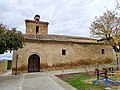 Fideskirche
 -
 Johannes-der-Täufer-Kirche
 -
 Kreuzkapelle
 -
 Rathaus
.jpg)

.jpg)

Weblinks
[Bearbeiten | Quelltext bearbeiten]Einzelnachweise
[Bearbeiten | Quelltext bearbeiten]- ↑ Cifras oficiales de población de los municipios españoles en aplicación de la Ley de Bases del Régimen Local (Art. 17). Instituto Nacional de Estadística (Bevölkerungsstatistiken des Instituto Nacional de Estadística, Stand 1. Januar 2022).
Abáigar | Abárzuza | Abaurregaina | Abaurrepea | Aberin | Ablitas | Adiós | Aguilar de Codés | Aibar | Allín | Allo | Alsasua | Améscoa Baja | Ancín | Andosilla | Ansoáin | Anue | Añorbe | Aoiz | Araitz | Arakil | Aranarache | Aranguren | Arano | Arantza | Aras | Arbizu | Arce | Los Arcos | Arellano | Areso | Arguedas | Aria | Aribe | Armañanzas | Arróniz | Arruazu | Artajona | Artazu | Atez | Auritz | Ayegui | Azagra | Azuelo | Bakaiku | Barañáin | Barásoain | Barbarin | Bargota | Barillas | Basaburua | Baztan | Beintza-Labaien | Beire | Belascoáin | Bera | Berbinzana | Beriáin | Berrioplano | Berriozar | Bertizarana | Betelu | Bidaurreta | Biurrun-Olcoz | Buñuel | Burgui | Burlada | El Busto | Cabanillas | Cabredo | Cadreita | Caparroso | Cárcar | Carcastillo | Cascante | Cáseda | Castejón | Castillonuevo | Cintruénigo | Cirauqui | Ciriza | Cizur | Corella | Cortes | Desojo | Dicastillo | Donamaria | Doneztebe | Echarri | Egüés | Elgorriaga | Enériz | Eratsun | Ergoiena | Erro | Eslava | Esparza de Salazar | Espronceda | Estella | Esteribar | Etayo | Etxalar | Etxarri Aranatz | Etxauri | Eulate | Ezcabarte | Ezcároz | Ezkurra | Ezprogui | Falces | Fitero | Fontellas | Funes | Fustiñana | Galar | Gallipienzo | Gallués | Garaioa | Garde | Garínoain | Garralda | Genevilla | Goizueta | Goñi | Güesa | Guesálaz | Guirguillano | Hiriberri | Huarte | Ibargoiti | Igantzi | Igúzquiza | Imotz | Irañeta | Irurtzun | Isaba | Ituren | Iturmendi | Iza | Izagaondoa | Izalzu | Jaurrieta | Javier | Juslapeña | Lakuntza | Lana | Lantz | Lapoblación | Larraga | Larraona | Larraun | Lazagurría | Leache | Legarda | Legaria | Leiza | Lekunberri | Leoz | Lerga | Lerín | Lesaka | Lezáun | Liédena | Lizoain | Lodosa | Lónguida | Lumbier | Luquin | Luzaide | Mañeru | Marañón | Marcilla | Mélida | Mendavia | Mendaza | Mendigorría | Metauten | Milagro | Mirafuentes | Miranda de Arga | Monreal | Monteagudo | Morentin | Mues | Murchante | Murieta | Murillo el Cuende | Murillo el Fruto | Muruzábal | Navascués | Nazar | Noáin | Obanos | Ochagavía | Oco | Odieta | Oitz | Oláibar | Olazti | Olejua | Olite | Ollo | Olóriz | Olza | Orbaizeta | Orbara | Orísoain | Orkoien | Oronz | Oroz-Betelu | Orreaga | Oteiza | Pamplona | Peralta | Petilla de Aragón | Piedramillera | Pitillas | Puente la Reina | Pueyo | Ribaforada | Romanzado | Roncal | Sada | Saldias | Salinas de Oro | San Adrián | San Martín de Unx | Sangüesa | Sansol | Santacara | Sarriés | Sartaguda | Sesma | Sorlada | Sunbilla | Tafalla | Tiebas-Muruarte de Reta | Tirapu | Torralba del Río | Torres del Río | Tudela | Tulebras | Úcar | Uharte Arakil | Ujué | Ultzama | Unciti | Unzué | Urdazubi | Urdiain | Urraúl Alto | Urraúl Bajo | Urrotz | Urroz-Villa | Urzainqui | Uterga | Uztárroz | Valtierra | Viana | Vidángoz | Villafranca | Villamayor de Monjardín | Villatuerta | Villava | Yerri | Yesa | Zabalza | Ziordia | Zizur Mayor | Zubieta | Zugarramurdi | Zúñiga
Text is available under the CC BY-SA 4.0 license; additional terms may apply.
Images, videos and audio are available under their respective licenses.
