Pontpoint
aus Wikipedia, der freien Enzyklopädie
| Pontpoint | ||
|---|---|---|

|
||
| Staat | Frankreich | |
| Region | Hauts-de-France | |
| Département (Nr.) | Oise (60) | |
| Arrondissement | Senlis | |
| Kanton | Pont-Sainte-Maxence | |
| Gemeindeverband | Pays d’Oise et d’Halatte | |
| Koordinaten | 49° 18′ N, 2° 38′ O | |
| Höhe | 29–223 m | |
| Fläche | 19,11 km² | |
| Einwohner | 3.251 (1. Januar 2021) | |
| Bevölkerungsdichte | 170 Einw./km² | |
| Postleitzahl | 60700 | |
| INSEE-Code | 60508 | |
| Website | https://pontpoint.fr/ | |
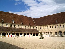
 Rathaus (Mairie) von Pontpoint | ||
Pontpoint [] ist eine französische Gemeinde mit 3251 Einwohnern (Stand: 1. Januar 2021) im Département Oise in der Region Hauts-de-France; sie gehört zum Arrondissement Senlis und zum Kanton Pont-Sainte-Maxence. Die Einwohner heißen Pontponniens.
Geographie
[Bearbeiten | Quelltext bearbeiten]Pontpoint liegt im Pariser Becken, 55 Kilometer nordöstlich von Paris, in der Landschaft Valois am Ufer des Flusses Oise. Umgeben wird Pontpoint von den Nachbargemeinden Houdancourt im Norden, Longueil-Sainte-Marie im Nordosten, Rhuis und Roberval im Osten, Villeneuve-sur-Verberie im Südosten, Villers-Saint-Frambourg-Ognon mit Villers-Saint-Frambourg im Süden sowie Pont-Sainte-Maxence im Westen.
Am nordöstlichen Rand der Gemeinde führt die Autoroute A1 entlang.
Bevölkerungsentwicklung
[Bearbeiten | Quelltext bearbeiten]| 1962 | 1968 | 1975 | 1982 | 1990 | 1999 | 2006 | 2011 | 2018 |
|---|---|---|---|---|---|---|---|---|
| 1403 | 1397 | 1763 | 2382 | 2724 | 2794 | 2865 | 3157 | 3250 |
| Quellen: Cassini und INSEE | ||||||||
Sehenswürdigkeiten
[Bearbeiten | Quelltext bearbeiten]- Abtei Saint-Jean-Baptiste du Moncel, 1309 von Philipp dem Schönen begründet, Monument historique seit 1920, Brunnen (seit 1933 Monument historique), Gutshof (seit 1988 Monument historique), Haus der Väter (Franziskanerherberge, seit 1920 Monument historique), Turm von Fécamp
- Kirche Saint-Gervais, romanischer Glockenturm aus dem 11. Jahrhundert, teilweise gotische Elemente aus dem 12. Jahrhundert, Monument historique seit 1902

- Kirche Saint-Pierre, weitgehend romanisch errichtet, nur noch als Ruine erhalten, Monument historique seit 2001
- Herrenhaus Saint-Symphorien, seit 1921 Monument historique
- Schloss Bois-Feuillette, 1903 im klassizistischen Stil errichtet
- Priorat Saint-Nicolas aus dem 17. Jahrhundert
- Alte Kapelle von Senneville-Rouffiac
- Waschhäuser
- Forêt d’Halatte, Waldgebiet mit der Erhebung des Mont Calipet (221 Meter)
Siehe auch: Liste der Monuments historiques in Pontpoint
Weblinks
[Bearbeiten | Quelltext bearbeiten]Text is available under the CC BY-SA 4.0 license; additional terms may apply.
Images, videos and audio are available under their respective licenses.


