Barbery (Oise)
aus Wikipedia, der freien Enzyklopädie
| Barbery | ||
|---|---|---|
| ||
| Staat | Frankreich | |
| Region | Hauts-de-France | |
| Département (Nr.) | Oise (60) | |
| Arrondissement | Senlis | |
| Kanton | Pont-Sainte-Maxence | |
| Gemeindeverband | Senlis Sud Oise | |
| Koordinaten | 49° 13′ N, 2° 40′ O | |
| Höhe | 68–102 m | |
| Fläche | 7,60 km² | |
| Einwohner | 547 (1. Januar 2021) | |
| Bevölkerungsdichte | 72 Einw./km² | |
| Postleitzahl | 60810 | |
| INSEE-Code | 60045 | |
| Website | http://barbery.oise.free.fr/ | |
 Rathaus (Mairie) von Barbery | ||

Barbery ist eine französische Gemeinde mit 547 Einwohnern (Stand: 1. Januar 2021) im Département Oise in der Region Hauts-de-France. Barbery gehört zum Arrondissement Senlis und zum Kanton Pont-Sainte-Maxence (bis 2015: Kanton Senlis). Die Einwohner werden Barberisiens genannt.
Geographie
[Bearbeiten | Quelltext bearbeiten]Barbery ist ein kleiner Vorort wenige Kilometer östlich von Senlis. Umgeben wird Barbery von den Nachbargemeinden Brasseuse im Norden, Rully im Norden und Nordosten, Montépilloy im Osten und Südosten, Borest im Süden, Mont-l’Évêque im Südwesten, Chamant im Westen sowie Villers-Saint-Frambourg-Ognon mit Ognon im Nordwesten.
Bevölkerungsentwicklung
[Bearbeiten | Quelltext bearbeiten]| 1962 | 1968 | 1975 | 1982 | 1990 | 1999 | 2006 | 2013 | 2021 |
|---|---|---|---|---|---|---|---|---|
| 554 | 531 | 480 | 452 | 483 | 518 | 501 | 558 | 547 |
| Quelle: Cassini und INSEE | ||||||||
Sehenswürdigkeiten
[Bearbeiten | Quelltext bearbeiten]- Kirche Saint-Rémy aus dem 12. Jahrhundert, seit 1978 Monument historique
- Ehemaliges Herrenhaus
-
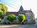 Kirche Saint-Rémy
 -
 Ehemaliges Herrenhaus
,_fa%C3%A7ade_sud_de_l%27%C3%A9glise_Saint-R%C3%A9mi.jpg)
,_boulangerie,_rue_du_G%C3%A9n%C3%A9ral_Patton.jpg)
Persönlichkeiten
[Bearbeiten | Quelltext bearbeiten]- Éloi-Charlemagne Taupin (1767–1814), Divisionsgeneral
Weblinks
[Bearbeiten | Quelltext bearbeiten]Commons: Barbery – Sammlung von Bildern, Videos und Audiodateien
Text is available under the CC BY-SA 4.0 license; additional terms may apply.
Images, videos and audio are available under their respective licenses.
Cover photo is available under {{::mainImage.info.license.name || 'Unknown'}} license.
Cover photo is available under {{::mainImage.info.license.name || 'Unknown'}} license.
Credit:
(see original file).
