Cookstown (District)
aus Wikipedia, der freien Enzyklopädie
| Cookstown District Ceantar na Coirre Críochaí | |
|---|---|
 | |
| Geografie | |
| Traditionelle Grafschaft | County Tyrone und County Londonderry |
| Fläche | 622 km² |
| Verwaltungssitz | Cookstown |
| ISO 3166-2 | GB-CKT |
| Demografie | |
| Bevölkerung | 37.411 (2012)[1] |
| Dichte | 60 Ew./km² |
| Konfessionen | Protestanten 34,0 % Katholiken 55,1 %[2] |
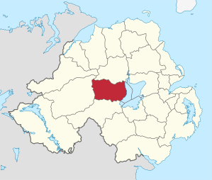
Cookstown (irisch An Chorr Chríochach) war einer der 26 nordirischen Districts, die von 1973 bis 2015 bestanden. Der District lag in den traditionellen Grafschaften Tyrone und Londonderry. Der Verwaltungssitz war die Stadt Cookstown. Weitere bedeutende Orte waren Pomeroy, Moneymore, Coagh und Stewartstown. Zum 1. April 2015 ging er im neuen District Mid Ulster auf.
Der District lag am Ostufer von Lough Neagh.
Cookstown Council
[Bearbeiten | Quelltext bearbeiten]Die Wahl zum Cookstown Council am 11. Mai 2011 hatte folgendes Ergebnis:[3]
| Partei | Ergebnis 2011 | Veränderung zu 2005 | |||
|---|---|---|---|---|---|
| Sitze | Stimmen | Sitze | Stimmen | ||
| Sinn Féin | 6 | 39,1 % | 1 | 5,6 % | |
| Social Democratic and Labour Party (SDLP) | 4 | 18,0 % | −1 | 0,7 % | |
| Democratic Unionist Party (DUP) | 3 | 18,1 % | 0 | −4,4 % | |
| Ulster Unionist Party (UUP) | 3 | 16,9 % | 0 | −2,6 % | |
| Traditional Unionist Voice | 0 | 7,4 % | 0 | 7,4 % | |
Siehe auch
[Bearbeiten | Quelltext bearbeiten]Einzelnachweise
[Bearbeiten | Quelltext bearbeiten]- ↑ Northern Ireland Population Estimates 2012 (XLS-Datei) ( des vom 10. Oktober 2013 im Internet Archive) Info: Der Archivlink wurde automatisch eingesetzt und noch nicht geprüft. Bitte prüfe Original- und Archivlink gemäß Anleitung und entferne dann diesen Hinweis.
- ↑ Northern Ireland Census 2011: Religion (administrative geographies)
- ↑ Wahlergebnis bei BBC News (Abgerufen am 26. Juli 2011)
Antrim | Ards | Armagh | Ballymena | Ballymoney | Banbridge | Belfast | Carrickfergus | Castlereagh | Coleraine | Cookstown | Craigavon | Derry | Down | Dungannon and South Tyrone | Fermanagh | Larne | Limavady | Lisburn | Magherafelt | Moyle | Newry and Mourne | Newtownabbey | North Down | Omagh | Strabane
Koordinaten: 54° 38′ 35″ N, 6° 44′ 42″ W
Text is available under the CC BY-SA 4.0 license; additional terms may apply.
Images, videos and audio are available under their respective licenses.
