Ards
aus Wikipedia, der freien Enzyklopädie
| Ards Borough Buirg na hArda | |
|---|---|
 | |
| Geografie | |
| Traditionelle Grafschaft | County Down |
| Fläche | 376 km² |
| Verwaltungssitz | Newtownards |
| ISO 3166-2 | GB-ARD |
| Demografie | |
| Bevölkerung | 78.550 (2012)[1] |
| Dichte | 209 Ew./km² |
| Konfessionen | Protestanten 65,5 % Katholiken 10,9 %[2] |
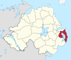
Ards (irisch: An Aird) war einer der 26 nordirischen Districts, die von 1973 bis 2015 bestanden. Der District, dessen Gebiet in der traditionellen Grafschaft Down lag, besaß den Status eines Borough. Er lag an der nordirischen Ostküste und umschloss die Bucht Strangford Lough. Benannt wurde der District nach der Ards-Halbinsel, die einen Teil des Districtgebietes bildete. Der Verwaltungssitz war in Newtownards. Weitere bedeutende Orte im Borough waren Portaferry, Comber und Donaghadee. Zum 1. April 2015 ging er im neuen District Ards and North Down auf.
Ards Borough Council
[Bearbeiten | Quelltext bearbeiten]Die Wahl zum Ards Borough Council am 11. Mai 2011 hatte folgendes Ergebnis:[3]
| Partei | Ergebnis 2011 | Veränderung zu 2005 | |||
|---|---|---|---|---|---|
| Sitze | Stimmen | Sitze | Stimmen | ||
| Democratic Unionist Party (DUP) | 11 | 47,4 % | −1 | −5,0 % | |
| Ulster Unionist Party (UUP) | 6 | 17,5 % | −1 | −7,0 % | |
| Alliance Party | 4 | 18,2 % | +1 | 4,2 % | |
| Social Democratic and Labour Party (SDLP) | 1 | 6,8 % | 0 | 3,4 % | |
| Traditional Unionist Voice | 0 | 3,4 % | 0 | 3,4 % | |
| Green Party | 0 | 0,8 % | 0 | 0,1 % | |
| Sonstige | 0 | 0,5 % | 0 | 0,5 % | |
| Unabhängige | 1 | 5,4 % | 1 | 1,6 % | |
Die Megalithanlage von Millin Bay liegt auf der Halbinsel.
Siehe auch
[Bearbeiten | Quelltext bearbeiten]Einzelnachweise
[Bearbeiten | Quelltext bearbeiten]- ↑ Northern Ireland Population Estimates 2012 (XLS-Datei) ( des vom 10. Oktober 2013 im Internet Archive) Info: Der Archivlink wurde automatisch eingesetzt und noch nicht geprüft. Bitte prüfe Original- und Archivlink gemäß Anleitung und entferne dann diesen Hinweis.
- ↑ Northern Ireland Census 2011: Religion (administrative geographies) (Seite nicht mehr abrufbar, festgestellt im Juni 2023. Suche in Webarchiven) Info: Der Link wurde automatisch als defekt markiert. Bitte prüfe den Link gemäß Anleitung und entferne dann diesen Hinweis.
- ↑ Wahlergebnis bei BBC News (Abgerufen am 26. Juli 2011)
Antrim | Ards | Armagh | Ballymena | Ballymoney | Banbridge | Belfast | Carrickfergus | Castlereagh | Coleraine | Cookstown | Craigavon | Derry | Down | Dungannon and South Tyrone | Fermanagh | Larne | Limavady | Lisburn | Magherafelt | Moyle | Newry and Mourne | Newtownabbey | North Down | Omagh | Strabane
Koordinaten: 54° 29′ 0″ N, 5° 35′ 0″ W
Text is available under the CC BY-SA 4.0 license; additional terms may apply.
Images, videos and audio are available under their respective licenses.
