For faster navigation, this Iframe is preloading the Wikiwand page for Datoteka:Ecuador relief location map.svg.

Datoteka:Ecuador relief location map.svg
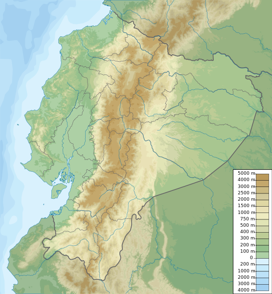
Izvorna datoteka(SVG datoteka, nominalno 851 × 917 piksela, veličina datoteke: 3,76 MB)

Sažetak

Opis Ecuador physical map, parameters equal to File:Ecuador location map.svg
Datum
Izvor Vlastito djelo
Autor Urutseg

Licenciranje

Ja, vlasnik autorskog prava ovog djela, ovdje ga objavljujem pod sljedećom licencom:
Creative Commons CC-Zero Ova datoteka je dostupna pod licencom Creative Commons CC0 1.0 Univerzalnom Posvetom Javne Domene.
Osoba koja je učestvovala u radu na ovom dokumentu posvetila je rad javnoj domeni odricanjem od svih svojih prava na taj rad širom svijeta po zakonu o autorskim pravima i svim povezanim zakonskim pravima koja bi imao/imala, u mjeri dopuštenoj zakonom. Možete kopirati, mijenjati, distribuirati i prilagođavati rad, čak i u komercijalne svrhe, bez traženja dopuštenja.

Captions

Add a one-line explanation of what this file represents

Items portrayed in this file

prikazuje

Historija datoteke

Kliknite na datum/vrijeme da vidite verziju datoteke iz tog vremena.

Datum/vrijemeSmanjeni pregledDimenzijeKorisnikKomentar
trenutno21:49, 15 oktobar 2012Smanjeni pregled verzije na dan 21:49, 15 oktobar 2012851 × 917 (3,76 MB)Milenioscurocorrections of coastal line and boundaries (according to Ecuador location map.svg)
17:16, 26 august 2012Smanjeni pregled verzije na dan 17:16, 26 august 20121.536 × 1.654 (2,49 MB)Joffrenomuereson 24 Provincias no 22
10:04, 15 juni 2012Smanjeni pregled verzije na dan 10:04, 15 juni 2012851 × 917 (2,13 MB)TUBSrv: please follow map conventions, cf your disk
20:53, 13 juni 2012Smanjeni pregled verzije na dan 20:53, 13 juni 2012851 × 917 (2,35 MB)Joffrenomuere24 provincias
21:00, 14 mart 2011Smanjeni pregled verzije na dan 21:00, 14 mart 2011851 × 917 (2,13 MB)Urutseg

Upotreba datoteke

Globalna upotreba datoteke

Sljedeći wikiji koriste ovu datoteku:

Pogledajte globalne upotrebe ove datoteke.

Metapodaci

{{bottomLinkPreText}} {{bottomLinkText}}
Datoteka:Ecuador relief location map.svg
Listen to this article

This browser is not supported by Wikiwand :(
Wikiwand requires a browser with modern capabilities in order to provide you with the best reading experience.
Please download and use one of the following browsers:

This article was just edited, click to reload
This article has been deleted on Wikipedia (Why?)

Back to homepage

Please click Add in the dialog above
Please click Allow in the top-left corner,
then click Install Now in the dialog
Please click Open in the download dialog,
then click Install
Please click the "Downloads" icon in the Safari toolbar, open the first download in the list,
then click Install
{{::$root.activation.text}}

Install Wikiwand

Install on Chrome Install on Firefox
Don't forget to rate us

Tell your friends about Wikiwand!

Gmail Facebook Twitter Link

Enjoying Wikiwand?

Tell your friends and spread the love:
Share on Gmail Share on Facebook Share on Twitter Share on Buffer

Our magic isn't perfect

You can help our automatic cover photo selection by reporting an unsuitable photo.

This photo is visually disturbing This photo is not a good choice

Thank you for helping!


Your input will affect cover photo selection, along with input from other users.

X

Get ready for Wikiwand 2.0 🎉! the new version arrives on September 1st! Don't want to wait?