Franklin County, Arkansas
| Vawoitung | |
|---|---|
| US-Bundesstoot: | Arkansas |
| Sitz vo da Vawoitung: | Ozark (northern district), Charleston, (southern district) |
| Adress vom Vawoitungssitz: |
County Courthouse 211 W. Commerical Street Ozark, AR 72949-3233 |
| Grindung: | 1837 |
| Buidt aus: | Crawford County |
| Vuawoi: | 001 479 |
| Demographie | |
| Eihwohna: | 18.125 (2010) |
| Dichtn: | 11,5 Eihwohna/km² |
| Eadkund | |
| Flächn gesamt: | 1.605 km² |
| Wossaflächn: | 26 km² |
| Koartn | |
 | |
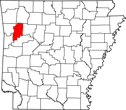
Franklin County[1] is a Beziak im Bundesstoot Arkansas in da USA. Da Beziak hod 18.125 Eihwohna. Da Sitz vo da Vawoitung is Ozark (northern district) und Charleston, (southern district).
Da Beziak hod a Fläche vo 1.605 Quadratkilometa, dovo san 26 Quadratkilometa Wossafläche.
Gmoana
[Werkeln | Am Gwëntext werkeln]Citys
|
|
Town
- Denning
- Alix
- Cecil
- weitare Oate
- Barnes
- Beach Grove
- Cass
- Cravens
- Etna
- Fern
- Greenwood
- Jethro
- Lone Elm
- Meg
- Mineral Springs
- Mountain Crest
- Mountain Grove
- Mountain Top
- Paradise
- Peanut
- Peter Pender
- Piney
- Pittston Junction
- Pleasant View
- Poping
- Redding
- South Ozark
- Sutherland Crossroads
- Toney
- Vesta
- Webb City
- West Cobb
Townships
- Alix Township
- Barham Township
- Black Oak Township
- Boston Township
- Cobb Township
- Cravens Township
- Donald Township
- Grover Township
- Hogan Township
- Hurricane Township
- Ivy Township
- Limestone Township
- McIlroy Township
- Middle Township
- Mill Creek Township
- Miller Township
- Morgan Township
- Mountain Township
- Mulberry Township
- Prairie Township
- Shores Township
- Six Mile Township
- Walker Township
- Wallace Township
- Watalula Township
- Weaver Township
- White Oak Township
- White Rock Township
- Wittich Township
Beleg
[Werkeln | Am Gwëntext werkeln]- ↑ GNIS-ID: 66853. Abgerufen am 22. Februar 2011 (englisch).
|
Countys in Arkansas
|
Koordinaten: 35° 31′ N, 93° 53′ W
Text is available under the CC BY-SA 4.0 license; additional terms may apply.
Images, videos and audio are available under their respective licenses.
