For faster navigation, this Iframe is preloading the Wikiwand page for
Mississippi County, Arkansas .
Mississippi County Courthouse in Osceola, seit 1978 im NRHP glistet[ 1]
Vawoitung
US-Bundesstoot :
Arkansas
Sitz vo da Vawoitung:
Blytheville, Osceola
Adress vom
County Courthouse
Grindung:
1833
Buidt aus:
Crittenden County
Vuawoi:
001 870
Demographie
Eihwohna:
46.480 (2010)
Dichtn:
20 Eihwohna/km²
Eadkund
Flächn gesamt:
2.382 km²
Wossaflächn:
56 km²
Koartn
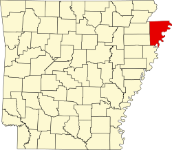
Koartn vo Mississippi County innahoib vo Arkansas
Hoamseitn : www.mcagov.com
Mississippi County [ 2] Arkansas in da USA . Da Beziak hod 46480 Eihwohna. Da Sitz vo da Vawoitung is Blytheville und Osceola.
Da Beziak hod a Fläche vo 2.382 Quadratkilometa, dovo san 56 Quadratkilometa Wossafläche.
Citys
Blytheville
Gosnell
Joiner
Towns
Bassett
Birdsong
Burdette
Dell
Dyess
Etowah
Marie
Victoria
Unincorporated Communities
Arkmo
Armorel
Athelstan
Bardstown
Barfield
Big Lake
Bondsville
Boynton
Buckeye
Burton
Butler
Calumet
Carmi
Carrol Corner
Carson Lake
Chelford
Chickasawba
Creamery Package
Clear Lake
Clearwater
Cole Ridge
Cottonwood Corner
Dearman
Delpro
Denwood
Dimple
Dogwood
Driver
Eastview
Evadale
Floodway
Frenchmans Bayou
Garson
Golden Lake
Grider
Half Moon
Happy Corners
Hickman
Hightower
Hilton
Huffman
Lemsford
Lennie
Little Green Store
Little River
Lowden
Mandalay
McClendons Corner
McFerrin
Midway
Milligan Ridge
Moran
Muir
Nodena
Norden
Number Nine
O'Donnell Bend
Pawheen
Pecan Point
Pettyville
Red Line
Rington
Rokey
Rosa
Roseland
Rotan
Roy
Saint Thomas
Sans Souci
Shady Grove
Shawnee
Shippen
Spur Four
Stark City
Three Way
Tomato
Tukertown
Turner
Vail
Walters
Wardell
Westover
West Ridge
Whisp
Whistleville
Whitton
Wilson Junction
Woodland Corner
Yarbro
↑ Auszug aus dem National Register of Historic Places - Nr. 78000612 Obgruafa am 22. Aprü 2011↑ GNIS-ID: 69899. Abgerufen am 22. Februar 2011 (englisch). 35.776666666667 -90.054444444444 Koordinaten: 35° 47′ N , 90° 3′ W
{{bottomLinkPreText}}
{{bottomLinkText}}
This page is based on a Wikipedia article written by
contributors (read /edit ).CC BY-SA 4.0 license; additional terms may apply.
Mississippi County, Arkansas
{{current.index+1}} of {{items.length}}
Thanks for reporting this video!
This browser is not supported by Wikiwand :(
An extension you use may be preventing Wikiwand articles from loading properly.HTTPS Everywhere or you're unable to access any article on Wikiwand, please consider switching to HTTPS (https ://www.wikiwand.com).
An extension you use may be preventing Wikiwand articles from loading properly.Ad-Blocker , it might have mistakenly blocked our content.
You will need to temporarily disable your Ad-blocker to view this page.
✕
This article was just edited, click to reload
Please click Add in the dialog above
Please click Allow in the top-left corner, Install Now in the dialog
Please click Open in the download dialog, Install
Please click the "Downloads" icon in the Safari toolbar, open the first download in the list, Install
{{::$root.activation.text}}
Follow Us
Don't forget to rate us
Oh no, there's been an error
Please help us solve this error by emailing us at
support@wikiwand.com
Let us know what you've done that caused this error, what browser you're using, and whether you have any special extensions/add-ons installed.
Thank you!


