Rhode Island
| Rhode Island Rhode Island | |||||
| Estau d'os Estaus Unius | |||||
| |||||
| Lema: Hope | |||||
| Embotada: The Ocean State, Little Rhody | |||||
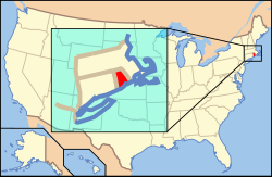
 Mapa de situación en Estaus Unius | |||||
| Entidat • País • Capital • Mayor ciudat |
Estau Providence Providence | ||||
| Idioma oficial | denguna (de facto, anglés) | ||||
| Gubernador Senadors |
Donald Carcieri (R) Jack Reed (D) Sheldon Whitehouse (D) | ||||
| Superficie • Total • Tierra • Augua |
3.144 km² (50ª) 2.706 km² 1.295 km² (32,4%) | ||||
| Población • Total • Densidat |
1.057.832[1] (43ª) 390,78 hab./km² (2ª) | ||||
| Dentrada • Calendata • Orden |
29 de mayo de 1790 13º | ||||
| Cheografía • Horario • Latitut • Lonchitut • Amplaria • Longaria |
Este: UTC-5 41° 09' N a 42° 01' N 71° 07' W a 71° 53' W 60 km 77 km | ||||
| Altaria • Maxima • Meyana • Minima |
247 m (Jerimoth Hill[2]) 60 m 0 m (Oceano Atlantico[2]) | ||||
| Codigos • USPS • ISO 3166-2 |
RI US-RI | ||||
| www.ri.gov | |||||
Rhode Island ye uno d'os 50 estaus d'Estaus Unius, situau a o nord-este d'o país. A suya capital ye a ciudat de Providence. A suya población ye de 1.057.832 habitants (estimación de 2007), en una superficie de 3.144 km² con una densidat de población de 336,46 hab/km².
Cheografía
[editar | modificar o codigo]O estau de Rhode Island muga a o norte y a l'este con Massachusetts; a l'ueste con Connecticut; y a o sud con Nueva York y l'Oceano Atlantico.
Historia
[editar | modificar o codigo]Rhode Island estió o 13º estau en dentrar en os Estaus Unius, o 29 de mayo de 1790.
Galería d'imachens
[editar | modificar o codigo]Vinclos externos
[editar | modificar o codigo] Se veigan as imáchens de Commons sobre Rhode Island.
- (en) Pachina web oficial de Rhode Island.
Referencias
[editar | modificar o codigo]
| Organización territorial d'os Estaus Unius d'America | ||||||
|---|---|---|---|---|---|---|
|
Text is available under the CC BY-SA 4.0 license; additional terms may apply.
Images, videos and audio are available under their respective licenses.


