For faster navigation, this Iframe is preloading the Wikiwand page for Indiana.

Indiana

Iste articlo ye en proceso de cambio enta la ortografía oficial de Biquipedia (la Ortografía de l'aragonés de l'Academia Aragonesa d'a Luenga). Puez aduyar a completar este proceso revisando l'articlo, fendo-ie los cambios ortograficos necesarios y sacando dimpués ista plantilla.
Estau d'Indiana
State of Indiana
Estau d'os Estaus Unius
Escudo
Bandera Escudo
Lema: The Crossroads of America
Embotada: The Hoosier State

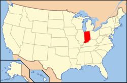
Mapa de situación en Estaus Unius
Entidat
 • País
 • Capital
 • Mayor ciudat
Estau
Estaus Unius
Indianapolis (785.597)
Idioma oficial Anglés
Gubernador
Senadors
Mitch Daniels (R)
Richard Lugar (R)
Evan Bayh (D)
Superficie
 • Total
 • Tierra
 • Augua

94.321 km² (38ª)
92.897 km²
1.424 km² (1,5%)
Población
 • Total
 • Densidat

6.080.485 (15ª)
65,46 hab./km² (16ª)
Dentrada
 • Calendata
 • Orden

11 d'aviento de 1816
19º
Cheografía
 • Horario

 • Latitut
 • Lonchitut
 • Amplaria
 • Longaria

Este: UTC-5/UTC-4
Central: UTC-6/UTC-5
37°47'N a 41°46'N
84°49'U a 88°4'U
225 km
435 km
Altaria
 • Maxima
 • Meyana
 • Minima

383 m (Hoosier Hill)
210 m
98 m (Río Ohio)
Codigos
 • USPS
 • ISO 3166-2

IN
US-IN
www.in.gov

Indiana (prenunciau /ˌɪndiˈænə/) ye uno d'os 50 estaus d'Estaus Unius, situau en a rechión d'o Midwest. A suya capital ye Indianapolis, que ye tamién a ciudat con un numero d'habitants mas gran.

A suya población ye de 6.080.485 habitants (2000), en una superficie de 94.321 km², con una densidat de población de 65,46 hab/km².

Vinclos externos

[editar | modificar o codigo]


Organización territorial d'os Estaus Unius d'America Bandera d'os Estaus Unius
Estaus Alabama | Alaska | Arizona | Arkansas | California | Carolina d'o Norte | Carolina d'o Sud | Colorado | Connecticut | Cheorchia | Dakota d'o Norte | Dakota d'o Sud | Delaware | Florida | Hawaii | Idaho | Illinois | Indiana | Iowa | Kansas | Kentucky | Loisiana | Maine | Massachusetts | Maryland | Michigan | Minnesota | Mississippi | Missouri | Montana | Nebraska | Nevada | Nuevo Mexico | Nueva Hampshire | Nueva Jersey | Nueva York | Ohio | Oklahoma | Oregón | Pennsilvania | Rhode Island | Tennessee | Texas | Utah | Virchinia | Virchinia Occidental | Vermont | Washington | Wisconsin | Wyoming
Districto federal Districto de Columbia
Arias insulars Arrecife Kingman | Atol Palmyra | Atol Johnston | Guam | Isla Baker | Isla Howland | Isla Jarvis | Islas Marianas d'o Norte | Atol Midway | Isla Navassa | Islas Vírchens d'os Estaus Unius | Isla Wake | Puerto Rico | Samoa Americana
{{bottomLinkPreText}} {{bottomLinkText}}
Indiana
Listen to this article

This browser is not supported by Wikiwand :(
Wikiwand requires a browser with modern capabilities in order to provide you with the best reading experience.
Please download and use one of the following browsers:

This article was just edited, click to reload
This article has been deleted on Wikipedia (Why?)

Back to homepage

Please click Add in the dialog above
Please click Allow in the top-left corner,
then click Install Now in the dialog
Please click Open in the download dialog,
then click Install
Please click the "Downloads" icon in the Safari toolbar, open the first download in the list,
then click Install
{{::$root.activation.text}}

Install Wikiwand

Install on Chrome Install on Firefox
Don't forget to rate us

Tell your friends about Wikiwand!

Gmail Facebook Twitter Link

Enjoying Wikiwand?

Tell your friends and spread the love:
Share on Gmail Share on Facebook Share on Twitter Share on Buffer

Our magic isn't perfect

You can help our automatic cover photo selection by reporting an unsuitable photo.

This photo is visually disturbing This photo is not a good choice

Thank you for helping!


Your input will affect cover photo selection, along with input from other users.

X

Get ready for Wikiwand 2.0 🎉! the new version arrives on September 1st! Don't want to wait?