Rããnkl
| Rankweil | ||
|---|---|---|
 |
| |
| Basisdate | ||
| Staat: | Östriich | |
| Bundesland: | Vorarlberg | |
| Politische Bezirk: | Feldkirch | |
| Kfz-Kennzeiche: | FK | |
| Fläche: | 21,85 km² | |
| Koordinate: | 47° 16′ N, 9° 39′ O | |
| Höchi: | 468 m ü. A. | |
| Iiwohner: | 12.150 (1. Jän. 2023) | |
| Bevölkerigsdichti: | 556,06 Iiw. pro km² | |
| Poschtleitzahl: | 6830 | |
| Vorwahl: | 05522 | |
| Gmoandskennziffer: | 8 04 14 | |
| NUTS-Region | AT342 | |
| Adress vo dr Gmoandsverwaltig: |
Am Marktplatz 1 6830 Rankweil | |
| Website: | ||
| Politik | ||
| Burgermoaschter: | Katharina Wöß-Krall (ÖVP) | |
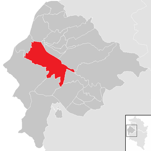
| Lag vo dr Marktgmuand
Name = Rankweil Rankweil im Bezirk Feldkirch | ||
 | ||
 Rããnkl, Liabfrouebearg | ||
| (Quelle: Gmoanddate bi Statistik Austria) | ||


| Dialäkt: Vorarlbärgisch |
Rããnkl (amtlich Rankweil) ischt a Marktgmuand im Bezirk Fealkirch (Region Rhiital) z Vorarlberg, Öschtriich.
Geografi
[ändere | Quälltäxt bearbeite]Rããnkl lit im obere Rhiital uf 468 Meter Höhe. Vom Gmuandsgbiet siand im Johr 1996 45,7 % Landwirtschaftsfläch, 30,4 % Wald, 15,0 % Sidlungsfläche und 8,8 % sunschtige Fläche gsi.[1] D Nochburgmuanda vo Rããnkl siand Koblach, Röthis, Sulz, Zwischenwasser, Laterns, Übersaxen, Satteins, Göfis, Feldkirch und Meiningen.
Gschicht
[ändere | Quälltäxt bearbeite]Rããnkl ischt zum erschte Mol gnennt worra im Johr 842.
Verwaltig
[ändere | Quälltäxt bearbeite]D Bürgermöaschtre vo Rããnkl ischt d Katharina Wöß-Krall.
Iiwohner
[ändere | Quälltäxt bearbeite]Quella: Statistik Austria: Bevölkerung seit 1869 für Gemeinden. STATcube
| Johr | 1869 | 1880 | 1890 | 1900 | 1910 | 1923 | 1934 | 1939 |
| Iiwohner | 2.410 | 2.686 | 2.976 | 3.304 | 3.923 | 3.724 | 4.229 | 4.447 |
| Johr | 1951 | 1961 | 1971 | 1981 | 1991 | 2001 | 2011 | 2021 |
| Iiwohner | 5.244 | 6.451 | 8.654 | 9.926 | 10.509 | 11.171 | 11.575 | 11.855 |
Dialekt
[ändere | Quälltäxt bearbeite]Dr Dialekt vo Rããnkl khört zum Bodeseealemannisch.
Weblink
[ändere | Quälltäxt bearbeite]Fuaßnota
[ändere | Quälltäxt bearbeite]- ↑ Amt der Vorarlberger Landesregierung (Hrsg): Strukturdaten Vorarlberg. Bregenz 1996
Städt und Gmoanda im Bezirk Fealdkirch
Alta |
Düns |
Dünserberg |
Fealdkirch |
Frastaz |
Fraxara |
Göfis |
Getzis |
Kluus |
Kobla |
Laterns |
Mäder |
Moanige |
Rankl |
Röns |
Röthis |
Sattaas |
Schlins |
Schnifis |
Sulz |
Übersaxe |
Viktorsbearg |
Wiiler |
Zwüschawasser
Text is available under the CC BY-SA 4.0 license; additional terms may apply.
Images, videos and audio are available under their respective licenses.
Cover photo is available under {{::mainImage.info.license.name || 'Unknown'}} license.
Cover photo is available under {{::mainImage.info.license.name || 'Unknown'}} license.
Credit:
(see original file).
