Levuburivier
| Levuburivier | |
|---|---|
 | |
| Oorsprong | Soutpansberg |
| Monding | by Pafuri, Makuleke, grens tussen Suid-Afrika en Mosambiek Limpoporivier |
| Stroomgebied | Suid-Afrika |
| Lengte | 200 km (124 myl) |
| Mondinghoogte | 203 m (666 vt) |
| Stroomgebiedopp. | 4 826 km² (1 863 myl²) |
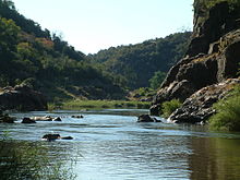
Die Levuburivier of Levuvhu[1] (Tsonga: Rivubye; Venda: Luvuvhu)[2] is geleë in die noorde van die Limpopoprovinsie van Suid-Afrika. Sommige van sy sytakke, soos die Mutshindudirivier en die Mutalerivier ontspring in die Soutpansberge. Die sytakke in die Krugerwildtuin is die Matukwane, Madziringwe, Mashikiri en voorgenoemde Mutale.[3]


Die Luvuvhurivier vloei vir ongeveer 200 km deur 'n verskeidenheid van landskappe voordat dit aansluit by die Limpoprivier in die koorsboombos naby Pafuri in die Krugerwildtuin.[4]
'n Zambezihaai (Carcharhinus leucas) is by die samevloeiing van die Limpopo- en Luvuburiviere gevang in Julie 1950. Zambezihaaie verdra vars water en kan ver opswem in groot riviere soos die Limpopo.[5]
Opvanggebied
[wysig | wysig bron]Die opvanggebied van die Levubu word op 4 826 km2 bereken.[6]
Damme
[wysig | wysig bron]- Albasinidam
- Mambedidam
- Tshakhumadam
- Damanidam
- Nandonidam, voorheen bekend as die Mutotidam, in die middelste gedeelte van die Luvuburivier oos van die sameloop met die Dzindiriviersytak en oos van die dorp Thohoyandou[7]
- Vondodam in die Mutshindudirivier, 'n sytak
- Phiphididam in die Mutshindudi
Verwysings
[wysig | wysig bron]- ↑ Olifants River now called Lepelle
- ↑ Jenkins, Elwyn (2007), Falling into place: the story of modern South African place names, David Philip Publishers, p. 75
- ↑ Petersen, Robin; Riddell, Eddie; Govender, Danny; Sithole, Hendrik; Venter, Jacques; Mohlala, Thabo (2015). "State of the rivers – Kruger National Park" (PDF). sanparks.org. Savanna Science Networking Meeting 2015 – Skukuza, KNP. Besoek op 25 Februarie 2022.
- ↑ Latava and Luvuvhu River River Systems 2001 Geargiveer 2 April 2015 op Wayback Machine, State of Rivers Report, WRC report no: TT 165/01, Water Research Commission, Pretoria, ISBN No: 1 86845 825 3
- ↑ Pienaar, U. de V., The Freshwater Fishes of the Kruger National Park, Koedoe Vol 11, No 1 (1968)
- ↑ http://www.fao.org/3/y5744e/y5744e07.htm
- ↑ "Nandoni Dam - Description". Geargiveer vanaf die oorspronklike op 20 Mei 2020. Besoek op 14 April 2018.
Eksterne skakels
[wysig | wysig bron] Wikimedia Commons het meer media in die kategorie Levuburivier.
Text is available under the CC BY-SA 4.0 license; additional terms may apply.
Images, videos and audio are available under their respective licenses.
