File:Trebizond1300.png
此为最大尺寸。
Trebizond1300.png (552 × 392像素,文件大小:67 KB,MIME类型:image/png)
摘要
| 描述 |
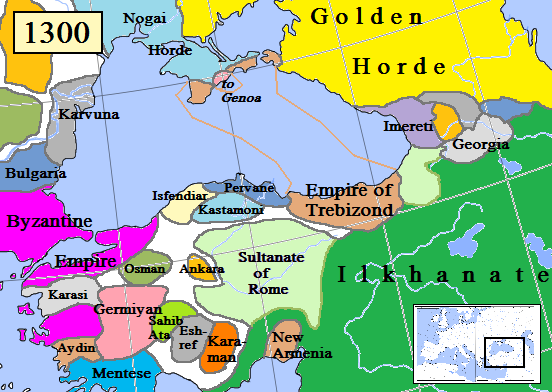
English: Map of the Trebizond Empire in Anatolia, AD 1300.
(Partially based on Euratlas map of Europe, 1300.) |
| 日期 | |
| 来源 | 自己的作品 |
| 作者 | Gabagool |

|
此historical map图片可使用矢量图形重新创建为SVG文件。这具有很多好处;更多信息请参见共享资源:待清理媒体。如果存在此图片的SVG格式,请将其上传,然后将此模板替换为
((vector version available|新图片名称))。
建议您将SVG命名为“Trebizond1300.svg”,这样在使用Vector version available(或Vva)模板时就不需要填写新图片名称参数。 |
许可协议
我,本作品著作权人,特此采用以下许可协议发表本作品:
本文件采用知识共享署名 3.0 未本地化版本许可协议授权。
- 您可以自由地:
- 共享 – 复制、发行并传播本作品
- 修改 – 改编作品
- 惟须遵守下列条件:
- 署名 – 您必须对作品进行署名,提供授权条款的链接,并说明是否对原始内容进行了更改。您可以用任何合理的方式来署名,但不得以任何方式表明许可人认可您或您的使用。
文件历史
点击某个日期/时间查看对应时刻的文件。
| 日期/时间 | 缩略图 | 大小 | 用户 | 备注 | |
|---|---|---|---|---|---|
| 当前 | 2023年8月12日 (六) 15:21 | | 552 × 392(67 KB) | Gyalu22 | Reverted to version as of 16:24, 16 November 2022 (UTC) Wallachia was not part of the Second Bulgarian Empire, see https://www.google.com/search?q=europe+map+1300 |
| 2023年5月12日 (五) 15:09 |  | 564 × 404(143 KB) | Moodylo333 | Correct borders & states year 1300 | |
| 2022年11月16日 (三) 16:24 |  | 552 × 392(67 KB) | Gyalu22 | Reverted to version as of 00:49, 13 December 2012 (UTC) | |
| 2019年8月15日 (四) 17:46 |  | 552 × 392(94 KB) | Georgiano | Reverted to version as of 17:44, 15 August 2019 (UTC) correct source: File:Map–Principality of Samtskhe till c.1325–ka.svg | |
| 2019年8月15日 (四) 17:45 |  | 552 × 392(89 KB) | Georgiano | Reverted to version as of 23:21, 2 April 2016 (UTC) | |
| 2019年8月15日 (四) 17:44 |  | 552 × 392(94 KB) | Georgiano | added Principality of Samtskhe (vassal of Ilkhanate between 1266–1334) source: File:Caucasus 1311 AD map de.png | |
| 2016年4月2日 (六) 23:21 |  | 552 × 392(89 KB) | Julieta39 | Cosmetic work, add Amastris, Montecastro, Caffa & Cembalo (to Genoa) and some details according with Claude Mutafian & Eric Van Lauwe’s « Atlas Historique de l’Armenie », Paris, ed. Autrement 2001, ISBN 2-7467-0100-6 | |
| 2016年3月14日 (一) 20:06 |  | 552 × 392(75 KB) | Georgiano | fixed borders of Georgian kingdoms | |
| 2015年7月17日 (五) 10:25 |  | 552 × 392(89 KB) | Spiridon Ion Cepleanu | Little rectifications. according with H.E.Stier's (dir.) « Westermann Grosser Atlas zur Weltgeschichte », 1985, ISBN 3-14-100919-8 for the year 1300 | |
| 2012年12月13日 (四) 00:49 |  | 552 × 392(67 KB) | Geagea | Reverted to version as of 19:54, 30 March 2009 |
文件用途
以下2个页面使用本文件:
全域文件用途
以下其他wiki使用此文件:
- ar.wikipedia.org上的用途
- azb.wikipedia.org上的用途
- az.wikipedia.org上的用途
- be.wikipedia.org上的用途
- bg.wikipedia.org上的用途
- cs.wikipedia.org上的用途
- diq.wikipedia.org上的用途
- dsb.wikipedia.org上的用途
- el.wikipedia.org上的用途
- en.wikipedia.org上的用途
- es.wikipedia.org上的用途
- et.wikipedia.org上的用途
- eu.wikipedia.org上的用途
- fa.wikipedia.org上的用途
- fiu-vro.wikipedia.org上的用途
- fr.wikipedia.org上的用途
- gl.wikipedia.org上的用途
- hr.wikipedia.org上的用途
- hu.wikipedia.org上的用途
- hy.wikipedia.org上的用途
- id.wikipedia.org上的用途
- it.wikipedia.org上的用途
- ka.wikipedia.org上的用途
- ku.wikipedia.org上的用途
- lt.wikipedia.org上的用途
- mk.wikipedia.org上的用途
- ms.wikipedia.org上的用途
- mzn.wikipedia.org上的用途
- nl.wikipedia.org上的用途
查看此文件的更多全域用途。
元数据
Text is available under the CC BY-SA 4.0 license; additional terms may apply.
Images, videos and audio are available under their respective licenses.
Cover photo is available under {{::mainImage.info.license.name || 'Unknown'}} license.
Cover photo is available under {{::mainImage.info.license.name || 'Unknown'}} license.
Credit:
(see original file).
