File:South Africa racial map, 1979.gif
本预览的尺寸:767 × 600像素。 其他分辨率:307 × 240像素 | 614 × 480像素 | 940 × 735像素。
原始文件 (940 × 735像素,文件大小:249 KB,MIME类型:image/gif)
摘要

|
此ethnographic map图片可使用矢量图形重新创建为SVG文件。这具有很多好处;更多信息请参见共享资源:待清理媒体。如果存在此图片的SVG格式,请将其上传,然后将此模板替换为
((vector version available|新图片名称))。
建议您将SVG命名为“South Africa racial map, 1979.svg”,这样在使用Vector version available(或Vva)模板时就不需要填写新图片名称参数。 |
| 描述 |
Afrikaans: Rassedemografie van Suid-Afrika volgens 1970-sensusdata
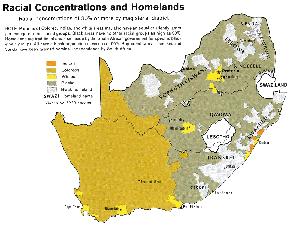
English: Map showing the territorial four main races/ethnicities/colors of South Africa in 1979: Whites, Coloureds, Blacks and Indians. The gray areas indicate the Apartheid-era Bantustans, which are almost exclusively black.
This map is a photoshopped version of the CIA-made original map at Perry Castañeda map collection at the University of Texas website. |
| 日期 | |
| 来源 |
本檔案是由Magnus Manske使用CommonsHelper,從en.wikipedia轉移到維基共享資源。 (Original text : * Site: Perry-Castañeda Library Map Collection: South Africa Maps |
| 作者 | U.S. Central Intelligence Agency |
| 授权 (二次使用本文件) |
Public domain |
| 其他版本 |
 |
许可协议
| 本图像是中央情报局雇员的职务作品。作为美国联邦政府的作品,本图像或媒体属于公有领域。
|

|
原始上传日志
原始描述頁面位於這裡。下列使用者名稱均來自en.wikipedia。
- 2008-08-23 06:02 MaGioZal 940×735× (254595 bytes) Map showing the territorial four main races/ethnicities/colors of South Africa in 1979: [[South African Whites|Whites]], [[Colored (South Africa)|Coloreds]], [[South African Blacks|Blacks]] and [[South African Indians|Indians]]. The gray areas indicate th
文件历史
点击某个日期/时间查看对应时刻的文件。
| 日期/时间 | 缩略图 | 大小 | 用户 | 备注 | |
|---|---|---|---|---|---|
| 当前 | 2011年2月19日 (六) 20:50 | | 940 × 735(249 KB) | File Upload Bot (Magnus Manske) | ((BotMoveToCommons|en.wikipedia|year=((subst:CURRENTYEAR))|month=((subst:CURRENTMONTHNAME))|day=((subst:CURRENTDAY)))) ((Information |Description=((en|Map showing the territorial four main races/ethnicities/colors of South Africa in 1979: [[:en:Whites in |
文件用途
以下4个页面使用本文件:
全域文件用途
以下其他wiki使用此文件:
- af.wikipedia.org上的用途
- ast.wikipedia.org上的用途
- ca.wikipedia.org上的用途
- cs.wikipedia.org上的用途
- en.wikipedia.org上的用途
- es.wikipedia.org上的用途
- fa.wikipedia.org上的用途
- ha.wikipedia.org上的用途
- he.wikipedia.org上的用途
- krc.wikipedia.org上的用途
- pnb.wikipedia.org上的用途
- pt.wikipedia.org上的用途
- sh.wikipedia.org上的用途
- sl.wikipedia.org上的用途
- sq.wikipedia.org上的用途
- sr.wikipedia.org上的用途
- ta.wikipedia.org上的用途
- uk.wikipedia.org上的用途
Text is available under the CC BY-SA 4.0 license; additional terms may apply.
Images, videos and audio are available under their respective licenses.
Cover photo is available under {{::mainImage.info.license.name || 'Unknown'}} license.
Cover photo is available under {{::mainImage.info.license.name || 'Unknown'}} license.
Credit:
(see original file).
