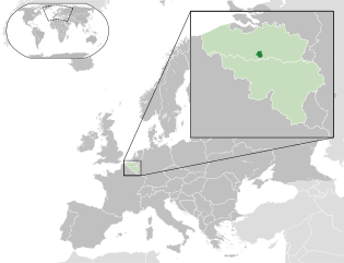
布鲁塞尔首都大区
| 布鲁塞尔首都大区 Région de Bruxelles-Capitale(法語) Brussels Hoofdstedelijk Gewest(荷蘭語) Region Brüssel-Hauptstadt(德語) | |||
|---|---|---|---|
| |||
 | |||
| 坐标:50°50′48″N 4°21′09″E / 50.8467°N 4.3525°E | |||
| 国家 | |||
| 社群 | |||
| 成立 | 1989年 | ||
| 首府 | 布鲁塞尔 | ||
| 政府 | |||
| • 行政部门 | 布鲁塞尔首都大区政府 | ||
| • 执政党 (2019年) | PS, DéFI, Ecolo, Open Vld, Vooruit, Groen | ||
| • 首长 | 鲁迪·费福尔特 (PS) | ||
| • 立法机构 | 布鲁塞尔首都大区议会 | ||
| • 议长 | 拉希德·马德兰 (PS) | ||
| 面积[1] | |||
| • 总计 | 161.38 平方公里(62.31 平方英里) | ||
| 人口(2022年1月1日)[2][3] | |||
| • 總計 | 1,222,637人 | ||
| • 密度 | 7,576人/平方公里(19,622人/平方英里) | ||
| 语言 | |||
| • 官方语言 | 荷兰语 法语 | ||
| NIS编码 | 04000 | ||
| ISO 3166码 | BE-BRU | ||
| 網站 | be.brussels | ||
布鲁塞尔首都大区(法語:Région de Bruxelles-Capitale;荷蘭語:Brussels Hoofdstedelijk Gewest;德語:Region Brüssel-Hauptstadt)是比利時的三个大区之一,位于该国中部,是弗拉芒布拉班特省的一块内飞地,面积161.38平方千米,人口逾120万,是比利时人口最稠密的大区。布鲁塞尔首都大区同时属于比利时法语社群和弗拉芒社群,法语和荷蘭語均为该大区官方语言,不过今天操法语者占多数(约占75%)。
历史
[编辑]1970年12月24日,“布鲁塞尔大区”(Région bruxelloise)一称出现在《比利时宪法》中,其规定比利时有三个大区:瓦隆大区、弗拉芒大區与布鲁塞尔大区。1971年,布鲁塞尔集聚体成立,其负责行使大区职能,但不具有大区的地位。然而由于各方未能达成协议,1978年《埃格蒙条约》实施未果,故1980年8月8日颁布的《关于机构改革的特别法》中没有任何与布鲁塞尔大区有关的条款。直到1988年,各方才达成协议,并于次年1月12日颁布特别法,建立了荷法双语的布鲁塞尔首都大区,取代了之前的布鲁塞尔集聚体。
区划
[编辑]
布鲁塞尔首都大区面积161.38平方千米,分为1个区(布鲁塞尔首都区,管辖范围与布鲁塞尔首都大区相同)与19个市镇。
| 纹章 | 市镇 | 面积(km²) | 人口(2017年1月1日)[4] |
|---|---|---|---|
| 安德莱赫特/昂德莱克特 Anderlecht |
17,74 | 118241 | |
| 奥德海姆/欧德盖姆 Oudergem/Auderghem |
9,03 | 33313 | |
| 圣阿哈塔-贝尔赫姆/贝尔凯姆-圣阿加特 Sint-Agatha-Berchem/Berchem-Sainte-Agathe |
2,95 | 24701 | |
| 布鲁塞尔 Brussel/Bruxelles |
32,61 | 176545 | |
| 埃特贝克 Etterbeek |
3,15 | 47414 | |
| 埃弗勒/埃韦尔 Evere |
5,02 | 40394 | |
| 福斯特/福雷 Vorst/Forest |
6,25 | 55746 | |
| 汉斯霍伦/甘索伦 Ganshoren |
2,46 | 24596 | |
| 埃尔瑟讷/伊克塞勒 Elsene/Ixelles |
6,34 | 86244 | |
| 耶特/热特 Jette |
5,04 | 51933 | |
| 库克尔贝赫/库克尔贝格 Koekelberg |
1,17 | 21609 | |
| 圣扬斯-莫伦贝克/莫伦贝克-圣让 Sint-Jans-Molenbeek/Molenbeek-Saint-Jean |
5,89 | 96629 | |
| 圣希利斯/圣吉勒 Sint-Gillis/Saint-Gilles |
2,52 | 50471 | |
| 圣约斯特滕诺德/圣若斯滕诺德 Sint-Joost-ten-Node/Saint-Josse-ten-Noode |
1,14 | 27115 | |
| 斯哈尔贝克/斯卡尔贝克 Schaarbeek/Schaerbeek |
8,14 | 133042 | |
| 于克尔/于克勒 Uccle/Ukkel |
22,91 | 82307 | |
| 瓦特马尔-博斯福德/瓦泰马勒-布瓦福尔 Watermaal-Bosvoorde/Watermael-Boitsfort |
12,93 | 24871 | |
| 圣兰布雷赫茨-沃吕沃/沃吕韦-圣朗贝尔 Woluwe-Saint-Lambert/Sint-Lambrechts-Woluwe |
7,22 | 55216 | |
| 圣彼得斯-沃吕沃/沃吕韦-圣皮埃尔 Sint-Pieters-Woluwe/Woluwe-Saint-Pierre |
8,85 | 41217 | |
| 布鲁塞尔首都大区 | 161,36 | 1191604 |
交通
[编辑]布鲁塞尔首都大区主要由四家交通运营商提供服务:
- 布鲁塞尔市际交通公司(STIB-MIVB):电车、地铁和公共汽车;
- 德莱恩(De Lijn):公共汽车;
- 瓦隆尼亚交通运营商(TEC):公共汽车;
- 比利时国家铁路公司(SNCB):火车。
参考文献
[编辑]- ^ be.STAT. bestat.statbel.fgov.be. [13 August 2020]. (原始内容存档于23 January 2021).
- ^ Mini-Bru | IBSA. ibsa.brussels. [17 March 2021]. (原始内容存档于9 March 2021).
- ^ Loop van de bevolking. Statbel. 2012-12-04 [2022-08-24]. (原始内容存档于2022-08-23) (荷兰语).
- ^ Population per municipality as of 1 January 2017 (XLS; 397 KB)
参见
[编辑]外部链接
[编辑]50°50′48″N 4°21′09″E / 50.8467°N 4.3525°E
| |||||||||||||||||||||||||||||||||||
| |||||||||||||||
| ||||||||||||||||||||||||||||||||||||||||||||||||||||||||||||||||||||||||||||||||||||||||
| ||||||||||||||||||||||
Text is available under the CC BY-SA 4.0 license; additional terms may apply.
Images, videos and audio are available under their respective licenses.


