安蒂波德斯群岛
| 安蒂德波斯群島 Antipodes Islands | |
|---|---|
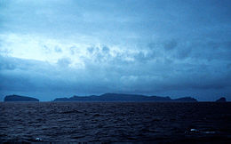
 從北方眺望安蒂德波斯群島 | |
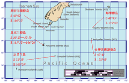
 安蒂德波斯群島、其他亞南極群島及紐西蘭南島的相對位置圖 | |
| 地理 | |
| 位置 | 斯圖爾特島東南方860公里(464海里) |
| 坐标 | 49°40′S 178°46′E / 49.667°S 178.767°E |
| 群岛 | 安蒂德波斯群島 |
| 主要島嶼 | 安蒂德波斯島 |
| 面積 | 21平方公里(8.1平方英里) |
| 最高海拔 | 366米(1201英尺) |
| 管轄 | |
| 人口统计 | |
| 人口 | 0[1](2006) |
| 其他资料 | |
| 自然保護區 | |
安蒂德波斯群島(Antipodes Islands)是屬於紐西蘭的無人島群。位於南緯49度41分東經178度48分的位置。位於斯圖爾特島的東南方650公里處。是紐西蘭的世界遺產亞南極群島的一部分[2]。
名稱來源是因為該群島接近英國格林威治天文台的對蹠點(相對極,Antipodes),但實際的對蹠點位置略有差異,比較接近法國北海岸的瑟堡-奧克特維爾或勒芒。
相關條目
外部連結
參考
- ^ Final counts – census night and census usually resident populations, and occupied dwellings - Area outside territorial authority (页面存档备份,存于互联网档案馆), 2006 Census, Statistics New Zealand. Retrieved 26 August 2010.
- ^ New Zealand Sub-Antarctic Islands. [2020-08-11]. (原始内容存档于2018-08-25).
| ||||||||||||||||||||
Text is available under the CC BY-SA 4.0 license; additional terms may apply.
Images, videos and audio are available under their respective licenses.

