For faster navigation, this Iframe is preloading the Wikiwand page for 雩時郡.

雩時郡

雩時郡
朝鮮語名稱轉寫
 • 諺文우시군
 • 漢字
 • 文化观光部2000年式 Usi-gun
 • 馬科恩-賴肖爾表記法 Usi-gun
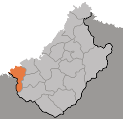
DPRK2006_Chagang-Usi.PNG
雩時郡在朝鲜民主主义人民共和国的位置
雩時郡
雩時郡
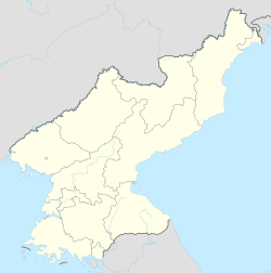
坐标:40°40′44″N 125°40′08″E / 40.679°N 125.669°E / 40.679; 125.669
國家 朝鮮民主主義人民共和國
行政區1邑、1勞動者區、22里
面积
 • 总计703.01 平方公里(271.43 平方英里)
人口(2008)
 • 總計42,919人
 • 密度61.1人/平方公里(158人/平方英里)

雩時郡朝鮮語:우시군雩時郡 Usi gun */?)是朝鮮民主主義人民共和國慈江道西部的一個郡,西鄰平安北道,北隔鴨綠江水豐水庫)與中國遼寧省相望。位於江南山脈北麓。其他主要河流包括忠滿江。面積703.01平方公里,2008年人口42,919人。[1]下分1邑、1勞動者區、22里。

歷史

[编辑]

1952年設郡。

参考文献

[编辑]
  1. ^ 朝鮮中央統計局,2008年人口普查結果页面存档备份,存于互联网档案馆),2009 年。
{{bottomLinkPreText}} {{bottomLinkText}}
雩時郡
Listen to this article

This browser is not supported by Wikiwand :(
Wikiwand requires a browser with modern capabilities in order to provide you with the best reading experience.
Please download and use one of the following browsers:

This article was just edited, click to reload
This article has been deleted on Wikipedia (Why?)

Back to homepage

Please click Add in the dialog above
Please click Allow in the top-left corner,
then click Install Now in the dialog
Please click Open in the download dialog,
then click Install
Please click the "Downloads" icon in the Safari toolbar, open the first download in the list,
then click Install
{{::$root.activation.text}}

Install Wikiwand

Install on Chrome Install on Firefox
Don't forget to rate us

Tell your friends about Wikiwand!

Gmail Facebook Twitter Link

Enjoying Wikiwand?

Tell your friends and spread the love:
Share on Gmail Share on Facebook Share on Twitter Share on Buffer

Our magic isn't perfect

You can help our automatic cover photo selection by reporting an unsuitable photo.

This photo is visually disturbing This photo is not a good choice

Thank you for helping!


Your input will affect cover photo selection, along with input from other users.

X

Get ready for Wikiwand 2.0 🎉! the new version arrives on September 1st! Don't want to wait?