蕉岭县
| 蕉岭县 | |
|---|---|
| 县 | |
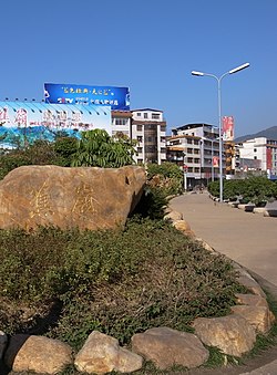
 蕉岭县城一景 | |
 蕉岭县的地理位置 | |
| 坐标:24°39′23″N 116°09′53″E / 24.65636°N 116.16472°E | |
| 国家 | |
| 隶属行政区 | 广东省梅州市 |
| 設立 | 明崇祯六年(1633年)建镇平县,民国3年(1914年)改今名 |
| 政府駐地 | 蕉城镇 |
| 下级行政区 | 列表
|
| 政府 | |
| • 县长 | 刘彩波 |
| 面积 | |
| • 总计 | 961.64 平方公里(371.29 平方英里) |
| 人口(2020) | |
| • 總計 | 戶籍人口 23.13萬 |
| 語言 | |
| • 母语(方言) | 客家话 |
| 时区 | 北京时间(UTC+8) |
| 郵政編碼 | 514100 |
| 電話區號 | 0753 |
| 車輛號牌 | 粤M |
| 行政区划代码 | 441427 |
| 舊稱 | 镇平县 |
| 網站 | www |
蕉岭县位于中国广东省东北部,韩江上游,属于梅州市管辖。东边和南边与梅县区相邻,西边与平远县相邻,北边与福建省龙岩市武平县、上杭县相邻,县政府驻镇北街12号。
行政区划
[编辑]三圳镇、文福镇、广福镇、新铺镇、蓝坊镇、南磜镇、蕉城镇、长潭镇和蕉华管理区。
地理
[编辑]蕉岭地处广东省东北部,属南亚热带季风气候。
| 蕉岭 (1981−2010) | |||||||||||||
|---|---|---|---|---|---|---|---|---|---|---|---|---|---|
| 月份 | 1月 | 2月 | 3月 | 4月 | 5月 | 6月 | 7月 | 8月 | 9月 | 10月 | 11月 | 12月 | 全年 |
| 平均高温 °C(°F) | 18.1 (64.6) |
18.5 (65.3) |
21.5 (70.7) |
25.9 (78.6) |
29.2 (84.6) |
31.6 (88.9) |
34.0 (93.2) |
33.5 (92.3) |
31.6 (88.9) |
28.9 (84.0) |
24.6 (76.3) |
19.8 (67.6) |
26.4 (79.6) |
| 日均气温 °C(°F) | 12.4 (54.3) |
13.8 (56.8) |
16.9 (62.4) |
21.5 (70.7) |
24.6 (76.3) |
26.9 (80.4) |
28.6 (83.5) |
28.1 (82.6) |
26.4 (79.5) |
23.1 (73.6) |
18.6 (65.5) |
13.6 (56.5) |
21.2 (70.2) |
| 平均低温 °C(°F) | 8.7 (47.7) |
10.5 (50.9) |
13.7 (56.7) |
18.4 (65.1) |
21.5 (70.7) |
23.8 (74.8) |
24.9 (76.8) |
24.7 (76.5) |
22.9 (73.2) |
19.2 (66.6) |
14.5 (58.1) |
9.4 (48.9) |
17.7 (63.8) |
| 平均降水量 mm(英寸) | 47.7 (1.88) |
105.5 (4.15) |
167.5 (6.59) |
224.4 (8.83) |
228.7 (9.00) |
286.8 (11.29) |
156.7 (6.17) |
207.5 (8.17) |
130.5 (5.14) |
32.4 (1.28) |
36.9 (1.45) |
34.1 (1.34) |
1,658.7 (65.29) |
| 平均相對濕度(%) | 71 | 76 | 79 | 80 | 80 | 82 | 77 | 79 | 77 | 71 | 68 | 67 | 76 |
| 数据来源:中国气象数据网[2] | |||||||||||||
教育
[编辑]- 学校
初中:新铺中学、同福中学、徐溪中学、广福中学、逢甲中学、蓝坊中学、南(北)礤中学、高思中学、城镇中学、蕉华中学、镇平中学、实验中学、蕉岭中学(只有初三)
高中:蕉岭中学、华侨中学
中专: 技工学校
历史
[编辑]蕉岭春秋战国时期属“百越之地”,公元前214年,秦始皇平定南越,蕉岭属南海郡龙川县。
明崇祯六年(1633年)建县,名镇平县。民国3年(1914年)镇平县改名为蕉岭县。
1965年蕉岭县属于梅县地区,1988年蕉岭县属梅州市管辖。
民族 人口
[编辑]蕉岭县以汉族客家人为主,有少量少数民族。 根據第七次全国人口普查數據,截至2020年11月1日零時,蕉嶺縣常住人口184355人,蕉嶺縣户籍人口23.13萬人,比上年減少584人,下降0.3%。全年出生人口2330 人,出生率10.05%;死亡人口1509人,死亡率6.52%;自然增長人口821人,自然增長率 3.54%。
语言
[编辑]蕉岭县大部分居民讲客家话。
经济
[编辑]

蕉岭的农业以水稻为主,比较有特色的是沙田柚、龙眼等种植业。工业比较有特色的是水泥、建材。蕉岭的矿藏资源也非常丰富,石灰石、粘土的储量较大,此外還有锰、铁、铝、钨、铜、铅、锌、锡、稀土金屬和煤礦藏。
2021年,蕉嶺縣地區生產總值為106.40億元,同比增長5.0%;兩年平均增長5.0%。
旅游
[编辑]蕉岭县旅游资源丰富,名胜古蹟有长潭旅游度假区、丘逢甲故居、龙潭飞瀑、蓬莱仙境、高台庵等。
交通
[编辑]相關人物
[编辑]参考文献
[编辑]- ^ 2023年蕉岭县统计用区划代码和城乡划分代码. 中华人民共和国国家统计局. 2023-06-30 (中文(中国大陆)).
- ^ 蕉岭- 气象数据 -中国气象数据网. Weather China. [2012-06-17]. (原始内容存档于2021-02-19) (中文(中国大陆)).
外部链接
[编辑]
| ||||||||||||
| |||||||||||||||||||||||||||||||||||||||||||||||||||||||||||||||||||||||||||||||||||||||
| ||||||||||||||||||||||||||||||||||||||||||||||||||||||||||||||||||||||||||||||||||||||||||||||||||||||||||||||||||||||||||||||||||
| ||||||||||||
Text is available under the CC BY-SA 4.0 license; additional terms may apply.
Images, videos and audio are available under their respective licenses.


