莫比尔 (阿拉巴马州)
| 莫比爾 Mobile | |||||
|---|---|---|---|---|---|
| 城市 | |||||
| 莫比爾市 | |||||
| |||||
| 綽號:港口之城、杜鵑之城、六旗之城 | |||||
 在縣內和州內的位置 | |||||
| 坐标:30°43′40″N 88°03′10″W / 30.727669°N 88.052672°W | |||||
| 國家 | |||||
| 州 | |||||
| 縣 | 莫比爾縣 | ||||
| 成立 | 1702年 | ||||
| 設鎮 | 1814年1月20日[1] | ||||
| 設市 | 1819年12月17日[2] | ||||
| 政府 | |||||
| • 类型 | 市长-议会制政府 | ||||
| • 市長 | Sandy Stimpson ( | ||||
| 面积 | |||||
| • 城市 | 180.07 平方英里(466.39 平方公里) | ||||
| • 陸地 | 139.48 平方英里(361.26 平方公里) | ||||
| • 水域 | 40.59 平方英里(105.14 平方公里) | ||||
| • 市區 | 222.8 平方英里(600 平方公里) | ||||
| • 都會區 | 1,644 平方英里(4,000 平方公里) | ||||
| 海拔(最低) | 10 英尺(3 公尺) | ||||
| 人口(2020年)[3] | |||||
| • 城市 | 187,041人 | ||||
| • 排名 | 全美第138 | ||||
| • 市区 | 321,907(全美第126) | ||||
| • 市区密度 | 1,458.3人/平方英里(563.0人/平方公里) | ||||
| • 都會區 | 430,197(全美第126) | ||||
| • CSA | 661,964(全美第76) | ||||
| 居民称谓 | 莫比爾人(Mobilian) | ||||
| 时区 | CST(UTC-6) | ||||
| • 夏时制 | CDT(UTC-5) | ||||
| 郵政編碼 | 郵編列表[4] | ||||
| 電話區號 | 251 | ||||
| FIPS編碼 | 01-50000 | ||||
| GNIS ID | 0155153 | ||||
| 州際公路 | |||||
| 輔助線 | |||||
| 美國國道 | |||||
| 機場 | 莫比爾區域機場 | ||||
| 網站 | www | ||||
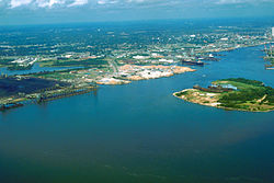
莫比尔(英語:Mobile,/moʊˈbiːl/,moh-BEEL,法语发音:[mɔ.bil])位于美国亚拉巴马州莫比尔县莫比尔湾西北沿岸,2010年人口195,111,是该州第三大城市和唯一的海港城市,也是莫比尔县的县治所在[5]。
城市的名字源自于建城之时该地区的印第安部落“Mobile”[6] 。美国第二大庆典——四旬斋前的狂欢节于1705年始于莫比尔[7]。
在过去的300年间,莫比尔的统治权曾六易其手,包括法国、英国、西班牙、亚拉巴馬共和国、美利坚联盟国和美利坚合众国[8]。
历史
1702年,莫比尔是莫比尔河畔的一座边境小镇和贸易站,也是法属路易斯安那最初的首府。1711年,为了远离洪水侵扰,莫比尔迁至莫比尔河和莫比尔湾的交汇处并更名为康德堡。法属路易斯安那的首府于1720年迁至比洛克西,然后又于1723年再次迁至新奥尔良[9] 。

在接下来的九十年间,莫比尔见证了商业和政治的巨大变化。1763年,根据《巴黎条约》,英国接替法国开始统治莫比尔。在此期间,莫比尔获得了迅速的发展并更名为夏洛特堡。英国的统治使莫比尔的文化逐渐迥异于法国在该地区建立的其它沿海城市。由于英国的严厉统治和民族歧视,原定居于此地的法国人纷纷迁居路易斯安那[9]。
1790年,西班牙人占领莫比尔。1813年,莫比尔已成为墨西哥湾沿岸第二大城市,美国将军詹姆斯·威尔金森率军夺取莫比尔。自19世纪中叶至20世纪初,莫比尔逐渐发展成为全球性的商业城市,莫比尔港也成为美国最繁忙的港口之一[9]。
1861年,美国内战爆发,莫比尔属于南部同盟。1864年,为免遭破坏,莫比尔在坚守一年之后向北方投降。1865年,莫比尔的一座军工厂发生爆炸,城市大片地区遭受毁坏[9]。
战后,莫比尔经济复苏并成为美国军用船只的建造港。第二次世界大战期间,莫比尔的陆军、海军和空军基地为城市带来了大量的人口[9]。
1960年代以来,莫比尔经济从造船业转向造纸业,军事基地也转为民用。
地理
气候
莫比尔位于墨西哥湾沿岸,拥有温和的亚热带气候,年平均气温19.8 °C(67.6 °F),年平均降水量1,700毫米(67.1英寸)。[10]莫比尔夏季暖和,冬季温和、潮湿。莫比尔经常受热带风暴和飓风袭击[11]。
| 阿拉巴马州莫比爾地區機場(1991–2020年正常值,1871年至今极端数据) | |||||||||||||
|---|---|---|---|---|---|---|---|---|---|---|---|---|---|
| 月份 | 1月 | 2月 | 3月 | 4月 | 5月 | 6月 | 7月 | 8月 | 9月 | 10月 | 11月 | 12月 | 全年 |
| 历史最高温 °C(°F) | 29 (84) |
29 (84) |
33 (91) |
34 (94) |
38 (100) |
39 (103) |
40 (104) |
41 (105) |
39 (103) |
37 (98) |
31 (88) |
28 (82) |
41 (105) |
| 平均最高温 °C(°F) | 24.3 (75.7) |
25.3 (77.6) |
28.3 (83.0) |
30.2 (86.3) |
33.4 (92.2) |
35.2 (95.4) |
35.9 (96.7) |
35.7 (96.2) |
34.3 (93.8) |
31.7 (89.1) |
27.8 (82.0) |
25.3 (77.6) |
36.6 (97.8) |
| 平均高温 °C(°F) | 16.4 (61.5) |
18.7 (65.6) |
22.1 (71.8) |
25.4 (77.8) |
29.4 (84.9) |
31.9 (89.4) |
32.7 (90.9) |
32.7 (90.8) |
30.8 (87.5) |
26.5 (79.7) |
21.2 (70.2) |
17.5 (63.5) |
25.4 (77.8) |
| 平均低温 °C(°F) | 4.8 (40.7) |
6.9 (44.4) |
10.0 (50.0) |
13.3 (56.0) |
17.7 (63.8) |
21.6 (70.8) |
22.8 (73.1) |
22.7 (72.9) |
20.4 (68.8) |
14.6 (58.2) |
8.7 (47.7) |
6.1 (43.0) |
14.1 (57.5) |
| 平均最低温 °C(°F) | −5.2 (22.7) |
−2.8 (26.9) |
−0.1 (31.9) |
4.4 (40.0) |
10.0 (50.0) |
17.3 (63.2) |
20.3 (68.6) |
19.6 (67.3) |
13.8 (56.8) |
4.7 (40.5) |
−0.7 (30.8) |
−2.6 (27.3) |
−6.1 (21.0) |
| 历史最低温 °C(°F) | −16 (3) |
−18 (−1) |
−6 (21) |
0 (32) |
6 (43) |
9 (49) |
17 (62) |
14 (57) |
6 (42) |
−1 (30) |
−6 (22) |
−13 (8) |
−18 (−1) |
| 平均降水量 mm(英寸) | 144 (5.66) |
114 (4.47) |
138 (5.44) |
145 (5.71) |
137 (5.39) |
166 (6.55) |
195 (7.69) |
174 (6.87) |
135 (5.30) |
100 (3.95) |
117 (4.60) |
138 (5.45) |
1,704 (67.08) |
| 平均降水天数(≥ 0.01 in) | 9.9 | 9.2 | 8.7 | 7.6 | 8.0 | 12.4 | 14.9 | 13.2 | 9.2 | 6.9 | 7.7 | 9.4 | 117.1 |
| 平均相對濕度(%) | 74 | 72 | 72 | 71 | 74 | 76 | 78 | 78 | 77 | 73 | 75 | 75 | 75 |
| 月均日照時數 | 158 | 155 | 211 | 255 | 300 | 287 | 246 | 254 | 233 | 254 | 193 | 145 | 2,691 |
| 数据来源1:National Oceanic and Atmospheric Administration(1981–2010年相对湿度)[10][12][13] | |||||||||||||
| 数据来源2:Danish Meteorological Institute(1931–1960日照)[14] | |||||||||||||
飓风
1979年9月12日,3级飓风弗里德里克袭击莫比尔市中心,遭成巨大损失,是该市历史上最严重的自然灾害。莫比尔花费了5年时间来重建被毁坏的城市。
2004年9月16日,3级飓风伊万在格尔夫肖尔斯登陆,莫比尔遭受其外围袭击,造成与1979年类似的重大损失。
人口统计
莫比尔是亚拉巴马州第二大都市圈——莫比尔都市圈的中心,整个都市圈拥有人口约429,622(2006年)。根据美国人口统计局2000年统计,莫比尔共有人口210,915,其中白人占50.40%、非裔美国人占46.29%、美国原住民占0.24%、亚裔美国人占1.52%。
政府
莫比尔民选政府由一名市长和一个有7名成员的市议会组成,理论上按照“弱市长强议会”的模式运作。城市选举每四年举行一次,最近的一次为2005年9月13日。
经济

莫比尔港正在经历历史上最大的扩展阶段,大量的集装箱处理和堆放设施正在兴建之中。莫比尔还将接受美国历史上最大的军事合同,一个超过2,000亿美元的空军油轮计划,它将为城市提供逾5,000个高薪职位并促近莫比尔成为美国繁荣的城市之一。亚拉巴马州快速发展的汽车工业也使莫比尔获得了2,000多个新的就业岗位。成千上万因为飓风卡特里娜而来莫比尔定居的撤离者也为城市经济的快速发展带来益处。莫比尔还是蒂森克虏伯钢铁厂的两个候选城市之一,一旦项目落户,将成为北美最大的钢铁厂,提供职业近3,000个。
交通

有三座机场可以为莫比尔提供服务:莫比尔地区机场、格尔夫波特-比洛克西国际机场和彭萨科拉地区机场。此外,还有莫比尔市区机场用于起降企业、货运和私人飞机和作为航空维护、维修基地。
教育
莫比尔公立学校由莫比尔县公立学校系统负责,而亚拉巴马州运作的亚拉巴马数学与自然科学学校则为高年级学生提供教育。此外,莫比尔还拥有大量私立学校,其中大部分属于天主教莫比尔教区。南亚拉巴马大学、春山學院和莫比尔大学提供高等教育。
荣誉
1995年,莫比尔被授予“全美城市奖”。
友好城市
参考文献
- information on metropolitan statistical areas and Mobile MSA[永久失效連結]
- Michael W. Fitzgerald. Urban Emancipation: Popular Politics in Reconstruction Mobile, 1860–1890. (Baton Rouge: LSU Press, 2002. 301 pp. ISBN 0-8071-2837-6.)
- ^ "An Act to provide for Government of the Town of Mobile. —Passed January 20, 1814." (Google Books) (页面存档备份,存于互联网档案馆). A Digest of the Laws of the State of Alabama: Containing The Statutes and Resolutions in Force at the end of the General Assembly in January, 1823. Published by Ginn & Curtis, J. & J. Harper, Printers, New-York, 1828. Title 62. Chapter XII. Pages 780-781.
- ^ "An Act to incorporate the City of Mobile. —Passed December 17, 1819." (Google Books) (页面存档备份,存于互联网档案馆). A Digest of the Laws of the State of Alabama: Containing The Statutes and Resolutions in Force at the end of the General Assembly in January, 1823. Published by Ginn & Curtis, J. & J. Harper, Printers, New-York, 1828. Title 62. Chapter XVI. Pages 784-791.
- ^ American FactFinder. United States Census Bureau. [2014-10-23]. (原始内容存档于2012-02-17).
- ^ Zip Code Lookup. USPS. [October 23, 2014]. (原始内容存档于2010-11-23).
- ^ USA: Alabama. CityPopulation.de. [2007-04-23]. (原始内容存档于2019-07-03).
- ^ Local History Information and Links. Mobile Genealogical Society. [2007-04-25]. (原始内容存档于2007-03-14).
- ^ Gulf Coast's oldest Mardi Gras. USA Today. 2004-01-26 [2007-02-08]. (原始内容存档于2011-05-24).
- ^ U.S. History, Retrieved May 5, 2007. [2007-05-06]. (原始内容存档于2007-08-10).
- ^ 9.0 9.1 9.2 9.3 9.4 History of the Area. SeniorsResourceGuide.com. [2007-05-05]. (原始内容存档于2007-09-28).
- ^ 10.0 10.1 Station: MOBILE, AL US USW00013894. National Oceanic and Atmospheric Administration. [2022-06-17]. (原始内容 (pdf)存档于2021-06-09).
- ^ Mobile's Climate. SeniorsResourceGuide.com. [2007-05-05]. (原始内容存档于2007-09-28).
- ^ NowData - NOAA Online Weather Data. National Oceanic and Atmospheric Administration. [2022-06-17]. (原始内容存档于2022-06-21).
- ^ Local Climatological Data Annual Summary with Comparative Data for MOBILE, ALABAMA (KMOB) (PDF). National Oceanic and Atmospheric Administration: 3. [2022-06-17]. (原始内容 (PDF)存档于2021-06-18).
- ^ Cappelen, John; Jensen, Jens. USA - Mobile, Alabama (PDF). Climate Data for Selected Stations (1931-1960). Danish Meteorological Institute: 316. [2013-02-23]. (原始内容存档 (PDF)于2013-01-16) (丹麦语).
- ^ 15.00 15.01 15.02 15.03 15.04 15.05 15.06 15.07 15.08 15.09 15.10 15.11 Online Directory: Alabama, USA (PDF). SisterCities.org. [2007-05-05]. (原始内容 (PDF)存档于2007-06-14).
- ^ Regional Overview (PDF). MobileChamber.com. [2007-MM-DD]. (原始内容 (PDF)存档于2007-06-14).
外部链接
| |||||||||||||||||||||||||||||||||||||||||||||
| ||||||||||||||||||||||||||||||||||||||||
| ||||||||||||||||||||||
Text is available under the CC BY-SA 4.0 license; additional terms may apply.
Images, videos and audio are available under their respective licenses.


