苗栗縣行政區劃
苗栗縣行政區劃係描述與今中華民國臺灣省苗栗縣相關之行政區劃沿革,及現今苗栗縣之行政區劃範圍。
目前苗栗縣劃分為2市、5鎮、11鄉(含1山地鄉),共有18個鄉鎮市,其中面積最大與最小的三級行政區分別是泰安鄉與竹南鎮,兩行政區面積分別為614.5127平方公里與37.5592平方公里;人口最多與最少的三級行政區分別是頭份市與獅潭鄉,2023年底兩行政區人口分別為106,350人與4,095人[1];人口密度最高與最低的三級行政區分別是竹南鎮與泰安鄉,2023年底兩行政區人口密度分別為每平方公里2,388人與每平方公里9人[1]。
沿革
[编辑]日治時期前
[编辑]明鄭時期,苗栗地區歸屬天興縣管理。清治時期,天興縣改稱為諸羅縣。1889年(清光緒15年),始設苗栗縣。
日治時期
[编辑]1895年日本統治台灣後,苗栗縣遭廢除。1901年到1908年間,另置苗栗廳,在日治時期行政單位與名稱屢有變遷。1950年台灣施行地方自治後,苗栗縣恢復設置,其行政區域沿用至今[2]。
中華民國時期
[编辑]民國三十九年(1950年)調整行政區域,將新竹縣所屬苗栗區的3鎮5鄉、竹南區的2鎮4鄉及大湖區的4鄉等18個鄉鎮合併獨立為苗栗縣,縣治設於苗栗鎮,轄4鎮、14鄉。民國四十年(1951年)後龍鄉改制後龍鎮、卓蘭鄉改制卓蘭鎮,民國七十年(1981年)苗栗鎮改制為縣轄市,民國一百零四年(2015年)頭份鎮改制為縣轄市,全縣轄有2市(苗栗市、頭份市)、5鎮(竹南鎮、後龍鎮、通霄鎮、苑裡鎮、卓蘭鎮)、11鄉(造橋鄉、西湖鄉、頭屋鄉、公館鄉、銅鑼鄉、三義鄉、大湖鄉、獅潭鄉、三灣鄉、南庄鄉、泰安鄉(山地鄉)),共有18個鄉鎮市。
《苗栗縣國土計畫》將縣內分為四個發展策略分區: 1.苗北生活圈(產業經貿):竹南鎮、頭份市,以竹南科學園區為核心,朝整併竹南頭份兩市鎮的都市計畫共同發展。 2.苗中生活圈(政經門戶):苗栗市、後龍鎮、公館鄉、造橋鄉、頭屋鄉、西湖鄉,以苗栗高鐵特區為核心,結合苗栗市政治中心地位。 3.苗南生活圈(人文科技):苑裡鎮、通霄鎮、銅鑼鄉、三義鄉,以銅鑼科學園區為核心,結合通苑的濱海資源、三義的慢城特色。 4.苗東生活圈(山景觀光):南庄鄉、卓蘭鎮、獅潭鄉、大湖鄉、泰安鄉、三灣鄉,以觀光為主軸,串聯各鄉的山林資源。
列表
[编辑]苗栗縣共有2市(又稱縣轄市)、5鎮、11鄉(含1山地鄉),以下資料為2023年底資料[1]。
| 區名 | 區域 代碼 |
面積 (km²) |
下轄 里數 |
下轄 鄰數 |
人口數 | 人口 消長 |
人口密度 (人/km²) |
地圖 |
|---|---|---|---|---|---|---|---|---|
| 苗栗市 | 10005010 | 37.8878 | 28 | 716 | 86,307 | +195 | 2,278 | .svg)
|
| 頭份市 | 10005020 | 53.3205 | 33 | 570 | 106,350 | +996 | 1,995 | .svg)
|
| 苑裡鎮 | 10005030 | 68.2473 | 25 | 362 | 43,728 | -199 | 641 | .svg)
|
| 通霄鎮 | 10005040 | 107.8486 | 24 | 394 | 31,300 | -535 | 290 | .svg)
|
| 竹南鎮 | 10005050 | 37.5592 | 25 | 518 | 89,708 | +1,344 | 2,388 | .svg)
|
| 後龍鎮 | 10005060 | 75.8079 | 23 | 368 | 34,113 | -245 | 450 | .svg)
|
| 卓蘭鎮 | 10005070 | 76.3153 | 11 | 176 | 15,212 | -302 | 199 | .svg)
|
| 大湖鄉 | 10005080 | 90.8396 | 12 | 179 | 12,964 | -255 | 143 | .svg)
|
| 公館鄉 | 10005090 | 71.4523 | 19 | 281 | 31,235 | -210 | 437 | .svg)
|
| 銅鑼鄉 | 10005100 | 78.3805 | 10 | 218 | 16,505 | -177 | 211 | .svg)
|
| 南庄鄉 | 10005110 | 165.4938 | 9 | 184 | 8,843 | -203 | 53 | .svg)
|
| 頭屋鄉 | 10005120 | 52.5046 | 8 | 120 | 9,788 | -160 | 186 | .svg)
|
| 三義鄉 | 10005130 | 69.3424 | 7 | 161 | 14,949 | -202 | 216 | .svg)
|
| 西湖鄉 | 10005140 | 41.0758 | 9 | 108 | 6,258 | -182 | 152 | .svg)
|
| 造橋鄉 | 10005150 | 47.9978 | 9 | 115 | 11,602 | -104 | 242 | .svg)
|
| 三灣鄉 | 10005160 | 52.2964 | 8 | 93 | 5,975 | -168 | 114 | .svg)
|
| 獅潭鄉 | 10005170 | 79.4324 | 7 | 98 | 4,095 | -54 | 52 | .svg)
|
| 泰安鄉 | 10005180 | 614.5127 | 8 | 64 | 5,643 | -96 | 9 | .svg)
|
| 苗栗縣 | 10005 | 1,820.3149 | 275 | 4,725 | 534,575 | -557 | 294 | 
|
- 人口消長計算方式為2023年底人口減去2022年底人口,負值以紅字表示,正值以藍字表示,沒有增長以綠字表示
- 各鄉鎮市人口密度以4捨5入至小數點前1位計之
- 2022年人口成長情形:
- 高度成長:(暫無)
- 穩定成長:頭份、竹南
- 成長停滯:泰安、獅潭、西湖
- 輕度流失:苑裡
- 高度流失:三灣、三義、公館、通霄、銅鑼、後龍、卓蘭、造橋、頭屋、大湖、西湖、南庄、苗栗
地圖
[编辑]| 苗栗縣行政區劃示意圖 |

|
圖集
[编辑]- 苗栗縣各鄉鎮市行政區圖集
-
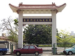 苗栗市苗栗鐵道文物展示館
 -
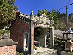
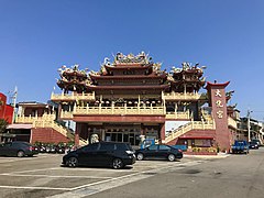 頭份市頭份大化宮
 -
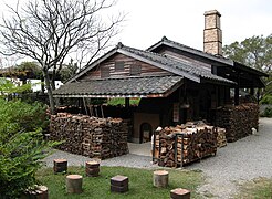 苑裡鎮華陶窯登窯及相思木柴
 -
 通霄鎮飛牛牧場
 -
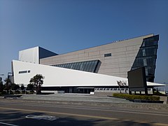 竹南鎮苗北藝文中心
 -
 後龍鎮外埔漁港
 -
 卓蘭鎮昭忠廟
 -
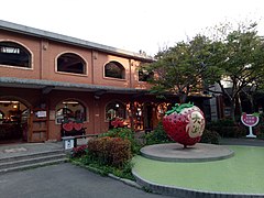 大湖鄉草莓文化館
 -
 公館鄉台灣油礦陳列館
 -
 銅鑼鄉臺灣客家文化館
 -
 南庄鄉南庄老街桂花巷
 -
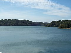
 頭屋鄉明德水庫
 -
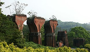 三義鄉龍騰斷橋
 -
-
 造橋鄉劍潭水庫的大石壩
 -
 三灣鄉永和山水庫
 -
 獅潭鄉汶水老街
 -
 泰安鄉泰安溫泉入口


.jpg)


參考文獻
[编辑]
| |||||||||||||||||||||||||||||||||

Text is available under the CC BY-SA 4.0 license; additional terms may apply.
Images, videos and audio are available under their respective licenses.
