苏雄镇
| 苏雄镇 | |
|---|---|
| 镇 | |
 阿兹觉村黑西洛沟和牛日河交汇处 | |
| 坐标:29°04′19″N 102°47′19″E / 29.07189°N 102.78868°E | |
| 国家 | |
| 上级行政区 | 甘洛县 |
| 政府駐地 | 阿兹觉村阿兹觉路49号 |
| 村级区划单位数 | |
| 时区 | 北京时间(UTC+8) |
| 行政区划代码 | 51 34 35 108 |
| 电话区号 | +86 (0)834 |
苏雄镇,原为苏雄乡,是中华人民共和国四川省凉山彝族自治州甘洛县下辖的一个乡镇级行政单位。[1]2020年6月,四川省政府批复同意撤销阿兹觉乡、苏雄乡,设立苏雄镇,以原苏雄乡和原阿兹觉乡阿兹觉村、吉乃彝各村、凉红村、治勒村所属行政区域为苏雄镇的行政区域[2]。
-
 龙门沟
龙门沟 -
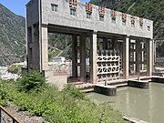
 苏雄水电站
苏雄水电站 -
 凉红水电站
凉红水电站 -
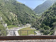
 埃岱火车站附近


行政区划
苏雄镇下辖以下地区:[3]
沙哈村、尔巴切村、尔苦村、瓦烘村和埃岱村。
参考资料
- ^ 2023年甘洛县统计用区划代码和城乡划分代码. 中华人民共和国国家统计局. 2023-06-30 (中文(中国大陆)).
- ^ 达州市、凉山州部分乡镇行政区划调整获批. 人民网-四川频道. 2020-06-12 [2020-09-01].
- ^ 2023年苏雄镇统计用区划代码和城乡划分代码. 中华人民共和国国家统计局. 2023-06-30 (中文(中国大陆)).
| |||||||||||||||||
Text is available under the CC BY-SA 4.0 license; additional terms may apply.
Images, videos and audio are available under their respective licenses.
Cover photo is available under {{::mainImage.info.license.name || 'Unknown'}} license.
Cover photo is available under {{::mainImage.info.license.name || 'Unknown'}} license.
Credit:
(see original file).
