突尼斯市
| 突尼斯 تونس Tunis | |
|---|---|
| 首都 | |
 突尼斯 | |
| 坐标:36°48′03″N 10°10′48″E / 36.8008°N 10.18°E | |
| 国家 | |
| 省 | 突尼斯省 |
| 政府 | |
| • 市长 | Souad Abderrahim |
| 面积 | |
| • 首都 | 212.63 平方公里(82.10 平方英里) |
| • 都會區 | 2,668 平方公里(1,030 平方英里) |
| 最高海拔 | 41 公尺(135 英尺) |
| 最低海拔 | 4 公尺(13 英尺) |
| 人口(2014年4月23日)[1] | |
| • 首都 | 638,845人 |
| • 密度 | 3,004人/平方公里(7,780人/平方英里) |
| • 市区 | 2,294,547 |
| • 都會區 | 2,643,695 |
| 居民称谓 | 阿拉伯语:تونسي Tounsi 法語:Tunisois |
| 时区 | CET(UTC+1) |
| 網站 | commune-tunis.gov.tn |

.jpg)


突尼斯(阿拉伯语:تونس;法語:Tunis)是北非突尼斯共和国的首都和最大城市,也是突尼斯省的省会所在地。突尼斯擁有大約2,700,000名居民。截至2020年,它是馬格里布地區的第四大城市(僅次於卡薩布蘭卡、阿爾及爾和的黎波里),也是阿拉伯世界第十六大城市。
突尼斯位於突尼西亞共和國北部的突尼斯湾(地中海一部)內,市區本身被突尼斯湖與西邊的潟湖包夾兩側,突尼斯運河貫穿市中心,在外港哈克阿瓦迪附近入海。沿著沿海平原和周圍的丘陵延伸。其核心是是迦太基古城過去的所在,目前則以突尼斯市的阿拉伯老城的名義登錄世界文化遺產。作為該國的首都,突尼斯是突尼西亞共和國政治和行政的中心,更是該國商業和文化活動的中心。
歷史
[编辑]突尼斯是迦太基古城過去的所在地。在七世紀後期時由伊斯蘭勢力所重新興建,正式名為突尼斯。
之後數個王朝陸續曾將這裡定為首都,使其成為一座具有國際色彩的歷史名城。
-
 突尼斯中心
突尼斯中心 -
 1955年的突尼斯體育館
 -
 空照圖
空照圖 -
 海灣區
海灣區 -
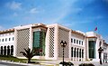 市政廳
市政廳


地理
[编辑]突尼斯市位於突尼斯湖西北方,該湖泊與地中海突尼斯灣建有運河相通。
氣候
[编辑]突尼斯市屬地中海型氣候(見柯本氣候分類法),夏季炎熱乾燥,冬季温和湿润。
| 突尼斯市 | |||||||||||||
|---|---|---|---|---|---|---|---|---|---|---|---|---|---|
| 月份 | 1月 | 2月 | 3月 | 4月 | 5月 | 6月 | 7月 | 8月 | 9月 | 10月 | 11月 | 12月 | 全年 |
| 平均高温 °C(°F) | 15.7 (60.3) |
16.5 (61.7) |
18.1 (64.6) |
20.7 (69.3) |
24.9 (76.8) |
29.0 (84.2) |
32.6 (90.7) |
32.7 (90.9) |
29.7 (85.5) |
25.2 (77.4) |
20.5 (68.9) |
16.7 (62.1) |
23.52 (74.34) |
| 日均气温 °C(°F) | 11.5 (52.7) |
12.0 (53.6) |
13.2 (55.8) |
15.6 (60.1) |
19.3 (66.7) |
23.2 (73.8) |
26.3 (79.3) |
26.8 (80.2) |
24.4 (75.9) |
20.4 (68.7) |
15.9 (60.6) |
12.5 (54.5) |
18.43 (65.17) |
| 平均低温 °C(°F) | 7.2 (45.0) |
7.4 (45.3) |
8.3 (46.9) |
10.4 (50.7) |
13.7 (56.7) |
17.3 (63.1) |
20.0 (68.0) |
20.8 (69.4) |
19.0 (66.2) |
15.5 (59.9) |
11.3 (52.3) |
8.2 (46.8) |
13.26 (55.87) |
| 平均降水量 mm(英寸) | 59.3 (2.33) |
57.0 (2.24) |
47.2 (1.86) |
38.0 (1.50) |
22.6 (0.89) |
10.4 (0.41) |
3.1 (0.12) |
7.1 (0.28) |
32.5 (1.28) |
65.5 (2.58) |
56.0 (2.20) |
66.8 (2.63) |
465.5 (18.33) |
| 平均降水天数 | 9 | 8 | 8 | 6 | 4 | 2 | 1 | 1 | 4 | 7 | 7 | 8 | 65 |
| 月均日照時數 | 145.7 | 165.3 | 198.4 | 225.0 | 282.1 | 309.0 | 356.5 | 328.6 | 258.0 | 217.0 | 174.0 | 148.8 | 2,808.4 |
| 数据来源:世界氣象組織,[2]香港天文台 for data of avg. precipitation days and sunshine hours[3] | |||||||||||||
經濟
[编辑]公共交通
[编辑]


不断发展中的大都市地区接收着巴士、轻轨、火车等公共交通网络服务。多车道高速公路环绕着城市。当地的私人汽车服务越来越兴旺,而公路为其发展提供了有效的服务。突尼斯 -迦太基国际机场则负责着全城的航空事业。
突尼斯輕軌(阿拉伯语:المترو الخفيف لمدينة تونس)、TGM(Tunis-Goulette-Marsa)和巴士都为当地交通的发展作出了贡献,通过突尼西亞鐵路公司(SNCFT)与全国的其他地区相连。突尼斯运输公司(STT)[4]和交通部(机场)都是重要的相关机构。[5] The A1 motorway connects Tunis with Sfax to the south, and the A3 with Oued Zarga and Béja to the west, while the A4 is the link with Bizerte.
截至二十一世纪初,突尼斯的公共交通系统都是在突尼斯运输公司(STT)的管理下建设的。当地共有200条巴士路线,第一条轻铁线于1995年开放。突尼斯轻轨网络自此以后逐渐发展至郊区。北郊的铁路线跨过了湖面,与城市相连的同时将湖面划为两半。此外,政府计划于2009年为大突尼斯营建新的公共交通系统——RTS(快速铁路网络)。类似于法国的区域快铁(RER),它将通过各种轨道携带成千上万的旅客从突尼斯遥远的郊区抵达市中心。[6]它將被劃分為一些行,其優先級將基於某些標準,如人口密度和特定區域的覆蓋率不足。其中的優先事項如下:Tunis-BorjCédria(23公里)已經規劃了現代化和電氣化;Tunis-Mohamedia-Fouchana(19.4公里);突尼斯 - 馬努巴 - 米尼拉(19.2公里);Tunis-Ezzouhour-SidiHassineSéjoumi(13.9公里)。此外,TGM將整合到輕軌網絡和圍繞Ayn Zaghouan和Bhar Lazrag(8.4公里)的新線路。這樣的操作需要升級碼頭的TGM站,以便它們適用於輕軌列車。其他項目包括Ennasr城市(8.4公里)和突尼斯 - Ettadhamen延伸至Mnihla(1.7公里)。
参考资料
[编辑]- ^ Tunisia: Governorates, Major Cities, Communes & Urban Agglomerations. Population Statistics, Maps, Charts, Weather and Web Information. 1984-05-30 [2020-08-24]. (原始内容存档于2020-04-07).
- ^ Weather Information for Tunis-Carthage. WMO. [2010-01-21]. (原始内容存档于2020-11-19).
- ^ Climatological Information for Tunis, Tunisia. Hong Kong Observatory. [2012-02-06]. (原始内容存档于2019-10-23).
- ^ e-Market place |. Snt.com.tn. 2012-11-13 [2013-03-12]. (原始内容存档于2002-04-02).
- ^ http://www.oaca.nat.tn/ (页面存档备份,存于互联网档案馆) OACA
- ^ Chokri Gharbi, La métamorphose d'une capitale au cœur de la Méditerranée, La Presse de Tunisie
| ||||||||||||
| ||||||||||||||||||||||
Text is available under the CC BY-SA 4.0 license; additional terms may apply.
Images, videos and audio are available under their respective licenses.
