For faster navigation, this Iframe is preloading the Wikiwand page for 白沙頭.

白沙頭

22°28′08″N 114°14′01″E / 22.469021°N 114.233722°E / 22.469021; 114.233722

八仙嶺俯瞰船灣淡水湖,主壩連接白沙頭

白沙頭(英語:Pak Sha Tau,曾稱Harbour Island[1])是香港昔日的一個島嶼,位於新界大埔區船灣淡水湖南端,由主壩與大尾篤連接,而副壩則連接東頭洲

白沙頭原本是船灣伯公咀對出東頭洲以西的一個面積0.2平方哩的小島,稱為白沙頭洲,又名「三門塘洲」,在1960年開始興建船灣淡水湖時,在大尾篤、白沙頭洲、東頭洲及伯公咀之間興建堤壩,再將壩內海水抽乾用作儲水之用。島嶼東部尖出稱為「白排角」,而西部銳伸的南端稱為「白沙頭咀」,位於兩者之間的是「牛環套灣」;島嶼北部的海灣原名為「三門仔灣」,是三門仔村舊址;中部高峰稱為「三門墩」。

赤門海峽北岸的「黃竹角咀組」泥盆紀沉積岩是香港目前發現最古老的岩石,由黃竹角咀向西南一直伸延至白沙頭。
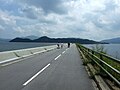
站外鏈結

[编辑]


  1. ^ Hong Kong Historic Maps - Reference 1928 (UK National Archives). [2022-05-25]. (原始内容存档于2022-06-02). 
{{bottomLinkPreText}} {{bottomLinkText}}
白沙頭
Listen to this article

This browser is not supported by Wikiwand :(
Wikiwand requires a browser with modern capabilities in order to provide you with the best reading experience.
Please download and use one of the following browsers:

This article was just edited, click to reload
This article has been deleted on Wikipedia (Why?)

Back to homepage

Please click Add in the dialog above
Please click Allow in the top-left corner,
then click Install Now in the dialog
Please click Open in the download dialog,
then click Install
Please click the "Downloads" icon in the Safari toolbar, open the first download in the list,
then click Install
{{::$root.activation.text}}

Install Wikiwand

Install on Chrome Install on Firefox
Don't forget to rate us

Tell your friends about Wikiwand!

Gmail Facebook Twitter Link

Enjoying Wikiwand?

Tell your friends and spread the love:
Share on Gmail Share on Facebook Share on Twitter Share on Buffer

Our magic isn't perfect

You can help our automatic cover photo selection by reporting an unsuitable photo.

This photo is visually disturbing This photo is not a good choice

Thank you for helping!


Your input will affect cover photo selection, along with input from other users.

X

Get ready for Wikiwand 2.0 🎉! the new version arrives on September 1st! Don't want to wait?