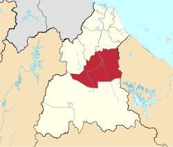
瓜拉吉赖县
| 瓜拉吉赖县 | |
|---|---|
| Jajahan Kuala Krai | |
| 其他文字轉寫 | |
| • 英文 | Kuala Krai District |
| • 淡米尔文 | கோலா கிராய் |
 瓜拉吉赖县在吉兰丹的位置 | |
 | |
瓜拉吉赖县在马来西亚的位置 | |
| 坐标:5°30′N 102°10′E / 5.500°N 102.167°E | |
| 国家 | |
| 州属 | |
| 成立新县 | 1977年 |
| 政府所在地 | 瓜拉吉赖 |
| 地方政府 | 瓜拉吉赖县议会(北部) 达蓬县议会(南部) |
| 政府 | |
| • 县长 | 祖基菲里(Zulkifle Abdul Rahman)[1] |
| 面积 | |
| • 总计 | 2,329 平方公里(899 平方英里) |
| 人口(2010) | |
| • 總計 | 109,461人 |
| • 密度 | 47人/平方公里(122人/平方英里) |
| 时区 | 马来西亚标准时间(UTC+08:00) |
| • 夏时制 | 无(UTC+08:00) |
| 邮政编码 | 18xxx |
| 电话区号 | +6-09-9 |
| 车牌 | D |
瓜拉吉赖县(馬來語:Jajahan Kuala Krai),是马来西亚吉兰丹州东南部的一个县。其面积为2,329平方公里[2],人口于2010年为109,461[3]。该县北临丹那美拉县和马樟县,西临日里县,东临登嘉楼州勿述县和乌鲁登嘉楼县,南临话望生县。瓜拉吉赖县除了县府瓜拉吉赖外,还有达蓬、玛力勿莱等市镇。
历史
[编辑]瓜拉吉赖县原是乌鲁吉兰丹县的一部分,该县涵盖现在的瓜拉吉赖县、话望生县和日里县的瓜拉峇拉。1977年9月1日,瓜拉吉赖县正式升格为县。[4]
行政区划
[编辑]
瓜拉吉赖县下辖3个区(Daerah)、15个巫金(Mukim)。[5][6]
| 区(Daerah) | 巫金(Mukim) | 人口[7] |
|---|---|---|
| 峇都孟哥邦 Batu Mengkebang |
|
63,575 |
| 乌落而榄 Olak Jeram |
|
27,486 |
| 达蓬 Dabong |
|
13,173 |
市镇
[编辑]瓜拉吉赖县内有1个市(Bandar)。[6]
人口分布
[编辑]瓜拉吉赖县总人口于2010年为109,461人,占了全吉兰丹州总人口(1,539,601)约7.11%。下列数据以2010年马来西亚人口普查为准。[3]
| 2010年瓜拉吉赖县族群比例 | ||||
|---|---|---|---|---|
| 族群 / 国籍 | 百分比 | |||
| 马来人 | 90.43% | |||
| 其它土著 | 0.05% | |||
| 华人 | 3.86% | |||
| 印度人 | 0.88% | |||
| 其他 | 0.11% | |||
| 非马来西亚公民 | 4.66% | |||
| 族群 | 2010 | |
|---|---|---|
| 人口 | 百分比 | |
| 马来人 | 98990 | 90.43% |
| 其他土著 | 59 | 0.05% |
| 华人 | 4220 | 3.86% |
| 印度人 | 967 | 0.88% |
| 其他 | 120 | 0.11% |
| 马来西亚公民总数 | 104356 | 95.34% |
| 非马来西亚公民总数 | 5105 | 4.66% |
| 总数 | 109461 | 100.00% |
参见
[编辑]注释
[编辑]参考
[编辑]- ^ User, Super. Laman Web Rasmi Pejabat Tanah Dan Jajahan Kuala Krai – Perutusan Ketua Jajahan. Ptjkk.kelantan.gov.my. [2019-03-15]. (原始内容存档于2018-11-01).
- ^ Profail Jajahan Kuala Krai. Pejabat Tanah dan Jajahan Kuala Krai. [2007-10-23]. (原始内容存档于2008-03-12).
- ^ 3.0 3.1 Taburan Penduduk dan Ciri-ciri Asas Demografi 2010. Putrajaya: Jabatan Perangkaan Malaysia. 2011. ISBN 978-983-9044-54-6.
- ^ Info Kuala Krai. Majlis Daerah Kuala Krai. [2017-01-10]. (原始内容存档于2021-01-27).
- ^ NW, Super User. Latar Belakang Jajahan. ptjb.kelantan.gov.my. [2022-05-05]. (原始内容存档于2021-05-06) (ms-my).
- ^ 6.0 6.1 Kod dan Nama Sempadan Pentadbiran Tanah, Unique Parcel Identifier (UPI) KELANTAN (PDF). Jawatankuasa Teknikal Standard MyGDI (JTSM). 2011. (原始内容存档 (PDF)于2021-08-03).
- ^ Population Distribution by Local Authority Areas and Mukims, 2010 (page 1 & 8) (PDF). 马来西亚国家统计局. [2013-07-19]. (原始内容 (PDF)存档于2015-02-05) (英语).
外部链接
[编辑]
| ||||||||||||||||||||||||||||||
| ||||||||||||||||||||||||||||||||||||||||||||||||||||||||||||||||||
Text is available under the CC BY-SA 4.0 license; additional terms may apply.
Images, videos and audio are available under their respective licenses.


