火地省 (阿根廷)
| 火地、南極及南大西洋諸島 Tierra del Fuego, Antártida e Islas del Atlántico Sur | |||
|---|---|---|---|
| 省份 | |||
| |||
| 綽號:世界的盡頭(Fin del Mundo) | |||
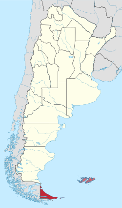
 火地省在阿根廷的位置 | |||
| 坐标:54°21′43″S 67°38′17″W / 54.362°S 67.638°W | |||
| 國家 | |||
| 首府 | 烏斯懷亞 | ||
| 縣 | 4 | ||
| 地方政府 | 5 | ||
| 政府 | |||
| • 省長 | 羅薩那·貝爾托尼(PJ/FpV) | ||
| • 眾議員 | 5 | ||
| • 參議員 | 3 | ||
| 面积 第23位 | |||
| • 总计 | 21,263 平方公里(8,210 平方英里) | ||
| 人口(2010[1]) | |||
| • 總計 | 127,205人 | ||
| • 排名 | 第24位 | ||
| • 密度 | 5.98人/平方公里(15.5人/平方英里) | ||
| 居民称谓 | fueguino | ||
| 时区 | ART(UTC−3) | ||
| ISO 3166码 | AR-V | ||
| HDI(2016年) | 0.887 非常高(第1位)[2] | ||
| 網站 | www | ||
火地、南極和南大西洋諸島省(西班牙語:Provincia de Tierra del Fuego, Antártida e Islas del Atlántico Sur)簡稱「火地省」,位於南美洲國家阿根廷南部,地处大火地島東部,是該國的23個行省之一,首府為烏斯懷亞。當地人暱稱其作「fueguino」或「Fin del Mundo」(世界之末端)。雖然此省實際管轄的地區僅包括火地島東部及周邊島嶼,但阿根廷公告的疆域則包括马尔维纳斯群岛、南佐治亞及南三文治群島、南奧克尼群島及阿根廷南極屬地。
歷史
[编辑]原住民已在該地生活超過12000年。1520年,麥哲倫「發現」該地。他最初將此地命名為煙地,後來則改成現名。當時,歐洲人在該地發現了大約一萬名原住民,而他們分屬於雅加人、阿拉卡盧夫人、瑟爾科南人和侯斯人四部。[3] 然而在歐洲人發現該地的五十年後,原住民人口因麻疹和天花等從歐洲人傳播至當地的高死亡率傳染病急跌至約350人。[4][5] 佩德羅·甘博阿·德·薩爾米恩托等人曾試於此地建立居民點,唯無功而返。
阿根廷獨立後,此地仍然由原住民控制。1870年代,阿根廷發動第二次征服沙漠,近乎完全摧毁原住民人口後,阿根廷於1885年將此地納入其領土,並設置一聯邦直轄區。自此區發現黃金並爆發淘金熱,並且畜牧業蓬勃發展下,歐洲移民大量湧入。1960年,阿根廷政府於此地建立了國家公園。該區在1990年才升格為省,是全阿根廷最後一個聯邦直轄區。
地理
[编辑]
此省幅員廣大,其地理可分為三部分展述,分別為:火地島、阿根廷南極屬地和南大西洋諸島。
阿根廷屬火地島地理
[编辑]該部分由火地島的東部共38.57%的土地(共18,507.3平方公里)及艾斯塔多島組成。該處氣候屬於海洋性氣候。[6]夏季短而涼快,冬季則漫長且潮濕。風勢清勁,降雨少。該地雪綫則位於海拔700米。
| 烏斯懷亞國際機場 | |||||||||||||
|---|---|---|---|---|---|---|---|---|---|---|---|---|---|
| 月份 | 1月 | 2月 | 3月 | 4月 | 5月 | 6月 | 7月 | 8月 | 9月 | 10月 | 11月 | 12月 | 全年 |
| 历史最高温 °C(°F) | 29.5 (85.1) |
28.9 (84.0) |
25.6 (78.1) |
22.2 (72.0) |
20.3 (68.5) |
19.0 (66.2) |
17.5 (63.5) |
18.0 (64.4) |
22.3 (72.1) |
21.2 (70.2) |
26.3 (79.3) |
29.0 (84.2) |
29.5 (85.1) |
| 平均高温 °C(°F) | 13.9 (57.0) |
13.7 (56.7) |
12.2 (54.0) |
9.6 (49.3) |
6.5 (43.7) |
4.6 (40.3) |
4.2 (39.6) |
5.6 (42.1) |
8.2 (46.8) |
10.5 (50.9) |
12.1 (53.8) |
13.4 (56.1) |
9.5 (49.1) |
| 日均气温 °C(°F) | 9.6 (49.3) |
9.3 (48.7) |
7.7 (45.9) |
5.7 (42.3) |
3.2 (37.8) |
1.7 (35.1) |
1.3 (34.3) |
2.2 (36.0) |
4.1 (39.4) |
6.2 (43.2) |
7.8 (46.0) |
9.1 (48.4) |
5.7 (42.3) |
| 平均低温 °C(°F) | 5.4 (41.7) |
5.3 (41.5) |
3.9 (39.0) |
2.3 (36.1) |
0.1 (32.2) |
−1.4 (29.5) |
−1.7 (28.9) |
−1 (30) |
0.5 (32.9) |
2.3 (36.1) |
3.6 (38.5) |
4.9 (40.8) |
2.0 (35.6) |
| 历史最低温 °C(°F) | −2.0 (28.4) |
−4.0 (24.8) |
−4.3 (24.3) |
−7.3 (18.9) |
−20.2 (−4.4) |
−18.2 (−0.8) |
−21.0 (−5.8) |
−19.6 (−3.3) |
−10.6 (12.9) |
−6.1 (21.0) |
−6.0 (21.2) |
−3.7 (25.3) |
−21.0 (−5.8) |
| 平均降水量 mm(英寸) | 39.0 (1.54) |
45.2 (1.78) |
52.3 (2.06) |
56.1 (2.21) |
53.4 (2.10) |
48.3 (1.90) |
36.4 (1.43) |
45.2 (1.78) |
41.7 (1.64) |
35.0 (1.38) |
34.6 (1.36) |
42.5 (1.67) |
529.7 (20.85) |
| 平均降水天数(≥ 0.1 mm) | 14 | 13 | 14 | 13 | 12 | 12 | 11 | 12 | 12 | 12 | 12 | 14 | 151 |
| 平均降雪天数 | 0.3 | 0.1 | 2 | 2 | 5 | 8 | 7 | 9 | 7 | 5 | 3 | 1 | 49.4 |
| 平均相對濕度(%) | 75 | 76 | 78 | 80 | 81 | 82 | 82 | 80 | 76 | 73 | 72 | 74 | 77 |
| 月均日照時數 | 167.4 | 146.9 | 133.3 | 102.0 | 68.2 | 42.0 | 55.8 | 83.7 | 123.0 | 164.3 | 180.0 | 167.4 | 1,434 |
| 可照百分比 | 32.0 | 34.5 | 33.5 | 31.5 | 25.7 | 18.5 | 22.5 | 27.5 | 34.0 | 37.5 | 37.0 | 28.5 | 30.2 |
| 数据来源1:NOAA,[7] Secretaria de Mineria (extremes and sun, 1901–1990),[8] Oficina de Riesgo Agropecuario (extremes 1970–present)[9] | |||||||||||||
| 数据来源2:Servicio Meteorológico Nacional (precipitation days)[10] UNLP (snowfall data)[11] | |||||||||||||
阿根廷南極屬地地理
[编辑]該地包括了西經25度至西經74度之間,南緯60度以南,以南極為中心的扇形地區[12]。面積965,597平方公里。然而,根據《南極條約》,阿根廷對該地的領土主權要求都處在被凍結狀態。該地北部位於副極地氣候而南部則屬於寒帶。[13]氣候寒冷,平均氣溫低於0°C ,且全年下雪。[14]
南大西洋諸島地理
[编辑]阿根廷宣稱此省控制的南大西洋諸島包括:福克蘭群島、南奧克尼群島、南佐治亞及南三明治群島等地。[15]除南奧克尼群島外,南大西洋諸島現時全由英國實際控制。此處最高峰為帕吉特山,標高2934米[16]。氣候為寒冷、多風且潮濕的海洋性氣候,[17]天氣都很多變。其中,福克蘭群島氣候相對和緩,全年僅會出現出現零星小雪[18];南佐治亞及南三明治群島等地則較為惡劣。南佐治亞大部分降水皆是雪。該島大部分時間有狂暴50度之稱的强風,僅有少量時間氣候溫和。此等惡劣的氣候,尤其在下降風形成時,使得船隻難於停泊。[19]
行政區劃
[编辑]該省下轄四縣,包括:烏斯懷亞縣、里奧格蘭德縣、阿根廷南極屬地及南大西洋諸島。[15]其中,僅烏斯懷亞縣和里奧格蘭德縣由阿根廷實際控制。
參見
[编辑]參考來源
[编辑]- ^ Censo 2010 Argentina resultados provisionales: mapas. [2016-10-28]. (原始内容存档于2012-09-01).
- ^ Información para el desarrollo sostenible: Argentina y la Agenda 2030 (PDF). United Nations Development Programme: 155. [2017-08-25]. (原始内容 (PDF)存档于2017-08-25) (西班牙语).
- ^ Tierra Del Fuego 互联网档案馆的存檔,存档日期2008-01-28.
- ^ "Yahgan & Ona - The Road to Extinction" 互联网档案馆的存檔,存档日期2006-10-02., Cultural Survival Quarterly
- ^ "La Patagonia Trágica" (页面存档备份,存于互联网档案馆), Argentine Schools curriculum
- ^ Météo et climat à Ushuaïa en Argentine. [2017-03-13]. (原始内容存档于2017-03-14) (法语)..
- ^ Ushuaia AERO I Climate Normals 1961–1990. National Oceanic and Atmospheric Administration. [2015-10-20]. (原始内容存档于2020-08-21).
- ^ Provincia de Tierra del Fuego - Clima Y Meteorologia: Datos Meteorologicos Y Pluviometicos. Secretaria de Mineria de la Nacion (Argentina). [2013-04-07]. (原始内容存档于2015-01-19) (西班牙语).
- ^ Ushuaia, Tierra del Fuego. Estadísticas meteorológicas decadiales. Oficina de Riesgo Agropecuario. [2015-07-13]. (原始内容存档于2019-08-08) (西班牙语).
- ^ Valores Medios de Temperature y Precipitación-Tierra del Fuego: Ushuaia. Servicio Meteorológico Nacional. [2015-10-12]. (原始内容存档于2017-09-04) (西班牙语).
- ^ Datos bioclimáticos de 173 localidades argentinas. Atlas Bioclimáticos. Universidad Nacional de La Plata. [2014-04-05]. (原始内容存档于2019-08-25) (西班牙语).
- ^ Beck, Peter J. The international politics of Antarctica. Routledge. 1986: 第119页 [2017-09-07]. ISBN 0709932391. (原始内容存档于2017-05-10).
- ^ Regiones argentinas. Embassy of Argentina in the Socialist Republic of Vietnam. [2016-11-11]. (原始内容存档于2016-11-11) (西班牙语).
- ^ Antártida. Ministerio de Ambiente y Desarrollo Sustentable de la Nación. [2016-11-11]. (原始内容存档于2016-11-11) (西班牙语).
- ^ 15.0 15.1 División política (页面存档备份,存于互联网档案馆) - Gobierno de la provincia de Tierra del Fuego, Antártida e Islas del Atlántico Sur
- ^ Headland, Robert. The Island of South Georgia. CUP Archive. 1992: 195–197. ISBN 978-0-521-42474-5.
- ^ Klügel, Andreas. Atlantic Region. Rosemary Gillespie; David Clague (编). Encyclopedia of Islands. Berkeley: University of California Press. 2009: 66. ISBN 978-0-520-25649-1.
- ^ Central Intelligence Agency. Falkland Islands (Malvinas) – Geography. The CIA World Factbook 2012. New York: Skyhorse Publishing, Inc. 2011. ISBN 978-1-61608-332-8.
- ^ Climates to travel. Climate - South Georgia. [2017-09-07]. (原始内容存档于2017-08-30).
| ||||||||||||||
| |||||||||||||||||
Text is available under the CC BY-SA 4.0 license; additional terms may apply.
Images, videos and audio are available under their respective licenses.


