For faster navigation, this Iframe is preloading the Wikiwand page for 洪保德峰.

洪保德峰

洪保德峰
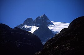
Pico Humboldt as seen from the Coromoto-La Verde trail.
最高点
海拔4940m
地理
位置梅里达
山脈梅里达内华达山脉
攀山
首次登頂1911 by Alfredo Jahn
最简路线英语Normal routeLaguna del Suero

洪保德峰Pico Humboldt)是委内瑞拉的第二高峰,海拔4,940米。洪保德峰位于梅里达内华达山脉,有一个遥相呼应的邦普朗峰。山峰名称来自德国探险家和自然主义者亚历山大·冯·洪堡

冰川

[编辑]

邦普朗峰被东科罗莫托冰川和西弗斯冰川所包围,这两个冰川是委内瑞拉存留下来的5个冰川中的两个(另外三个在玻利瓦尔峰)。

参考资料

[编辑]
  • Jahn A, Observaciones glaciológicas de los Andes venezolanos. Cult. Venez. 1925, 64:265-80
{{bottomLinkPreText}} {{bottomLinkText}}
洪保德峰
Listen to this article

This browser is not supported by Wikiwand :(
Wikiwand requires a browser with modern capabilities in order to provide you with the best reading experience.
Please download and use one of the following browsers:

This article was just edited, click to reload
This article has been deleted on Wikipedia (Why?)

Back to homepage

Please click Add in the dialog above
Please click Allow in the top-left corner,
then click Install Now in the dialog
Please click Open in the download dialog,
then click Install
Please click the "Downloads" icon in the Safari toolbar, open the first download in the list,
then click Install
{{::$root.activation.text}}

Install Wikiwand

Install on Chrome Install on Firefox
Don't forget to rate us

Tell your friends about Wikiwand!

Gmail Facebook Twitter Link

Enjoying Wikiwand?

Tell your friends and spread the love:
Share on Gmail Share on Facebook Share on Twitter Share on Buffer

Our magic isn't perfect

You can help our automatic cover photo selection by reporting an unsuitable photo.

This photo is visually disturbing This photo is not a good choice

Thank you for helping!


Your input will affect cover photo selection, along with input from other users.

X

Get ready for Wikiwand 2.0 🎉! the new version arrives on September 1st! Don't want to wait?