For faster navigation, this Iframe is preloading the Wikiwand page for 沙上区.

沙上区

沙上區
自治區
韓語轉寫
 • 諺文사상구
 • 漢字沙上區
 • 文化观光部2000年式Sasang-gu
 • 馬科恩-賴肖爾表記法Sasang-gu
沙上區全景
沙上區全景
沙上區旗幟
旗幟
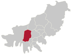
沙上區在釜山廣域市的位置
沙上區在釜山廣域市的位置
坐标:35°09′04″N 128°59′24″E / 35.1511°N 128.99°E / 35.1511; 128.99
國家 大韓民國
地區嶺南地方
省級行政區 釜山廣域市
行政區劃12行政洞、8法定洞
政府
 • 行政机构沙上區廳
 • 區廳長趙柄吉朝鲜语조병길國民力量 國民力量
 • 國會議員張濟元國民力量 國民力量
面积
 • 总计36.06 平方公里(13.92 平方英里)
人口(2021年)
 • 總計208,298人
 • 密度5,776人/平方公里(14,961人/平方英里)
區樹赤松
區花大字杜鵑
區鳥喜鵲
網站沙上區廳官網
沙上區行政區劃圖

沙上區朝鮮語:사상구沙上區 Sasang gu */?)是大韓民國釜山廣域市西部的一個區,西臨洛東江。面積35.84平方公里,2007年人口226,387人。下分14洞。

原與沙下區同屬沙川面,屬東萊郡。1963年改屬釜山鎮區,1975年改由市直轄,1978年改屬北區。1995年升格為區。

交通

釜山地鐵2號線京釜線伽倻線經過。

外部链接

{{bottomLinkPreText}} {{bottomLinkText}}
沙上区
Listen to this article

This browser is not supported by Wikiwand :(
Wikiwand requires a browser with modern capabilities in order to provide you with the best reading experience.
Please download and use one of the following browsers:

This article was just edited, click to reload
This article has been deleted on Wikipedia (Why?)

Back to homepage

Please click Add in the dialog above
Please click Allow in the top-left corner,
then click Install Now in the dialog
Please click Open in the download dialog,
then click Install
Please click the "Downloads" icon in the Safari toolbar, open the first download in the list,
then click Install
{{::$root.activation.text}}

Install Wikiwand

Install on Chrome Install on Firefox
Don't forget to rate us

Tell your friends about Wikiwand!

Gmail Facebook Twitter Link

Enjoying Wikiwand?

Tell your friends and spread the love:
Share on Gmail Share on Facebook Share on Twitter Share on Buffer

Our magic isn't perfect

You can help our automatic cover photo selection by reporting an unsuitable photo.

This photo is visually disturbing This photo is not a good choice

Thank you for helping!


Your input will affect cover photo selection, along with input from other users.

X

Get ready for Wikiwand 2.0 🎉! the new version arrives on September 1st! Don't want to wait?