死亡谷
| 死亡谷 | |
|---|---|
 1995年10月從哥倫比亞號太空梭上看到的死亡谷 | |
| 最低海拔 | −282英尺 (−86公尺)[1] |
| 面积 | 3,000平方英里(7,800平方公里) |
| 地理 | |
| 坐标 | 36°14′49″N 116°49′01″W / 36.24694°N 116.81694°W [2] |
| 河流 | 爐溪(Furnace Creek) 阿馬戈薩河(Amargosa River) |


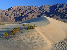
死亡谷(英語:Death Valley),為位於美國加州的沙漠谷地。屬於莫哈韦沙漠的一部分,亦為北美洲最低、最乾旱以及最熱的地區,死亡谷曾經擁有地球上最高氣溫的觀測紀錄56.7 °C(134.1 °F)[3],發生於1913年7月10日的弗尼斯克里克[4]。 死亡谷的惡水盆地為海平面下86米(282英尺),是北美最低點,與美國本土最高點、海拔4,421米(14,505英尺)的惠特尼峰相距84.6英里(136.2公里)[5],兩者都位於大盆地(Great Basin)的範圍內。
地理
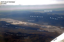
死亡谷位於加州與內華達州州界,東臨內華達山,死亡谷國家公園大部分地區皆屬其範疇。也是莫哈韋沙漠與科羅拉多沙漠生物圈保護區(Mojave and Colorado Deserts Biosphere Reserve)的主要部分。全境主要位於因約郡(Inyo)。
地質

死亡谷是盆地與山脈地形的的良好別,其位於Walker Lane地質槽最南端。 这座山谷被一条右移走滑移位断层截断成了死亡谷断层和火炉溪断层两个部分。山谷东端的左移卡洛克断层与死亡谷断层相交。火炉溪和阿马戈萨河从山谷中流过,并最终一同消失在了死亡谷的砂层里。 死亡谷內亦有鹽磐。據目前地質學上的共識,在更新世中期這一帶曾有內陸湖,稱為曼利湖(Lake Manly)。之後由於漸成沙漠,水份因而蒸發,留下豐富的蒸發鹽類,如常見的鈉鹽和硼砂。上述資源在1883年至1907年大量開採[6]。
氣候

死亡谷為亞熱帶沙漠氣候(柯本气候分类法: BWh),有著長又極端酷熱的夏季、暖冬以及少許降雨。一般而言,低海拔往往會有較高的溫度。當太陽加熱地面,熱辐射向上。但上升的空氣會因為周圍海拔,以及其上方的空氣的重量(大氣壓力)而困住。在較低海拔處,大氣壓力會高於海平面,這是由於大气层與地面距離更高的原因。儘管有陰影與其他因素,這種氣壓抑制地面上的熱,足以使熱空氣产生循環的氣流,而把熱量扩散至該地全境[7]。
這個過程在死亡谷特別重要,因為它提供了其特有的氣候與地理特征。死亡谷被群山環繞,其地表平坦且缺乏植被,大量的太陽辐射熱到達地表,再被土壤與岩石吸收。地表的空氣被加熱並上升,沿着陡峭的山脈,逐渐冷卻,再回落谷底,向山谷聚集。然後,該底层较冷的空氣由太陽再次加熱溫度上升,沿着山向上,使空氣呈现向上和向下的週期循环,類似的炫風烤箱的原理。
這種過熱的空氣形成了山谷中沿山脈的熱氣流,且大多囿于山谷內。這種熱氣流有利于持久的乾旱,並且讓雲不易停留在死亡谷的上空,而降水往往是由幡狀雲的形式[8]。因眾多因素,死亡谷創下最高氣溫的紀錄。

死亡谷的深度與形狀,影響了夏季溫度。死亡谷是長而窄的盆地,在海平面下86米(282英尺),四周有高聳陡峭的山脈。地表由乾空氣與稀疏的植被覆蓋,陽光可直接加熱沙漠表面。夜間則能下降至28至37 °C(82至99 °F)。大量熱空氣吹過山谷,創下很高的溫度[9]。
1913年7月10日在爐溪谷地(Furnace Creek)所觀測的56.7 °C(134.1 °F)[4],是當地最高觀測氣溫,同時也是地球目前最高觀測氣溫[4]。創紀錄的當時,連續5日的氣溫都在54 °C(129 °F)以上。死亡谷記錄的最高夜間低溫是43 °C(109 °F),而另一個最高夜間低溫紀錄是阿曼的42.6 °C(108.7 °F)。

死亡谷全年平均降水量為60毫米(2.4英寸),其中Greenland Ranch測站平均僅40毫米(1.6英寸)[10]。2023年8月20日,希拉里颶風侵襲死亡谷,降下2.2英吋的降雨量,為當地帶來一年的降雨量,也打破上次的單日降雨紀錄(2022年8月5日創下1.7英吋的降雨量)。[11]
觀測史中,最潮濕的月份出現於1995年1月,當時有66毫米(2.6英寸)的降雨[8]。最潮濕年度出現在2004年中至2005年中,當時計有50毫米(2.0英寸)的降雨,使得谷中出現間歇湖,出現大量野花盛開的景色[12]。死亡谷唯一的積雪紀錄,出現在1922年1月。
| 死亡谷(爐溪谷地測站)(1991–2020正常值,1911年至今极端数据) | |||||||||||||
|---|---|---|---|---|---|---|---|---|---|---|---|---|---|
| 月份 | 1月 | 2月 | 3月 | 4月 | 5月 | 6月 | 7月 | 8月 | 9月 | 10月 | 11月 | 12月 | 全年 |
| 历史最高温 °F(°C) | 90 (32) |
97 (36) |
103 (39) |
113 (45) |
122 (50) |
128 (53) |
134 (57) |
130 (54) |
125 (52) |
113 (45) |
98 (37) |
89 (32) |
134 (57) |
| 平均最高温 °F(°C) | 78.4 (25.8) |
85.1 (29.5) |
95.4 (35.2) |
106.0 (41.1) |
113.6 (45.3) |
122.0 (50.0) |
125.9 (52.2) |
123.4 (50.8) |
118.1 (47.8) |
106.2 (41.2) |
90.0 (32.2) |
77.8 (25.4) |
126.7 (52.6) |
| 平均高温 °F(°C) | 67.2 (19.6) |
73.7 (23.2) |
82.6 (28.1) |
91.0 (32.8) |
100.7 (38.2) |
111.1 (43.9) |
117.4 (47.4) |
115.9 (46.6) |
107.7 (42.1) |
93.3 (34.1) |
77.4 (25.2) |
65.6 (18.7) |
92.0 (33.3) |
| 日均气温 °F(°C) | 54.9 (12.7) |
61.3 (16.3) |
69.8 (21.0) |
77.9 (25.5) |
87.8 (31.0) |
97.5 (36.4) |
104.2 (40.1) |
102.3 (39.1) |
93.4 (34.1) |
78.9 (26.1) |
64.0 (17.8) |
53.4 (11.9) |
78.8 (26.0) |
| 平均低温 °F(°C) | 42.5 (5.8) |
49.0 (9.4) |
57.1 (13.9) |
64.8 (18.2) |
75.0 (23.9) |
84.0 (28.9) |
91.0 (32.8) |
88.7 (31.5) |
79.1 (26.2) |
64.4 (18.0) |
50.5 (10.3) |
41.1 (5.1) |
65.6 (18.7) |
| 平均最低温 °F(°C) | 30.5 (−0.8) |
36.1 (2.3) |
42.8 (6.0) |
49.8 (9.9) |
58.5 (14.7) |
67.9 (19.9) |
78.3 (25.7) |
75.3 (24.1) |
65.4 (18.6) |
49.5 (9.7) |
35.9 (2.2) |
29.0 (−1.7) |
28.0 (−2.2) |
| 历史最低温 °F(°C) | 15 (−9) |
20 (−7) |
26 (−3) |
35 (2) |
42 (6) |
49 (9) |
62 (17) |
65 (18) |
41 (5) |
32 (0) |
24 (−4) |
19 (−7) |
15 (−9) |
| 平均降水量 英寸(mm) | 0.37 (9.4) |
0.52 (13) |
0.25 (6.4) |
0.10 (2.5) |
0.03 (0.76) |
0.05 (1.3) |
0.10 (2.5) |
0.10 (2.5) |
0.20 (5.1) |
0.12 (3.0) |
0.10 (2.5) |
0.26 (6.6) |
2.2 (55.56) |
| 平均降水天数(≥ 0.01 in) | 2.4 | 2.9 | 2.0 | 1.1 | 0.9 | 0.3 | 1.1 | 0.9 | 0.8 | 1.1 | 0.9 | 1.6 | 16 |
| 月均日照時數 | 217 | 226 | 279 | 330 | 372 | 390 | 403 | 372 | 330 | 310 | 210 | 186 | 3,625 |
| 数据来源1:NOAA 1981–2010 US Climate Normals [13] | |||||||||||||
| 数据来源2:weather2travel | |||||||||||||
| 死亡谷(Cow Creek 測站) | |||||||||||||
|---|---|---|---|---|---|---|---|---|---|---|---|---|---|
| 月份 | 1月 | 2月 | 3月 | 4月 | 5月 | 6月 | 7月 | 8月 | 9月 | 10月 | 11月 | 12月 | 全年 |
| 历史最高温 °F(°C) | 84 (29) |
89 (32) |
100 (38) |
110 (43) |
120 (49) |
125 (52) |
126 (52) |
125 (52) |
123 (51) |
111 (44) |
95 (35) |
84 (29) |
126 (52) |
| 平均高温 °F(°C) | 64.4 (18.0) |
71.6 (22.0) |
80.6 (27.0) |
90.9 (32.7) |
100.0 (37.8) |
109.3 (42.9) |
116.0 (46.7) |
113.8 (45.4) |
106.9 (41.6) |
92.1 (33.4) |
75.4 (24.1) |
65.9 (18.8) |
90.6 (32.6) |
| 日均气温 °F(°C) | 52.5 (11.4) |
59.1 (15.1) |
67.4 (19.7) |
77.5 (25.3) |
86.4 (30.2) |
95.3 (35.2) |
102.1 (38.9) |
99.9 (37.7) |
92.1 (33.4) |
78.1 (25.6) |
62.3 (16.8) |
54.1 (12.3) |
77.2 (25.1) |
| 平均低温 °F(°C) | 40.6 (4.8) |
46.6 (8.1) |
54.3 (12.4) |
64.1 (17.8) |
72.7 (22.6) |
81.2 (27.3) |
88.4 (31.3) |
86.0 (30.0) |
77.4 (25.2) |
64.0 (17.8) |
49.3 (9.6) |
42.4 (5.8) |
63.9 (17.7) |
| 历史最低温 °F(°C) | 19 (−7) |
30 (−1) |
33 (1) |
45 (7) |
52 (11) |
54 (12) |
69 (21) |
69 (21) |
57 (14) |
40 (4) |
32 (0) |
27 (−3) |
19 (−7) |
| 平均降水量 英寸(mm) | 0.24 (6.1) |
0.32 (8.1) |
0.20 (5.1) |
0.20 (5.1) |
0.10 (2.5) |
0.02 (0.51) |
0.10 (2.5) |
0.11 (2.8) |
0.12 (3.0) |
0.11 (2.8) |
0.20 (5.1) |
0.29 (7.4) |
2.00 (51) |
| 数据来源:www | |||||||||||||
惡水湖與曼利湖


2005年時,死亡谷降雨為平均年雨量的4倍,使得百餘年前的湖泊再現。湖泊範圍既淺又遼闊,但極端的熱與乾旱很快就使其乾涸。
右圖為NASA的Landsat 5衛星,紀錄了惡水湖的短暫歷史。在2005年時,大規模綠色的水體佈滿谷地。但在同年5月前,谷地已恢復為往昔的惡水盆地(實為鹽灘)。隨著時間的推移,這種溶解與結晶的鹽會逐漸變黑。
死亡谷的西緣緊接著是沖積扇。在暴洪時期,降雨從陡峭的山上向西邊潑濺下來,通過狹窄的峽谷,帶走包括細黏土至大石頭的一切東西。當這些水流到達峽谷口時,變得寬大且緩慢而形成分支的辮狀河。沖積扇所呈現的顏色愈白,則其在地質上愈年輕。
在距今大約於1萬至1萬2千年前結束的第四紀冰河時期時,內華達山脈的氣候較為濕潤。而在此時死亡谷被一座稱為曼利湖的冰漬湖所填滿,其長度接近100英里,深度約600英尺。
歷史
死亡谷是美国联邦政府确认的提笔沙(Timbisha)美国印第安人的家园,他们在此至少居住了1000年。他们以前被叫做帕纳闽特· 休休尼族印第安人(Panamint Shoshone)。提笔沙的名称来自tümpisa,意思是红赭色岩画,这种颜料来自山谷中的赭色黏土。现在仍然有一些家庭居住在炉溪谷地。另一个村庄在葡藤山峡谷(Grapevine Canyon)的地方,那里靠近现在的司考提城堡(农庄)(Scotty's Castle)。葡藤山峡谷在提笔沙语(Timbisha language)中叫做麻乎努(maahunu),其中hunu是峡谷的意思。

在1849年的加利福尼亚淘金潮(California Gold Rush)期间,探矿者[16]给这里起了个英文名叫做死亡谷。但是在整个淘金潮期间,穿越死亡谷的淘金者中,只有一名死者的记录。 在1850年代,死亡谷开出金矿和银矿,1880代发现并开采硼砂,当时使用一种用二十匹骡马(mule-drawn wagons)拉的车运输出去。
1933年2月11日,时任赫伯特·胡佛总统宣布死亡谷为联邦政府保护区。1994年,保护区成为死亡谷国家公园,并扩大范围包括了萨林和尤里卡峡谷。
著名景點
相關
參考
- ^ USGS National Elevation Dataset (NED) 1 meter Downloadable Data Collection from The National Map 3D Elevation Program (3DEP) – National Geospatial Data Asset (NGDA) National Elevation Data Set (NED). United States Geological Survey. September 21, 2015 [September 22, 2015]. (原始内容存档于March 25, 2019).
- ^ Feature Detail Report for: Death Valley. Geographic Names Information System. United States Geological Survey.
- ^ World Meteorological Organization World Weather / Climate Extremes Archive. [10 January 2013]. (原始内容存档于2013年1月4日).
- ^ 4.0 4.1 4.2 El Fadli, KI; et al. World Meteorological Organization Assessment of the Purported World Record 58°C Temperature Extreme at El Azizia, Libya (13 September 1922). Bulletin of the American Meteorological Society. September 2012, 94 (2): 199 [2013-07-01]. doi:10.1175/BAMS-D-12-00093.1. (原始内容存档于2015-09-03). (The 136 °F (57.8 °C), claimed by 'Aziziya, Libya, on September 13, 1922, has been officially deemed invalid by the World Meteorological Organization.)
- ^ Find Distance and Azimuths Between 2 Sets of Coordinates. Federal Communications Commission. [2010-08-13]. (原始内容存档于2010-05-28).
- ^ Celeste Cosby; Jeanette Hawkins; Jani Kushla; Molly Robinson. Boron Minerals of Death Valley. Clark Science Center, Smith College. 2009. (原始内容存档于2008-03-17).
- ^ Weather and Climate Death Valley National Park (PDF). U.S. National Park Service. July 2007 [2009-04-16]. (原始内容存档 (PDF)于2009-03-27).
- ^ 8.0 8.1 Weather and Climate. Death Valley National Park. U.S. National Park Service. 23 May 2008 [2009-04-16]. (原始内容存档于2010-05-30).
- ^ National Park Service. Weather and Climate (PDF). Death Valley. NPS.gov. [2009-05-29]. (原始内容存档 (PDF)于2009-03-27).
- ^ WRCC. Monthly Climate Summary. Desert Research Institute. [2009-06-08]. (原始内容存档于2011-05-13).
- ^ Caitlin O'Kane. Death Valley, known for heat and drought, got about a year's worth of rain in a day from Hilary. CBS News. CBS Interactive Inc. 22 August 2023 [2023-08-24]. (原始内容存档于2023-08-27).
- ^ NPR.org. [2013-07-01]. (原始内容存档于2011-06-28).
- ^ NOAA. 1981–2010 US Climate Normals. NOAA. [2011-07-25]. (原始内容存档于2011-05-13).
- ^ Weather2travel.com. Weather2travel Death Valley Climate. [2011-06-161]. (原始内容存档于2018-01-30).
- ^ WRCC. Western U.S. Climate Historical Summaries Weather. Desert Research Institute. [2009-06-03]. (原始内容存档于2011-05-13).
- ^ Lingenfelter, Richard E.; Dwyer, Richard A. Death Valley Lore, Classic Tales of Fantasy, Adventure and Mystery. Reno: University of Nevada Press. 1988. ISBN 0-87417-136-9.
連結
 维基导游上有關Death Valley的旅行指南
- Fossils In Death Valley National Park
- National Park Service: Official Death Valley National Park website (页面存档备份,存于互联网档案馆)
- Death Valley (页面存档备份,存于互联网档案馆) on the PBS show Nature
- Historical photographs of Death Valley (1926) (页面存档备份,存于互联网档案馆), The Bancroft Library
- UNESCO Biosphere Preserve: Mojave and Colorado Deserts
- Strange moving rocks of the valley (页面存档备份,存于互联网档案馆)
- The Phenotypic Plasticity of Death Valley's Pupfishes (页面存档备份,存于互联网档案馆) an American Scientist article by Sean Lema
- Death Valley Area Interactive Map (页面存档备份,存于互联网档案馆)
- Death Valley Weather
- 美國地質調查局地名資訊系統:Death Valley
- Death Valley Nonprofit Support Organization (页面存档备份,存于互联网档案馆)
- Death Valley (页面存档备份,存于互联网档案馆) on National Geographic[1] (页面存档备份,存于互联网档案馆)
| ||||||||||||||||||||||||||||||
Text is available under the CC BY-SA 4.0 license; additional terms may apply.
Images, videos and audio are available under their respective licenses.


