普托拉納高原
| 世界遗产 | |
|---|---|
 普托拉納高原 | |
| 官方名稱 | Putorana Plateau(英文) Plateau de Putorana(法文) |
| 位置 | |
| 標準 | 自 (ix)(x) |
| 参考编码 | 1234rev |
| 登录年份 | 2010(第34屆會議) |
| 面积 | 1,887,251 ha(7,286.72 sq mi) |
| 網站 | UNESCO的记录(英文) |
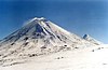
普托拉納高原是俄羅斯的玄武岩高原,位於泰梅爾半島以南中西伯利亞高原西北側的高山地區,最高點海拔高度1,700米,由西伯利亞暗色岩組成,這個地區有維維湖和大型鎳礦,鄰近城市有諾里爾斯克。
 |
 |
 | ||
| 地貌 | 位置 | 鳥瞰圖 |
外部連結
[编辑]- Official website of the Putorana Nature Reserve
- The Putorana Plateau (页面存档备份,存于互联网档案馆) Natural Heritage Protection Fund.
| ||||||||||||
| ||||||||||||||||||||||||||||||||||||||||||||||||


Text is available under the CC BY-SA 4.0 license; additional terms may apply.
Images, videos and audio are available under their respective licenses.
Cover photo is available under {{::mainImage.info.license.name || 'Unknown'}} license.
Cover photo is available under {{::mainImage.info.license.name || 'Unknown'}} license.
Credit:
(see original file).
