明古魯省
| 明古魯省 | |||
|---|---|---|---|
| 省 | |||
| |||
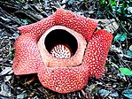
| 綽號:Bumi Rafflesia Land of Rafflesia | |||
| 格言:Sekundang setungguan seio sekato (马来语) (Many hands make light work.) | |||
 | |||
| 坐标:3°48′S 102°15′E / 3.8°S 102.25°E | |||
| 国家 | |||
| 建立 | 1968年11月18日 | ||
| 首都 | Bengkulu | ||
| 政府 | |||
| • Governor | Rohidin Mersyah | ||
| 面积 | |||
| • 总计 | 19,919.33 平方公里(7,690.90 平方英里) | ||
| 面积排名 | 24th | ||
| 人口(2017[1]) | |||
| • 總計 | 1,934,300人 | ||
| • 排名 | 26th | ||
| • 密度 | 97.1人/平方公里(252人/平方英里) | ||
| 居民称谓 | Bengkulunese Warga Bengkulu (id) | ||
| 人口 | |||
| • 族群 | Rejang (60,4%), 爪哇族 (22,3%), 明古魯語 (17,9%), Lembak (4,9%), Pasemah (4,4%), 米南佳保人 (4,3%), 马来族 (3,6%), 巽他族 (3%), 巴塔克人 (2%)[2] | ||
| • Religion | 伊斯兰教 95,27%, 基督教 3,59%, Hindu 0,73%, 佛教 0,41% | ||
| • Languages | Indonesian (official language), Rejangese, Javanese language, Serawai, Lembak language, etc. | ||
| 时区 | 印度尼西亚标准时间(UTC+7) | ||
| 邮政编码 | 38113-39374 | ||
| 電話區號 | 0732 (Kepahiang, Curup or Rejang Lebong), 0736 (Bengkulu, Central Bengkulu, Seluma), 0737 (Muko-Muko, North Bengkulu), 0738 (Lebong), 0739 (Kaur, South Bengkulu) | ||
| 車輛號牌 | BD | ||
| HDI | ▲ 0.693 (medium)[3] | ||
| HDI rank | 11th (2013)[4] | ||
| 網站 | bengkuluprov | ||
明古魯省(印尼文:Provinsi Bengkulu)是印尼在蘇門答臘島上的十個省份之一。省城為明古魯市。面積19,788.70平方公里。人口1,405,060(2000年統計數字。)
明古魯曾經是英國的殖民地,當時稱明古連(英文:Bencoolen)。于1824年的《英荷條約》簽訂後,英國將此地讓給荷蘭殖民。
地理
[编辑]地理位置
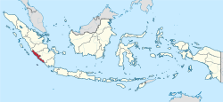
[编辑]明古魯省位于蘇門答臘島的西南方沿岸。領土包括Enggano島。
陸鄰
近海
歷史
[编辑]1685年,不列颠东印度公司于明古連地區設立黑胡椒貿易站與軍事要塞。
1714年英國在此建立城堡Fort Marlborough。 此堡仍聳立于當地。
明古連的貿易發展並不理想,這是因為:
- 其地理位置非處于交通要道上,商人認為到此貿易不方便。
- 此地出產的黑胡椒數量不足,商人常買不到貨。
儘管困難重重,英國還是繼續經營明古連一直到1824年簽定《英荷條約》後,于1825年3月1日交給荷蘭。荷蘭經營明古魯地區一直到第二次世界大戰發生[5],1941年12月7日太平洋戰爭爆發,二戰期間,日本曾經佔領此地一直到1945年8月15日日本裕仁天皇宣佈投降。
二戰後荷蘭意圖回到當地繼續進行殖民統治,但遭到當地民眾的反抗,1945年8月17日印尼宣佈獨立,1949年12月27日荷蘭完全由印尼撤軍。而早在1930年,印度尼西亚民族独立运动的领袖蘇卡諾曾經在明古魯地區生活多年,在這裡他遇見了其妻子Fatmawati,後來他倆的一位女兒成為印尼第五任總統,也是印尼第一位女總統梅加瓦蒂·苏加诺普翠。
經濟
[编辑]明古魯省在印尼屬于比較貧窮的省份。因此當地民眾非常熱衷于成為公務員。
煤礦業是當地經濟的主要支柱。當地三個主要煤礦公司每年生產了200,000到400,000吨的煤。明古魯的煤主要出口到馬來西亞、新加坡、南亞及東北亞。
當地漁業也很發達,出名的漁獲有鮪魚及鯖魚等。農業方面,有薑、筍、橡膠等作物。
参考
[编辑]- ^ Statistik Indonesia 2018. Badan Pusat Statistik. [July 23, 2018]. (原始内容存档于2018-11-20).
- ^ Bengkulu Lumbung Nasionalis yang Cair. epaper.kompas.com. February 11, 2009.
- ^ Indeks Pembangunan Manusia Metode Baru 2010–2014. [13 March 2016]. (原始内容存档于2017-11-20).
- ^ Indeks Pembangunan Manusia Menurut Provinsi, 1996–2013. [5 May 2016]. (原始内容存档于2019-04-16).
- ^ Roberts, Edmund. Embassy to the Eastern Courts of Cochin-China, Siam, and Muscat. New York: Harper & Brothers. 1837: 34 [2013-10-14]. (原始内容存档于2013-10-14).
| |||||||||||||||||||||||||||||||||||||||
Text is available under the CC BY-SA 4.0 license; additional terms may apply.
Images, videos and audio are available under their respective licenses.


