揚馬延
| 揚馬延 | |
|---|---|
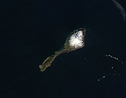
 NASA衛星圖像中的揚馬延島,貝倫火山則被雪覆蓋 | |
 揚馬延的位置(深綠色) | |
| 地理 | |
 揚馬延的位置(深綠色) | |
| 位置 | 北冰洋 |
| 坐标 | 70°59′N 8°32′W / 70.983°N 8.533°W |
| 面積 | 377平方公里(146平方英里) |
| 海岸線 | 124,100米(407200英尺) |
| 最高海拔 | 2,277米(7470英尺) |
| 最高點 | 貝倫火山 |
| 管轄 | |
| 郡 | 諾爾蘭郡 |
| 最大聚居地 | 奥隆金比恩(人口18) |
| 人口统计 | |
| 人口 | 18 |
扬马延(挪威語:Jan Mayen,東部城市挪威語:[jɑn ˈmɑ̀ɪən])[1]是一個位于北冰洋的火山島嶼,是挪威的领土。島長約55 km(34 mi),面积约 377 km2(146 sq mi),貝倫火山附近約114.2 km(71.0 mi)被冰川所覆蓋,約佔島上約1/3的面積。气候恶劣,寒冷多雾。
自然資源
揚馬延島擁有一種可開採的自然資源礫石。
揚馬延島有重要的漁業資源,島周圍建立了一個大型專屬經濟區。挪威和丹麥之間關於揚馬延島和格陵蘭島之間的捕魚禁區的爭端於 1988 年得到解決,丹麥獲得更大的主權區域。地質學家懷疑在揚馬延島周圍的海底下方蘊藏著大量的石油和天然氣。
社會
人口統計
島上唯一的居民是為挪威武裝部隊和挪威氣象研究所工作的人員。島上有 18 人過冬,但在夏季進行大量維護時,人口可能會大約翻倍 (35人)。島上人員服務六個月或一年,每年四月和十月交換兩次。支援人員,包括機械師、廚師和護士,都在軍事人員之列。LORAN 發射機和氣象站都位於距定居點幾公里的地方奧隆金比恩。
運輸
由屬於挪威皇家空軍的C-130運輸機提供前往該島的運輸服務,該飛機降落在Jan Mayensfield的碎石跑道上。這些飛機每年從博德主航空站起飛八次。由於機場沒有任何儀表著陸功能,因此需要良好的能見度,飛機不得不返回兩小時外的博德而沒有著陸的情況並不少見。
歷史
從 1615 年到 1638 年,揚馬延被荷蘭Noordsche Compagnie公司用作捕鯨基地,該公司於 1614 年被國會授予北極地區的捕鯨壟斷權。
在1882-1883 年國際極地年期間,奧匈帝國北極探險隊在揚馬延島停留了一年。探險隊對該地區進行了廣泛的測繪,他們的地圖品質之高,一直使用到 1950 年代。
北極熊出現在揚馬延島,儘管與早期相比數量有所減少。1900 年至 1920 年間,有許多挪威捕獵者在揚馬延島過冬,除北極熊外,還獵殺北極狐。但因利潤下降,狩獵活動很快結束。北極這一地區的北極熊與生活在其他地方的北極熊在基因上是有區別的。
國際聯盟授予挪威對該島的管轄權,並於 1921 年開設了第一個氣象站。挪威氣象研究所於1922年兼併了該島的中部,1926年由Hallvard Devold擔任該島氣象觀測基地負責人時兼併了整個島嶼。1930 年 2 月 27 日,該島在法律上成為挪威王國的一部分。
環境
自然保護區
2010 年頒布的一項規定將該島列為挪威管轄下的自然保護區。該條例的目的是確保保護一個原始的北極島嶼和附近的海洋生物,包括海底。由於島上沒有商業航空公司運營,除非包機,否則無法乘飛機到達。且必須事先獲得包機降落的許可。必須提前獲得上島許可,一般限制在幾天(甚至幾小時)以內。禁止搭帳篷或紮營。外國人的逗留有單獨的規定。
氣候
| 揚馬延(1991–2020正常值,1921年至今极端数据) | |||||||||||||
|---|---|---|---|---|---|---|---|---|---|---|---|---|---|
| 月份 | 1月 | 2月 | 3月 | 4月 | 5月 | 6月 | 7月 | 8月 | 9月 | 10月 | 11月 | 12月 | 全年 |
| 历史最高温 °C(°F) | 9.5 (49.1) |
10.0 (50.0) |
8.0 (46.4) |
10.3 (50.5) |
14.3 (57.7) |
18.1 (64.6) |
18.0 (64.4) |
17.0 (62.6) |
14.2 (57.6) |
15.0 (59.0) |
10.0 (50.0) |
12.3 (54.1) |
18.1 (64.6) |
| 平均最高温 °C(°F) | 4.6 (40.3) |
3.6 (38.5) |
3.7 (38.7) |
4.9 (40.8) |
7.0 (44.6) |
9.5 (49.1) |
11.9 (53.4) |
11.0 (51.8) |
9.9 (49.8) |
7.7 (45.9) |
5.2 (41.4) |
5.2 (41.4) |
12.9 (55.2) |
| 平均高温 °C(°F) | −0.9 (30.4) |
−1.5 (29.3) |
−1.9 (28.6) |
−0.5 (31.1) |
1.9 (35.4) |
4.9 (40.8) |
7.4 (45.3) |
7.8 (46.0) |
5.9 (42.6) |
2.9 (37.2) |
0.7 (33.3) |
−0.6 (30.9) |
2.2 (35.9) |
| 日均气温 °C(°F) | −2.9 (26.8) |
−3.4 (25.9) |
−3.8 (25.2) |
−2.2 (28.0) |
0.4 (32.7) |
3.3 (37.9) |
5.8 (42.4) |
6.4 (43.5) |
4.6 (40.3) |
1.4 (34.5) |
−1.0 (30.2) |
−2.5 (27.5) |
0.5 (32.9) |
| 平均低温 °C(°F) | −4.9 (23.2) |
−5.4 (22.3) |
−5.6 (21.9) |
−3.9 (25.0) |
−1.1 (30.0) |
1.6 (34.9) |
4.3 (39.7) |
5.0 (41.0) |
3.2 (37.8) |
−0.1 (31.8) |
−2.6 (27.3) |
−4.4 (24.1) |
−1.2 (29.9) |
| 平均最低温 °C(°F) | −12.5 (9.5) |
−12.4 (9.7) |
−12.8 (9.0) |
−10.4 (13.3) |
−5.4 (22.3) |
−1.3 (29.7) |
1.5 (34.7) |
2.0 (35.6) |
−1.0 (30.2) |
−5.6 (21.9) |
−8.8 (16.2) |
−12.1 (10.2) |
−15.1 (4.8) |
| 历史最低温 °C(°F) | −26.9 (−16.4) |
−28.4 (−19.1) |
−26.8 (−16.2) |
−21.4 (−6.5) |
−12.0 (10.4) |
−5.1 (22.8) |
−3.2 (26.2) |
−2.3 (27.9) |
−5.2 (22.6) |
−18.0 (−0.4) |
−19.5 (−3.1) |
−24.2 (−11.6) |
−28.4 (−19.1) |
| 平均降水量 mm(英寸) | 76.2 (3.00) |
63.4 (2.50) |
66.7 (2.63) |
48.2 (1.90) |
49.8 (1.96) |
29.6 (1.17) |
43.0 (1.69) |
70.4 (2.77) |
93.9 (3.70) |
85.3 (3.36) |
81.4 (3.20) |
82.2 (3.24) |
790.1 (31.11) |
| 平均降水天数(≥ 1 mm) | 13 | 11 | 12 | 9 | 8 | 8 | 8 | 11 | 13 | 15 | 13 | 13 | 134 |
| 平均相對濕度(%) | 83 | 83 | 84 | 83 | 85 | 87 | 89 | 87 | 83 | 83 | 81 | 82 | 84 |
| 月均日照時數 | 0 | 28 | 62 | 120 | 155 | 150 | 124 | 93 | 60 | 31 | 0 | 0 | 823 |
| 数据来源1:Worldwide Bioclimatic Classification System[2] Meteo Climat | |||||||||||||
| 数据来源2:The Weather Network (humidity and precipitation days),[3] World Climate data (sunshine hours)[4] | |||||||||||||
參見
参考文献
引用
- ^ Berulfsen, Bjarne. Norsk Uttaleordbok. Oslo: H. Aschehoug & Co (W Nygaard). 1969: 157 (挪威语).
- ^ NORWAY - JAN MAYEN. [5 December 2011]. (原始内容存档于2019-05-02). Java plugin required
- ^ Statistics: Jan Mayen, Norway. The Weather Network. [2012-07-11].
- ^ Jan Mayen Climate Guide. [2012-07-11]. (原始内容存档于2016-03-16).
来源
- 书籍
- Umbreit, Andreas (2005) Spitsbergen : Svalbard - Franz Josef Land - Jan Mayen, 3rd ed., Chalfont St. Peter : Bradt Travel Guides, ISBN 1-84162-092-0
外部連結
- 《世界概况》上有关Jan Mayen的条目
- 开放目录项目中的“揚馬延”
 維基媒體的Jan Mayen地圖集
 维基导游上有關揚馬延的旅行指南
- www.jan-mayen.no
- Jan Mayen year round webcam
- Jan Mayen at Norwegian Polar Institute
- TopoJanMayen (页面存档备份,存于互联网档案馆) – Interactive map of Jan Mayen by the Norwegian Polar Institute
- Photographs and information on Jan Mayen
- Satellite Radar image of Jan Mayen
- Glaciers of Jan Mayen (页面存档备份,存于互联网档案馆)
- www.janmayen2011.org - a site about JX5O - international ham radio expedition to Jan Mayen island in 2011
- Structurae数据库中LORAN-C Transmission Mast (Jan Mayen)的数据
- Weather forecasts for Jan Mayen at yr.no (Norwegian Meteorological institute and NR
| |||||||||||||||||||||||||||||||||||||||||||||||
| ||||||||||||||||||||||||||||||||||||||||||||||||||||||||||||||||||||||||||||||||||||||||||
| ||||||||||||||||||||||||
| ||||||||||||||||||||||
Text is available under the CC BY-SA 4.0 license; additional terms may apply.
Images, videos and audio are available under their respective licenses.


