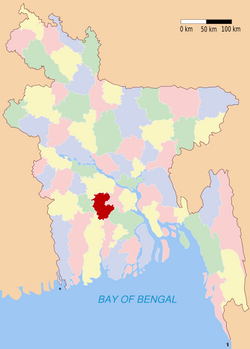
戈巴尔甘杰县
| 戈巴尔甘杰县 গোপালগঞ্জ জেলা | |
|---|---|
| 縣 | |
 戈巴尔甘杰县於孟加拉位置圖 | |
| 坐标:23°12′N 89°48′E / 23.2°N 89.8°E | |
| 國家 | |
| 專區 | 達卡專區 |
| 面积 | |
| • 总计 | 1,489.92 平方公里(575.26 平方英里) |
| 人口(1991) | |
| • 總計 | 1,132,046人 |
| • 密度 | 760人/平方公里(1,968人/平方英里) |
| 識字率 | |
| • 總計 | 38.2% |
| 时区 | BST(UTC+6) |
| • 夏时制 | BDST(UTC+7) |
| 網站 | Banglapedia Article |

戈巴尔甘杰县[1](Gopalganj District)为孟加拉国达卡专区辖县,属孟加拉国中南部县份。县境北与福里德布尔县接壤,东与马达里布尔、巴里萨尔县毗邻,南与比罗杰布尔县交界,西与巴盖尔哈德、诺拉尔县相连。全境年平均温度12.6°C至35.8°C,年平均降雨量2,105毫米。县域总面积1,489.92公里²,总人口1,132,046人(1991)。全县共分置5乡(乌帕齐拉),政府驻戈巴尔甘尼市。
参考
[编辑]引用
[编辑]- ^ 世界地名译名词典 2017,第971頁.
来源
[编辑]- 民政部地名研究所 (编). Gopālganj 戈巴尔甘杰. 世界地名译名词典. 北京: 中国社会出版社. 2017-05. ISBN 978-7-5087-5525-0. OCLC 1121629943. OL 28272719M. NLC 009152391.(简体中文)
- 孟加拉国百科(英文版):戈巴尔甘杰县(Gopalganj District)
- 地名译名参考行政区划网:世界政区(亚洲)/孟加拉国 (页面存档备份,存于互联网档案馆)
| |||||||||||||||||||||||||||||||||||||||||||||||||||||||||||
| |||||||||
Text is available under the CC BY-SA 4.0 license; additional terms may apply.
Images, videos and audio are available under their respective licenses.

