For faster navigation, this Iframe is preloading the Wikiwand page for 艾瑟爾湖.

艾瑟爾湖

艾瑟尔湖
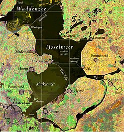
艾瑟尔湖的衛星地圖
位置荷蘭北部
坐标52°49′N 5°15′E / 52.817°N 5.250°E / 52.817; 5.250
湖泊类型人工湖
主要流入艾瑟爾河
主要流出瓦登海
所在国家荷蘭
表面积1,100 平方公里
平均深度5.5 米
最大深度7米
表面海拔-0.4至-0.2米
岛屿De Kreupel
地图
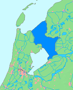
地圖中藍色的區域即為艾瑟爾湖

艾瑟尔湖[1]荷蘭語IJsselmeer;德語:Eisselmeer、Ysselmeer)是荷蘭中央的一個淺的淡水湖,面積為1100km²,平均深度為5-6米。艾瑟尔湖是須德海在1933年被阿夫鲁戴克大堤(Afsluitdijk)所隔開後,所形成的人工湖。

斯塔福伦一侧的火车轮渡渡口

在1886年至1936年间,湖上有铁路轮渡荷兰语Veerdienst Enkhuizen - Stavoren,载着鐵路貨車来往湖西岸的恩克赫伊曾和东岸的斯塔福伦

參見

[编辑]

参考文献

[编辑]
  1. ^ 民政部地名研究所 (编). IJsselmeer 艾瑟尔湖 [荷]. 世界地名译名词典. 北京: 中国社会出版社. 2017-05. ISBN 978-7-5087-5525-0. OCLC 1121629943. OL 28272719M. NLC 009152391. (简体中文)
{{bottomLinkPreText}} {{bottomLinkText}}
艾瑟爾湖
Listen to this article

This browser is not supported by Wikiwand :(
Wikiwand requires a browser with modern capabilities in order to provide you with the best reading experience.
Please download and use one of the following browsers:

This article was just edited, click to reload
This article has been deleted on Wikipedia (Why?)

Back to homepage

Please click Add in the dialog above
Please click Allow in the top-left corner,
then click Install Now in the dialog
Please click Open in the download dialog,
then click Install
Please click the "Downloads" icon in the Safari toolbar, open the first download in the list,
then click Install
{{::$root.activation.text}}

Install Wikiwand

Install on Chrome Install on Firefox
Don't forget to rate us

Tell your friends about Wikiwand!

Gmail Facebook Twitter Link

Enjoying Wikiwand?

Tell your friends and spread the love:
Share on Gmail Share on Facebook Share on Twitter Share on Buffer

Our magic isn't perfect

You can help our automatic cover photo selection by reporting an unsuitable photo.

This photo is visually disturbing This photo is not a good choice

Thank you for helping!


Your input will affect cover photo selection, along with input from other users.

X

Get ready for Wikiwand 2.0 🎉! the new version arrives on September 1st! Don't want to wait?