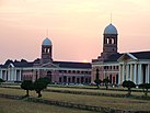
台拉登
| 台拉登 Dehradun / Dera Doon | |
|---|---|
| 綽號:Doon | |
| 坐标:30°19′05″N 78°01′44″E / 30.318°N 78.029°E | |
| 國家 | 印度 |
| 邦 | 北阿坎德邦 |
| 縣 | 台拉登 |
| 創立 | 1676 |
| 都會 | 1867 |
| 政府 | |
| • 类型 | 市长-议会 |
| • 行政机构 | Dehradun Municipal Corporation |
| • 市长 | Sunil Uniyal 'Gama'(BJP) |
| • 市政专员 | Vinay Shankar Pandey,[1]印度行政服务团 |
| 面积[2][3] | |
| • 市 | 196.48 平方公里(75.86 平方英里) |
| • 都會區 | 300 平方公里(100 平方英里) |
| 海拔 | 636 公尺(2,087 英尺) |
| 人口(2018)[2][4][5] | |
| • 市 | 803,983人 |
| • 密度 | 4,092人/平方公里(10,598人/平方英里) |
| • 都會區(2001)[6] | 1,279,083 |
| 語言 | |
| • 官方 | 印地语[7] |
| • 其他 | 梵语[8][9] |
| • 區域 | 加尔瓦里语、Jaunsari |
| 时区 | IST(UTC+5:30) |
| 邮政编码 | 248001 |
| 電話區號 | +91-135 |
| 車輛號牌 | UK-07 |
| 網站 | dehradun |
台拉登[10](印地语:देहरादून;拉丁化:Dehradun、Dehra Doon),或译德拉敦、德赫拉敦,为印度北阿坎德邦(旧称北安查尔邦)首府,也是台拉登县行政中心和北阿坎德邦最大城市,南面距首都德里270公里。在印度,台拉登因其高收入而闻名。地理上,该城市地处印度河-恒河平原北缘,北枕喜马拉雅山脉,南依西瓦利克山脉,东临恒河,西接亚穆纳河,为二河分水岭所处位置。
参考资料
- ^ Jha, Prashant. DMC to start registration of cattle in Dehradun | Dehradun News - Times of India. The Times of India. 12 May 2019 [9 October 2019]. (原始内容存档于2019-11-03) (英语).
- ^ 2.0 2.1 About Nagar Nigam Dehradun. [2020-11-20]. (原始内容存档于2020-11-06).
- ^ Census of India - Uttarakhand - Town Amenities (Row 27, Column 24) (PDF). Census of India: 391. [20 October 2020]. (原始内容存档 (PDF)于2020-11-17).
- ^ Provisional Population Totals, Census of India 2011; Cities having population 1 lakh and above (PDF). Office of the Registrar General & Census Commissioner, India. [26 March 2012]. (原始内容存档 (PDF)于2012-05-07).
- ^ Provisional Population Totals, Census of India 2011; Urban Agglomerations/Cities having population 1 lakh and above (PDF). Office of the Registrar General & Census Commissioner, India. [26 March 2012]. (原始内容存档 (PDF)于2013-04-02).
- ^ Dehradun. [19 November 2020]. (原始内容存档于2020-12-02).
- ^ 52nd REPORT OF THE COMMISSIONER FOR LINGUISTIC MINORITIES IN INDIA (PDF). nclm.nic.in. Ministry of Minority Affairs: 47. [16 January 2019]. (原始内容 (PDF)存档于2017-05-25).
- ^ Sanskrit is second official language in Uttarakhand. Hindustan Times. 19 January 2010 [28 January 2020]. (原始内容存档于2019-06-27) (英语).
- ^ Sanskrit second official language of Uttarakhand. The Hindu. 21 January 2010 [28 January 2020]. (原始内容存档于2018-03-03) (英语).
- ^ 民政部地名研究所 (编). Dehra Dūn 台拉登. 世界地名译名词典. 北京: 中国社会出版社: 678. 2017-05. ISBN 978-7-5087-5525-0. OCLC 1121629943. OL 28272719M. NLC 009152391.(简体中文)
| ||||||||||||
Text is available under the CC BY-SA 4.0 license; additional terms may apply.
Images, videos and audio are available under their respective licenses.


