尤里卡縣
| 尤里卡縣 Eureka County | |
|---|---|
| 县 | |
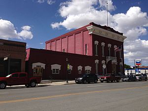
 尤里卡縣行政中心 | |
 尤里卡縣于内华达州中的位置 | |
 内华达州于美国的位置 | |
| 坐标:39°59′N 116°16′W / 39.98°N 116.27°W | |
| 国家 | |
| 州 | |
| 设立日期 | 1873年 |
| 語源 | 尤里卡 |
| 县治 | 尤里卡 |
| 最大城市 | 尤里卡 |
| 面积 | |
| • 总计 | 4,180 平方英里(10,000 平方公里) |
| • 陸地 | 4,176 平方英里(10,000 平方公里) |
| • 水域 | 4.3 平方英里(10 平方公里) 0.1% |
| 人口(2020年) | |
| • 總計 | 1,855人 |
| • 密度 | 0.44人/平方英里(0.17人/平方公里) |
| 时区 | 太平洋时区(UTC−8) |
| • 夏时制 | 太平洋时区(UTC−7) |
| 包含的国会选区 | 第2選區 |
| 網站 | co |
尤里卡縣(英語:Eureka County)是美国内华达州中部的一個縣,面積10,826平方公里。根據2020年美國人口普查,本縣共有人口1,855人。[1]本縣縣治為尤里卡(Eureka)。[2]
地理


根據2000年人口普查,尤里卡縣的總面積為4,180平方英里(10,800平方公里),其中有4,176平方英里(10,820平方公里),即99.9%為陸地;4平方英里(10平方公里),即0.1%為水域。[4]本縣既是內華達州面積第11大的縣份,亦是美國面積第100大的縣份。
毗鄰縣
尤里卡縣的所有毗鄰縣皆為內華達州的縣份。
國家保護區
- 洪堡-托伊亚比国家森林(部分)
人口
| 歷史人口數 | |||
|---|---|---|---|
| 調查年 | 人口 | %± | |
| 1880年 | 7,086 | — | |
| 1890年 | 3,275 | −53.8% | |
| 1900年 | 1,954 | −40.3% | |
| 1910年 | 1,830 | −6.3% | |
| 1920年 | 1,350 | −26.2% | |
| 1930年 | 1,333 | −1.3% | |
| 1940年 | 1,361 | 2.1% | |
| 1950年 | 896 | −34.2% | |
| 1960年 | 767 | −14.4% | |
| 1970年 | 948 | 23.6% | |
| 1980年 | 1,198 | 26.4% | |
| 1990年 | 1,547 | 29.1% | |
| 2000年 | 1,651 | 6.7% | |
| 2010年 | 1,987 | 20.4% | |
| [5][6][7] | |||
根據2000年人口普查[8],尤里卡縣擁有1,651居民、666住戶和440家庭。[9]其人口密度為每平方英里0.39居民(每平方公里0.15居民)。[10]本縣擁有1,025間房屋单位,其密度為每平方英里0.25間(每平方公里0.09間)。[11]
在666住户中,有33%擁有一個或以上的兒童(18歲以下)、56.5%為夫妻、5%為單親家庭、33.9%為非家庭、29.1%為獨居、9.9%住戶有同居長者。平均每戶有2.47人,而平均每個家庭則有3.08人。在1,651居民中,有27.8%為18歲以下、5.2%為18至24歲、28.6%為25至44歲、25.9%為45至64歲以及12.4%為65歲以上。人口的年齡中位數為38歲,女子對男子的性別比為100:106.6。成年人的性別比則為100:113.2。[12]
本縣的住戶收入中位數為$41,417,而家庭收入中位數則為$49,438。男性的收入中位數為$45,167,而女性的收入中位數則為$25,000,人均收入為$18,629。約12.6%家庭和8.9%人口在貧窮線以下,包括11.7%兒童(18歲以下)及16.4%長者(65歲以上)。[12]
參考文獻
- ^ quickfacts census. [2013-07-10]. (原始内容存档于2011-06-06).
- ^ Find a County. National Association of Counties. [2011-06-07].
- ^ US Board on Geographic Names. United States Geological Survey. 2007-10-25 [2008-01-31].
- ^ Census 2000 U.S. Gazetteer Files: Counties. United States Census. [2011-02-13]. (原始内容存档于2012-06-06).
- ^ 1900-1990 census data. United States Census Bureau. [2013-05-06]. (原始内容存档于2013-06-18).
- ^ American FactFinder. Factfinder2.census.gov. [2013-02-16]. (原始内容存档于2013-09-11).
- ^ University of Virginia Library. Mapserver.lib.virginia.edu. [2013-02-16]. (原始内容存档于2012-08-11).
- ^ American FactFinder. United States Census Bureau. [2008-01-31].
- ^ (英文)Population Profile of the United States: 2000 (页面存档备份,存于互联网档案馆)
- ^ Statistical profile of Alger County, Michigan 互联网档案馆的存檔,存档日期2012-04-07., United States Census Bureau, Census 2000
- ^ (英文)State and County QuickFacts 互联网档案馆的存檔,存档日期2004-04-01.
- ^ 12.0 12.1 (英文)American FactFinder (页面存档备份,存于互联网档案馆)
| |||||||||||||||||||||||||||||||||||
Text is available under the CC BY-SA 4.0 license; additional terms may apply.
Images, videos and audio are available under their respective licenses.

