多格蘭

多格蘭(英語:Doggerland)是一片現淹没在北海南部,曾經連接英國与歐洲大陸的土地。多格蘭曾從現今的英國東海岸延伸到荷蘭、德國西海岸和日德蘭半島,在中石器時期,是人類居住的棲息地。[1]直至公元前6500年至5000年,才因海平面上升而被逐漸淹没。[2]
形成

直到中新世中期,英国仍是歐洲的一个半島,由横跨多佛海峡的韋雅背斜相連。在約450,000年前的英吉利冰河時期,一塊冰蓋覆蓋了北海大部分地區,南部有一個大型的冰川湖,由萊茵河,斯海爾德河和泰晤士河河系提供水源。[3]
在大约18,000年前结束的末次冰盛期,北海和大部分不列颠群島被冰川冰覆蓋,海平面較今天低約120米(390英尺)。其後氣候變暖,在公元前12,000年左右的冰川末期,英國以及北海和英吉利海峽的大部分地區變成低洼的苔原。[4]
發展

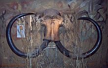
約公元前10,000年,北面的多格蘭沿海有潟湖、鹽沼、泥灘、海灘,而內陸則有河流、沼澤和湖泊。多格蘭的生態豐富多樣,比如,在北海的漁民曾在打撈的過程中尋獲真猛獁象頭骨。在中石器时代,它是歐洲人類重要的狩獵和捕撈場所,對了解歐洲人類的早期發展與遷徙起到了關鍵的影響。[5]
該地區的考古潛力在20世紀初首次被發現,1931年,當一艘在沃什河以東作業的拖網漁船拖上了一個帶倒鉤的鹿角點時,人們對該地區的考古潛力產生了濃厚的興趣,該點後來被確定為該地區還是苔原的時候。此後,船隻拖上了猛獁象、獅子和其他動物的遺骸,以及一些史前工具和武器。
截至2020年,國際團隊將繼續使用新的和傳統的考古地球物理技術、計算機模擬和分子生物學對多格蘭島的水下景觀進行為期兩年的調查。收集的證據允許研究過去的環境、生態變化以及人類從狩獵採集者到農業社區的轉變[6]。
淹沒
隨著冰河時期的最後一個冰川期結束,大量冰融化,海平面上升,由於大量冰流失,陸地以等静壓方式傾斜。多格蘭最終被淹没。公元前6500年,英倫三島開始與歐洲大陸隔絕。[4][7]多格蘭剩下的高地地區成為一個名為多格滩的島嶼。直至公元前5000年左右,多格灘也被淹沒。[8]

參見
參考文獻
- ^ Patterson, W, "Coastal Catastrophe" (paleoclimate research document), University of Saskatchewan (PDF). [2020-12-07]. (原始内容存档 (PDF)于2008-04-09).
- ^ "The Doggerland Project", University of Exeter Department of Archaeology. [2020-12-07]. (原始内容存档于2020-06-06).
- ^ Pettitt, Paul; White, Mark. The British Palaeolithic: Human Societies at the Edge of the Pleistocene World. Abingdon, UK: Routledge. 2012: 98–102, 277. ISBN 978-0-415-67455-3.
- ^ 4.0 4.1 University of Sussex, School of Life Sciences (页面存档备份,存于互联网档案馆), C1119 Modern human evolution, Lecture 6, slide 23
- ^ Vincent Gaffney, "Global Warming and Lost Lands: Understanding the Effects of Sea Level Rise". [2020-12-07]. (原始内容存档于2021-02-24).
- ^ The first archaeological artefacts found during the search for lost prehistoric settlements in the North Sea. University of Bradford. [2021-02-09]. (原始内容存档于2022-10-25) (英语).
- ^ Scarre, Chris. The Human Past: World Prehistory & the Development of Human Societies. London: Thames & Hudson. 2005: 180. ISBN 978-0-500-28531-2.
- ^ Bernhard Weninger et al., The catastrophic final flooding of Doggerland by the Storegga Slide tsunami, Documenta Praehistorica XXXV, 2008 (PDF). [2020-12-07]. (原始内容 (PDF)存档于2014-11-01).
- ^ Stride, A.H. On the origin of the Dogger Bank, in the North Sea. Geological Magazine. January 1959, 96 (1): 33–34 [12 January 2010]. doi:10.1017/S0016756800059197. (原始内容存档于2010-10-21).
Text is available under the CC BY-SA 4.0 license; additional terms may apply.
Images, videos and audio are available under their respective licenses.
