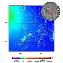
塔耳塔罗斯山脉
  塔耳塔罗斯山脉 | |
| 位置 | 位于俄耳枯斯火山口和埃律西昂火山区之间 |
|---|---|
| 坐标 | 15°28′N 167°32′E / 15.46°N 167.54°E |
塔耳塔罗斯山脉(Tartarus Montes)是火星埃律西昂区一道绵延1070多公里, 横亘于俄耳枯斯火山口和埃律西昂火山区之间的山脉[1],中心坐标位于北纬15.46度、东经167.54度附近[2]。
反照率最初是根据欧仁·安东尼亚第拍摄的明暗信号对比来确定的。
命名
[编辑]这山脉于1985年命名,根据火星地貌标准行星体系命名法[2],它取名自古希腊神话的地狱塔耳塔罗斯,根据希腊神话,塔耳塔罗斯是冥界最底层,宙斯将泰坦囚禁在塔耳塔罗斯;而该名字的第二部分“蒙特斯”(Montes)则是指“山脉”[3]。
特征
[编辑]由火星全球探勘者号拍摄的照片显示,塔耳塔罗斯山脉附近有圆锥体和火山环[4],周边区域地表则存在狭窄的地堑和裂缝,丘陵区及中间平原都显示有相似的标记,这意味着大量分布着与科柏洛斯槽沟有关的张性断裂带。格廖特谷是一条溢出河道,曾一度穿越了塔耳塔罗斯山脉的基岩脊[5]。
这道山脉无疑是由因风雨活动而上升到地表的火山物质构成,因此,该地区是地下水释放和随火山活动产生的大体平行的狭长裂缝所构成[6]。
塔耳塔罗斯山脉与佛勒格拉山脉一起构成一道复杂孤立的山脊和丘陵系统,显示了火山上大规模气候和地貌变化的概况[7]。

该地区可追溯至很久前有利于水或冰存在的诺亚纪开始到赫斯珀里亚纪开始时期,即大约35至41亿年前[8]。 因此,塔耳塔罗斯山脉区较形成于约32亿年前亚马逊纪的埃律西昂高原区更古老,从该地区的陨石坑数量也可看出,那里陨坑数要多得多[8]。

从冷却熔岩中渗出的大量液态水,流入塔耳塔罗斯山脉地区,这可能解释了该位置的部分火山物质[9]。
大量的流水也会流入阿耳枯斯火山口的北侧坡,从破裂熔岩中渗出的大量液态水,其中一些可能漫过了阿耳枯斯火山口的北侧坡[9]。
因此,推测该山脉可能因蒸汽爆炸而形成了密布的火山口。
另请查看
[编辑]参考文献
[编辑]- ^ PIA10800: Tartarus Montes. Nasa. [31 August 2012]. (原始内容存档于2021-04-22).
- ^ 2.0 2.1 "塔耳塔罗斯山脉". Gazetteer of Planetary Nomenclature. USGS Astrogeology Research Program.
- ^ NASA Mars Odyssey THEMIS Image: The Naming of Things: Tartarus Montes. Mars Today. [31 August 2012]. (原始内容存档于2013-01-28).
- ^ Ring/Cone Structures in the Tartarus Montes/Phlegra Dorsa Region. hirise.lpl.arizona.edu. [September 2, 2012]. (原始内容存档于2021-04-25).
- ^ Plescia, J. B. Cerberus Fossae, Elysium, Mars: A source for lava and water (PDF). Icarus. 2003, 164: 79–95 [2022-03-26]. Bibcode:2003Icar..164...79P. doi:10.1016/S0019-1035(03)00139-8. (原始内容存档 (PDF)于2022-03-26).
- ^ The volcanic history of central Elysium Planitia:Implications for martian magmatism. Icarus. 2009-12-01, 204: 418–442 [2021-04-25]. ISSN 0019-1035. doi:10.1016/j.icarus.2009.06.032. (原始内容存档于2022-03-26).
- ^ Phlegra Montes Climate Geomorphology (PDF). Geophysical Research Abstracts. 2014-05-02 [2022-03-26]. (原始内容存档 (PDF)于2017-08-08).
- ^ 8.0 8.1 Higher-order neighbor analysis of the Tartarus Colles cone groups, Mars: The application of geographical indices to the understanding of cone pattern evolution. Icarus. 2008-09-01, 197: 73–83 [2021-04-25]. ISSN 0019-1035. doi:10.1016/j.icarus.2008.04.003. (原始内容存档于2022-03-26).
- ^ 9.0 9.1 NASA Technical Reports Server (NTRS). [2021-04-25]. (原始内容存档于2022-03-26).
外部链接
[编辑]
| ||||||||||||||||||||||||||||||||||||||||||||||||||||||||||||||||||||||||||||||||||||||||
Text is available under the CC BY-SA 4.0 license; additional terms may apply.
Images, videos and audio are available under their respective licenses.
